List of Important Cultural Properties of Japan (Shōwa period: structures)
This list is of Japanese structures dating from the Shōwa period (1926–1989) that have been designated Important Cultural Properties.[1] As of October 2016, fifty-three properties with one hundred and eight component structures have been so designated.[2]
Structures
| Structure | Date | Municipality | Prefecture | Comments | Image | Coordinates | Ref. |
|---|---|---|---|---|---|---|---|
| Kon Family Residence 金家住宅 Kon-ke jūtaku | 1925-28 | Kita-Akita | Akita | designation comprises four components: western-style residence (1925), Japanese-style residence (1928), rice storehouse (1913), warehouse (1902); one of the few hybrid residences in Tōhoku | 40°07′45″N 140°20′55″E / 40.12921965°N 140.34872314°E | ||
| Marunuma Dam 丸沼堰堤 Marunuma entei | 1931 | Katashina | Gunma | 88.2 m wide, 32.1 m high; for hydroelectric power |  | 36°49′26″N 139°20′23″E / 36.82386899°N 139.33980622°E | |
| Former Maeda Family Main Residence 旧前田家本邸 kyū-Maeda-ke hontei | 1929-30 | Meguro | Tokyo | designation comprises eight components: western-style residence, main gate, and gatehouse (1929), and Japanese-style residence, two associated corridors, waiting area for a chashitsu, and gate (1930) | 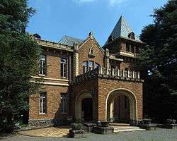 | 35°39′44″N 139°40′49″E / 35.66220492°N 139.68015108°E | |
| Former Residence of Prince Asaka 旧朝香宮邸 kyū-Asaka-no-miya tei | 1933-36 | Minato | Tokyo | designation comprises five components: main building, warehouse, garage, and front gate (1933), and tea house (1936); now the Tokyo Metropolitan Teien Art Museum | 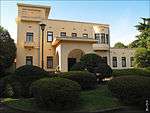 | 35°38′13″N 139°43′09″E / 35.63687095°N 139.71929551°E | |
| Former Tokyo Science Museum: main building 旧東京科学博物館本館 kyū-Tōkyō Kagaku Hakubutsukan honkan | 1931 | Taitō | Tokyo | part of the rebuilding after the Great Kantō earthquake; now the National Museum of Nature and Science | 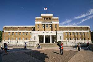 | 35°42′59″N 139°46′35″E / 35.71638985°N 139.77640333°E | |
| Former Tokyo Imperial Museum: main building 旧東京科学博物館本館 kyū-Tōkyō Teishitsu Hakubutsukan honkan | 1937 | Taitō | Tokyo | constructed after the Great Kantō earthquake at a cost of six million yen after the design by Watanabe Hitoshi; now the Tokyo National Museum[3] | 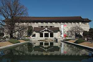 | 35°43′07″N 139°46′35″E / 35.71869186°N 139.77631825°E | |
| Former Baba Family Ushigome Residence 旧馬場家牛込邸 kyū-Baba-ke Ushigome tei | 1928 | Shinjuku | Tokyo | 35°41′56″N 139°44′19″E / 35.69882194°N 139.738515°E | |||
| National Museum of Western Art: main building 国立西洋美術館本館 Kokuritsu Seiyō Bijutsukan honkan | 1959 | Taitō | Tokyo | by Le Corbusier; component of the serial UNESCO World Heritage List inscription The Architectural Work of Le Corbusier: an Outstanding Contribution to the Modern Movement;[4] not a National Treasure | 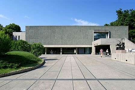 | 35°42′56″N 139°46′33″E / 35.71544228°N 139.77585345°E | |
| Mitsui main building 三井本館 Mitsui honkan | 1929 | Chūō | Tokyo | built to replace the 1889 headquarters, heavily damaged in the Great Kantō earthquake; now houses the Mitsui Memorial Museum[5][6] |  | 35°41′11″N 139°46′23″E / 35.68631455°N 139.77316571°E | |
| Jiyū Gakuen House of Tomorrow 自由学園明日館 Jiyū Gakuen myōnichikan | 1927 | Toshima | Tokyo | by Frank Lloyd Wright; formerly the Jiyu Gakuen Girls' School; designation comprises four components: central building (1921), east classroom building (1925), west classroom building (1922), and lecture hall (1927) | 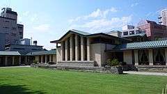 | 35°43′36″N 139°42′26″E / 35.72668075°N 139.70723087°E | |
| Kachidoki Bridge 勝鬨橋 Kachidoki bashi | 1940 | Chūō | Tokyo | movable bridge | 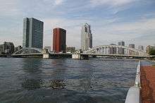 | 35°39′44″N 139°46′30″E / 35.66223483°N 139.77491824°E | |
| Kiyosu Bridge 勝鬨橋 Kiyosu bashi | 1928 | Chūō | Tokyo | suspension bridge reconstructed after the Great Kantō earthquake |  | 35°40′57″N 139°47′31″E / 35.68242422°N 139.79188212°E | |
| Waseda University Okuma Memorial Hall 早稲田大学大隈記念講堂 Waseda daigaku Ōkuma kinen kōdō | 1927 | Shinjuku | Tokyo | named after the founder, Ōkuma Shigenobu | 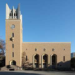 | 35°42′32″N 139°43′18″E / 35.70891402°N 139.72153606°E | |
| Sonkeikaku Bunko 尊経閣文庫 Sonkeikaku Bunko | 1928 | Meguro | Tokyo | designation comprises four components: library, archive, storage space, and gate |  | 35°39′46″N 139°40′46″E / 35.662884°N 139.679367°E | |
| Tsukiji Hongan-ji Main Hall 築地本願寺本堂 Tsukji Hongaji hondō | 1934 | Chūō | Tokyo | by Itō Chūta | 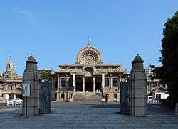 | 35°39′59″N 139°46′20″E / 35.66651194°N 139.77227194°E | |
| Meiji Life Insurance Mutual headquarters: main building 明治生命保険相互会社本社本館 Meiji seimei hokensō gogaisha honsha honkan | 1934 | Chiyoda | Tokyo | now the headquarters of Meiji Yasuda Life Insurance Company | 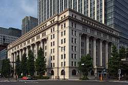 | 35°40′44″N 139°45′42″E / 35.67896494°N 139.76163183°E | |
| Takashimaya Tokyo store 明治生命保険相互会社本社本館 Takashimaya Tōkyō-ten | 1933 | Chūō | Tokyo | occupies an entire city block | 35°40′51″N 139°46′25″E / 35.68078333°N 139.7734784°E | ||
| Japan National Route 1 Hakone Yumoto road facilities 国道一号箱根湯本道路施設 Kokudō ichigō Hakone Yumoto dōro shisetsu | 1930-31 | Hakone | Kangawa | designation comprises three components: the Chitose Bridge (1930), Kanrei Dōmon tunnel (1931), and Asahi Bridge (1933) | 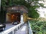 | 35°13′57″N 139°05′47″E / 35.23258224°N 139.09639263°E | |
| Former Sado Mining Sites 旧佐渡鉱山採鉱施設 kyū-Sado kōzan saikō shisetsu | 1937-1940 | Sado | Niigata | designation comprises eight components: great shaft tower (1940), associated chamber (1940), tunnels (1940), ore crushing facility (1937), conveyor belts (1938), machinery workshop (1940), and two Meiji-period bridges; The Sado complex of heritage mines, primarily gold mines have been submitted for inscription on the UNESCO World Heritage List[7] | 38°02′36″N 138°15′36″E / 38.04326374°N 138.25986432°E | ||
| Bandai Bridge 萬代橋 Bandai bashi | 1929 | Niigata | Niigata | 306.9 m long, 22 m wide | 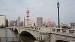 | 37°55′11″N 139°03′11″E / 37.9195999°N 139.05307286°E | |
| Shiraiwa Check Dam Facility 白岩堰堤砂防施設 Shiraiwa entei sabō shisetsu | 1939 | Toyama | Toyama | check dam to reduce erosion and flooding; designation comprises four components: main dam (1939), sub-dam (1919), boards (1939), and shoring works (1939) | 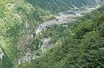 | 36°32′55″N 137°32′04″E / 36.54851948°N 137.53453884°E | |
| Fugan Canal Lock Facility (Nakajima Lock Gate) 富岩運河水閘施設 (中島閘門) Fugan unga suikō shisetsu (Nakajima kōmon) | 1934 | Toyama | Toyama | designation comprises five components: lock, spillway, Nakajima Bridge (two components), and control room | 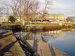 | 36°43′32″N 137°32′04″E / 36.72560707°N 137.53453884°E | |
| Katakurakan 片倉館 Katakurakan | 1928 | Suwa | Nagano | western-style spa complex; designation comprises three components: bath house, meeting hall, and connecting corridor | 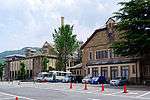 | 36°02′54″N 138°06′47″E / 36.04844246°N 138.11314514°E | |
| Atami Hyūga Family Villa Annex 旧日向家熱海別邸地下室 kyū-Hyūga-ke Atami bettei chikashitsu | 1936 | Atami | Shizuoka | by Bruno Taut | 35°06′12″N 139°04′54″E / 35.1033748°N 139.08161794°E | ||
| Aichi Prefectural Government Office 愛知県庁舎 Aichi-kenchōsha | 1938 | Nagoya | Aichi | 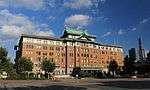 | 35°10′49″N 136°54′24″E / 35.18021426°N 136.90662217°E | ||
| Nagoya City Hall 名古屋市庁舎 Nagoya-shichōsha | 1933 | Nagoya | Aichi | 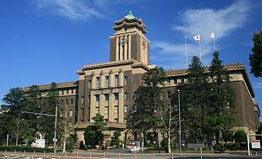 | 35°10′53″N 136°54′23″E / 35.18142779°N 136.90636042°E | ||
| Nagoya Higashiyama Botanical Garden greenhouse 名古屋市東山植物園温室前館 Nagoya-shi Higashiyama shokubutsuen | 1936 | Nagoya | Aichi | one of the first iron and glass buildings in the country |  | 35°09′15″N 136°58′56″E / 35.15430049°N 136.98216324°E | |
| Hinjitsukan 旧賓日館 kyū-Hinjitsukan | 1935 | Ise | Mie | guesthouse for visitors to Ise Jingu; designation comprises three components: main building (1887), storeroom (1887), and hall (1935) | 34°30′29″N 136°47′04″E / 34.50809734°N 136.78440859°E | ||
| Haiseiden 俳聖殿 Haiseiden | 1942 | Iga | Mie | by Itō Chūta for the 300th anniversary celebrations of Matsuo Bashō; in the grounds of Iga Ueno Castle | 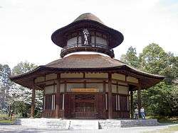 | 34°46′19″N 136°07′43″E / 34.77184023°N 136.1285581°E | |
| Suehiro Bridge 末広橋梁 Suehiro kyōryō | 1930 | Yokkaichi | Mie | bascule bridge; former Yokkaichi Port Station railway bridge | .JPG) | 34°57′16″N 136°38′00″E / 34.95458003°N 136.63327977°E | |
| Kamigamo Jinja 賀茂別雷神社 Kamigamo Jinja Kataoka hashi | 1926 | Kyoto | Kyoto | designation comprises thirty-four components, mainly dating to the early Edo period, also including the Kataoka Bridge (片岡橋) of 1926 | 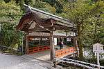 | 35°03′38″N 135°45′10″E / 35.06051834°N 135.75272852°E | |
| Nomura Hekiunsō 野村碧雲荘 Nomura Hekiunsō | 1928 | Kyoto | Kyoto | villa built for Tokushichi Nomura II in the grounds of Nanzen-ji; the gardens use water from Lake Biwa Canal; designation comprises seventeen components, including a Noh stage and chashitsu; six date from the Taishō era and the remainder from 1928 | 35°00′49″N 135°47′35″E / 35.01353526°N 135.79302579°E | ||
| Ōe Bridge and Yodoya Bridge 大江橋及び淀屋橋 Ōe bashi oyobi Yodoya bashi | 1935 | Osaka | Osaka | over the Kyū-Yodo River via Nakanoshima; Yodoya Bridge pictured | 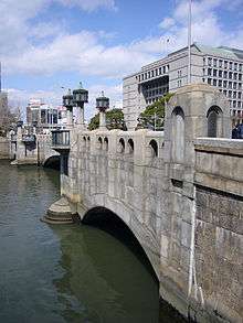 | 34°41′41″N 135°30′04″E / 34.69473248°N 135.50114385°E | |
| Mengyō Kaikan 綿業会館 Mengyō kaikan | 1931 | Osaka | Osaka | for leaders of the textile industry |  | 34°41′08″N 135°30′14″E / 34.68544593°N 135.50383668°E | |
| Kobe College 神戸女学院 Kōbe jo-gakuin | 1933 | Kobe | Hyōgo | designation comprises twelve components | 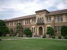 | 34°45′39″N 135°21′07″E / 34.760833°N 135.351833°E | |
| Anglican Church in Japan - Nara Episcopal Church 日本聖公会奈良基督教会 Nihon seikōkai Nara Kirisuto kyōkai | 1937 | Nara | Nara | designation comprises two components: the church (1930) and school building (192) | 34°40′58″N 135°49′46″E / 34.68275627°N 135.82946977°E | ||
| Former Kōya-guchi School Building 旧高野口尋常高等小学校校舎 kyū-Kōya-guchi jinjō kōtō shō gakkō kōsha kaikan | 1937 | Hashimoto | Wakayama | 34°18′14″N 135°33′11″E / 34.30383767°N 135.55299524°E | |||
| Mitani Waterworks Facility Site 旧美歎水源地水道施設 kyū-Mitani suigenchi suidō shisetsu | 1926-28 | Tottori | Tottori | designation comprises ten components, eight dating to the Taishō period, the fifth filtration pond to 1928 and the meter room to 1926-8 | 35°29′11″N 134°17′15″E / 35.48635487°N 134.28757652°E | ||
| Ishitani Family Residence 石谷家住宅 Ishitani-ke jūtaku | 1926-28 | Chizu | Tottori | designation with eight components, two dating to the Meiji period, three to the Taishō period, the main building to 1928, parlour to 1926-8, and family room to 1928 | 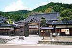 | 35°16′12″N 134°13′49″E / 35.27013223°N 134.23033923°E | |
| Hiroshima Peace Memorial Museum 広島平和記念資料館 Hiroshima heiwa kinen shiryōkan | 1955 | Hiroshima | Hiroshima | by Kenzo Tange; in Hiroshima Peace Memorial Park | 34°23′31″N 132°27′08″E / 34.39181677°N 132.45210905°E | ||
| Hiroshima World Peace Memorial Cathedral 世界平和記念聖堂 Sekai heiwa kinen seidō | 1954 | Hiroshima | Hiroshima | by Tōgo Murano | 34°23′44″N 132°28′04″E / 34.39562422°N 132.46778135°E | ||
| Watanabe Memorial Hall 渡辺翁記念会館 Sekai heiwa kinen seidō | 1937 | Ube | Yamaguchi | by Tōgo Murano; for industrialist Watanabe Sukesaku (渡辺祐策) | .jpg) | 33°57′29″N 131°14′41″E / 33.95812613°N 131.24463502°E | |
| Arichi Family Residence 有近家住宅 Arichi-ke jūtaku | 1926-45 | Yamaguchi | Yamaguchi | designation comprises seven components, one dating to the Meiji period, three to the Taishō period, and a Nagaya (1929), pickles hut (1926–45), and bottle washery (1936) | 34°13′53″N 131°39′48″E / 34.23147117°N 131.66324044°E | ||
| Mikawa Family Residence 三河家住宅 Mikawa-ke jūtaku | 1928 | Tokushima | Tokushima | illustrates the proliferation of modern materials and styles | 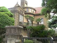 | 34°03′59″N 134°33′22″E / 34.06643276°N 134.55620371°E | |
| Hōnen'ike Dam 豊稔池堰堤 Hōnen-ike entei | 1929 | Kan'onji | Kagawa | 145.5 m wide, 30.4 m high | 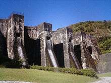 | 34°02′30″N 133°41′05″E / 34.04177038°N 133.68460847°E | |
| Nagahama Ōhashi Bridge 長浜大橋 Nagahama-ōhashi | 1935 | Ōzu | Ehime | 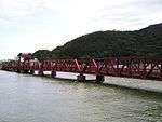 | 33°36′36″N 132°28′47″E / 33.61004579°N 132.47968715°E | ||
| Hizuchi Primary School 日土小学校 Hizuchi shōgakkō | 1956-58 | Yawatahama | Ehime | designation comprises two components, central block (1956) and east wing (1958) | 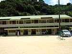 | 33°30′02″N 132°25′40″E / 33.50057015°N 132.4277976°E | |
| Yanase Forest Railway Facilities 旧魚梁瀬森林鉄道施設 kyū-Yanase shinrin tetsudō shisetsu | to 1941 | Kōchi | designation includes fourteen component tunnels and bridges, four from the Meiji period, five from the Taishō period and five from the Shōwa period | 33°29′15″N 134°00′09″E / 33.4874299°N 134.00262903°E | |||
| Shime Shaft Mine Intake 旧志免鉱業所竪坑櫓 kyū-Shime kōgyōsho tatekō yagura | 1943 | Shime | Fukuoka | for shaft mining in the Kasuya coal fields (糟屋炭田); 47.6 m | 33°35′26″N 130°29′09″E / 33.59047855°N 130.48573397°E | ||
| Chikugo River Lift Bridge 旧筑後川橋梁 (筑後川昇開橋) kyū-Chikugogawa kyōryō (Chikugogawa shōkaikyō) | 1935 | Ōkawa | Fukuoka | Vertical-lift bridge; 507.2 m | 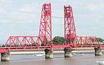 | 33°12′54″N 130°21′42″E / 33.21505534°N 130.36169856°E | |
| Nabeshima Family Residence 旧鍋島家住宅 kyū-Nabeshima-ke jūtaku | 1930 | Unzen | Nagasaki | designation comprises five components, dating from the Edo, Meiji and Shōwa periods (the main building) | 32°52′12″N 130°16′04″E / 32.87009579°N 130.2676469°E | ||
| Hakusui Dam Facilities 白水溜池堰堤水利施設 Hakusui tame-ike entei suiri shisetsu | 1938 | Taketa | Ōita | designation comprises two components, the main dam and sub-dam | 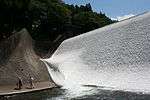 | 32°54′19″N 131°19′38″E / 32.90515518°N 131.32715962°E | |
| Tsukayama Awamori Production Facilities 津嘉山酒造所施設 Tsukayama shuzōsho shisetsu | 1935 | Nago | Okinawa | designation comprises two components: main building, which includes residential quarters; and the koji house | 26°35′29″N 127°59′00″E / 26.59149628°N 127.98321166°E | ||
| National Treasures | 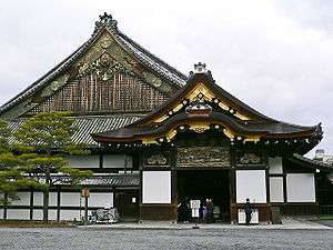  | |
|---|---|---|
| Important Cultural Properties |
| |
| Hokkaidō | ||
| Tōhoku |
| |
| Kantō |
| |
| Chūbu |
| |
| Kansai |
| |
| Chūgoku |
| |
| Shikoku | ||
| Kyūshū |
| |
| Okinawa | ||
1 | ||
See also
References
- ↑ "Cultural Properties for Future Generations". Agency for Cultural Affairs. Retrieved 8 October 2016.
- ↑ "Database of National Cultural Properties: 国宝・重要文化財 (建造物): 昭和" (in Japanese). Agency for Cultural Affairs. Retrieved 8 October 2016.
- ↑ "Construction of the new Honkan: The Museum during World War II". Tokyo National Museum. Retrieved 27 August 2013.
- ↑ "The Architectural Work of Le Corbusier, an Outstanding Contribution to the Modern Movement". UNESCO. Retrieved 8 October 2016.
- ↑ Watanabe Hiroshi (2001). The Architecture of Tōkyō. Edition Axel Menges. p. 99. ISBN 3-930698-93-5.
- ↑ "Mitsui Honkan (architectural drawings)" (PDF). Architectural Institute of Japan. Retrieved 20 February 2012.
- ↑ "The Sado complex of heritage mines, primarily gold mines". UNESCO. Retrieved 8 October 2016.
This article is issued from
Wikipedia.
The text is licensed under Creative Commons - Attribution - Sharealike.
Additional terms may apply for the media files.