Lincoln County, Maine
| Lincoln County, Maine | ||
|---|---|---|
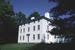 Pownalborough Courthouse in Dresden. | ||
| ||
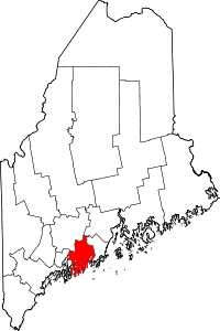 Location in the U.S. state of Maine | ||
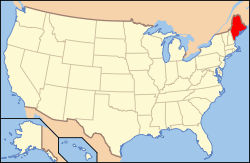 Maine's location in the U.S. | ||
| Founded | 1760 | |
| Named for | Lincoln, England | |
| Seat | Wiscasset | |
| Largest town | Waldoboro | |
| Area | ||
| • Total | 700 sq mi (1,813 km2) | |
| • Land | 456 sq mi (1,181 km2) | |
| • Water | 244 sq mi (632 km2), 35% | |
| Population (est.) | ||
| • (2010) | 34,216 | |
| • Density | 76/sq mi (29/km2) | |
| Congressional district | 1st | |
| Time zone | Eastern: UTC−5/−4 | |
| Website |
www | |

Lincoln County is a county located in the U.S. state of Maine. As of the 2010 census, the population was 34,457.[1] Its seat is Wiscasset.[2] The county was founded in 1760 from a portion of York County, Massachusetts and named after the English city Lincoln,[3] the birthplace of Massachusetts Bay Provincial Governor Thomas Pownall.[4]
At its founding, Lincoln County accounted for three-fifths of the state's land, and stretched east to Nova Scotia. Thirteen counties were cut out of this land including Sagadahoc County to the west.[5] The county flag is a traditional New England flag, adopted in 1977.[6]
Geography
According to the U.S. Census Bureau, the county has a total area of 700 square miles (1,800 km2), of which 456 square miles (1,180 km2) is land and 244 square miles (630 km2) (35%) is water.[7] It is the third-smallest county in Maine by area.
Adjacent counties
- Kennebec County, Maine — north
- Waldo County, Maine — northeast
- Knox County, Maine — east
- Sagadahoc County, Maine — west
Demographics
| Historical population | |||
|---|---|---|---|
| Census | Pop. | %± | |
| 1790 | 29,733 | — | |
| 1800 | 30,225 | 1.7% | |
| 1810 | 42,992 | 42.2% | |
| 1820 | 53,189 | 23.7% | |
| 1830 | 57,192 | 7.5% | |
| 1840 | 63,517 | 11.1% | |
| 1850 | 74,875 | 17.9% | |
| 1860 | 27,860 | −62.8% | |
| 1870 | 25,597 | −8.1% | |
| 1880 | 24,821 | −3.0% | |
| 1890 | 21,996 | −11.4% | |
| 1900 | 19,669 | −10.6% | |
| 1910 | 18,216 | −7.4% | |
| 1920 | 15,976 | −12.3% | |
| 1930 | 15,498 | −3.0% | |
| 1940 | 16,294 | 5.1% | |
| 1950 | 18,004 | 10.5% | |
| 1960 | 18,497 | 2.7% | |
| 1970 | 20,537 | 11.0% | |
| 1980 | 25,691 | 25.1% | |
| 1990 | 30,357 | 18.2% | |
| 2000 | 33,616 | 10.7% | |
| 2010 | 34,457 | 2.5% | |
| Est. 2016 | 34,216 | [8] | −0.7% |
| U.S. Decennial Census[9] 1790–1960[10] 1900–1990[11] 1990–2000[12] 2010–2016[1] | |||
2000 census
As of the 2000 census, there were 14,158 households, and 9,542 families residing in the county. The population density was 74 people per square mile (28/km²). There were 20,849 housing units at an average density of 46 per square mile (18/km²). The racial makeup of the county was 98.46% White, 0.17% Black or African American, 0.26% Native American, 0.37% Asian, 0.02% Pacific Islander, 0.10% from other races, and 0.61% from two or more races. 0.46% of the population were Hispanic or Latino of any race. 25.3% were of English, 15.4% United States or American, 11.2% Irish, 9.0% German and 7.3% French ancestry. Most of those claiming to be of "American" ancestry are actually of English descent, but have family that has been in the country for so long, in many cases since the early seventeenth century that they choose to identify simply as "American".[13][14][15][16][17] 97.7% spoke English and 1.0% French as their first language.
There were 14,158 households out of which 28.20% had children under the age of 18 living with them, 56.10% were married couples living together, 7.70% had a female householder with no husband present, and 32.60% were non-families. 26.70% of all households were made up of individuals and 12.10% had someone living alone who was 65 years of age or older. The average household size was 2.35 and the average family size was 2.82.
In the county, the population was spread out with 22.70% under the age of 18, 5.50% from 18 to 24, 25.60% from 25 to 44, 28.10% from 45 to 64, and 18.20% who were 65 years of age or older. The median age was 43 years. For every 100 females there were 95.10 males. For every 100 females age 18 and over, there were 92.00 males.
The median income for a household in the county was $38,686, and the median income for a family was $45,427. Males had a median income of $31,209 versus $23,161 for females. The per capita income for the county was $20,760. About 6.60% of families and 10.10% of the population were below the poverty line, including 12.80% of those under age 18 and 9.50% of those age 65 or over.
2010 census
As of the 2010 United States Census, there were 34,457 people, 15,149 households, and 9,749 families residing in the county.[18] The population density was 75.6 inhabitants per square mile (29.2/km2). There were 23,493 housing units at an average density of 51.5 per square mile (19.9/km2).[19] The racial makeup of the county was 97.6% white, 0.5% Asian, 0.3% American Indian, 0.3% black or African American, 0.1% from other races, and 1.1% from two or more races. Those of Hispanic or Latino origin made up 0.8% of the population.[18] In terms of ancestry, 30.4% were English, 17.7% were Irish, 13.4% were German, 8.6% were Scottish, and 8.5% were American.[20]
Of the 15,149 households, 24.7% had children under the age of 18 living with them, 51.6% were married couples living together, 8.8% had a female householder with no husband present, 35.6% were non-families, and 28.9% of all households were made up of individuals. The average household size was 2.24 and the average family size was 2.72. The median age was 48.1 years.[18]
The median income for a household in the county was $47,678 and the median income for a family was $58,028. Males had a median income of $40,816 versus $31,473 for females. The per capita income for the county was $28,003. About 7.7% of families and 10.8% of the population were below the poverty line, including 16.2% of those under age 18 and 9.9% of those age 65 or over.[21]
Politics
Voter registration
| Voter registration and party enrollment as of June 2014[22] | |||||
|---|---|---|---|---|---|
| Unenrolled | 9,345 | 35.44% | |||
| Republican | 8,636 | 32.75% | |||
| Democratic | 7,328 | 27.79% | |||
| Green Independent | 1,055 | 4.00% | |||
| Total | 26,364 | 100% | |||
| Year | Republican | Democratic | Third parties |
|---|---|---|---|
| 2016 | 45.2% 9,727 | 47.6% 10,241 | 7.1% 1,535 |
| 2012 | 42.9% 8,899 | 54.5% 11,315 | 2.6% 543 |
| 2008 | 43.0% 9,287 | 55.1% 11,886 | 1.9% 411 |
| 2004 | 46.8% 10,370 | 51.3% 11,351 | 1.9% 421 |
| 2000 | 48.1% 9,457 | 43.9% 8,634 | 8.0% 1,580 |
| 1996 | 35.1% 6,372 | 44.7% 8,130 | 20.2% 3,671 |
| 1992 | 33.7% 6,405 | 35.3% 6,714 | 31.1% 5,917 |
| 1988 | 61.8% 9,837 | 37.3% 5,939 | 0.9% 144 |
| 1984 | 67.7% 10,312 | 32.0% 4,869 | 0.4% 55 |
| 1980 | 52.1% 7,434 | 33.5% 4,776 | 14.4% 2,049 |
| 1976 | 59.0% 7,554 | 37.7% 4,818 | 3.3% 425 |
| 1972 | 72.3% 7,580 | 27.7% 2,903 | 0.0% 4 |
| 1968 | 61.1% 5,659 | 36.5% 3,380 | 2.4% 222 |
| 1964 | 43.8% 3,984 | 56.1% 5,099 | 0.1% 11 |
| 1960 | 76.4% 7,562 | 23.6% 2,337 | 0.0% 0 |
| 1956 | 86.1% 7,191 | 13.9% 1,164 | 0.0% 0 |
| 1952 | 83.8% 6,766 | 16.1% 1,299 | 0.1% 9 |
| 1948 | 80.5% 4,743 | 18.6% 1,095 | 1.0% 56 |
| 1944 | 70.0% 4,919 | 29.9% 2,102 | 0.1% 9 |
| 1940 | 68.4% 5,244 | 31.5% 2,415 | 0.1% 5 |
| 1936 | 72.6% 5,252 | 25.6% 1,850 | 1.8% 130 |
| 1932 | 63.8% 4,666 | 35.6% 2,602 | 0.6% 41 |
| 1928 | 78.9% 4,470 | 20.8% 1,181 | 0.3% 18 |
| 1924 | 77.4% 3,311 | 20.5% 878 | 2.1% 91 |
| 1920 | 73.6% 3,668 | 25.2% 1,256 | 1.2% 59 |
| 1916 | 50.0% 1,781 | 48.2% 1,718 | 1.8% 65 |
| 1912 | 12.3% 457 | 43.9% 1,633 | 43.8% 1,631 |
| 1908 | 56.4% 1,693 | 39.9% 1,196 | 3.7% 111 |
Communities
Towns
Census-designated places
Other unincorporated villages
See also
References
- 1 2 "State & County QuickFacts". United States Census Bureau. Archived from the original on July 13, 2011. Retrieved August 19, 2013.
- ↑ "Find a County". National Association of Counties. Retrieved 2011-06-07.
- ↑ "north by east". Down East: The Magazine of Maine: 19. June 2008.
- ↑ "Lincoln County Maine". lincolncountymaine. Retrieved 2018-08-25.
- ↑ "Archived copy". Archived from the original on 2009-09-26. Retrieved 2010-02-11.
- ↑ The Flag of New England Page Archived 2007-04-01 at the Wayback Machine.
- ↑ "2010 Census Gazetteer Files". United States Census Bureau. August 22, 2012. Archived from the original on September 9, 2014. Retrieved September 7, 2014.
- ↑ "Population and Housing Unit Estimates". Retrieved June 9, 2017.
- ↑ "U.S. Decennial Census". United States Census Bureau. Retrieved September 7, 2014.
- ↑ "Historical Census Browser". University of Virginia Library. Retrieved September 7, 2014.
- ↑ "Population of Counties by Decennial Census: 1900 to 1990". United States Census Bureau. Retrieved September 7, 2014.
- ↑ "Census 2000 PHC-T-4. Ranking Tables for Counties: 1990 and 2000" (PDF). United States Census Bureau. Retrieved September 7, 2014.
- ↑ Sharing the Dream: White Males in a Multicultural America By Dominic J. Pulera.
- ↑ Reynolds Farley, 'The New Census Question about Ancestry: What Did It Tell Us?', Demography, Vol. 28, No. 3 (August 1991), pp. 414, 421.
- ↑ Stanley Lieberson and Lawrence Santi, 'The Use of Nativity Data to Estimate Ethnic Characteristics and Patterns', Social Science Research, Vol. 14, No. 1 (1985), pp. 44–6.
- ↑ Stanley Lieberson and Mary C. Waters, 'Ethnic Groups in Flux: The Changing Ethnic Responses of American Whites', Annals of the American Academy of Political and Social Science, Vol. 487, No. 79 (September 1986), pp. 82–86.
- ↑ Mary C. Waters, Ethnic Options: Choosing Identities in America (Berkeley: University of California Press, 1990), p. 36.
- 1 2 3 "DP-1 Profile of General Population and Housing Characteristics: 2010 Demographic Profile Data". United States Census Bureau. Retrieved 2016-01-21.
- ↑ "Population, Housing Units, Area, and Density: 2010 - County". United States Census Bureau. Retrieved 2016-01-21.
- ↑ "DP02 SELECTED SOCIAL CHARACTERISTICS IN THE UNITED STATES – 2006-2010 American Community Survey 5-Year Estimates". United States Census Bureau. Retrieved 2016-01-21.
- ↑ "DP03 SELECTED ECONOMIC CHARACTERISTICS – 2006-2010 American Community Survey 5-Year Estimates". United States Census Bureau. Retrieved 2016-01-21.
- ↑ "Registration and Party Enrollment Statistics as of June 10, 2014" (PDF). Maine Bureau of Corporations. Archived from the original (PDF) on October 30, 2014.
- ↑ Leip, David. "Dave Leip's Atlas of U.S. Presidential Elections". uselectionatlas.org. Retrieved 2018-08-25.
External links
| Wikimedia Commons has media related to Lincoln County, Maine. |
- Official Website of Lincoln County
- Maine Genealogy: Lincoln County, Maine
- Lincoln County Television, a Public, Educational and Government access television station serving 10 towns in Lincoln County
- Wiscasset Newspaper, serving the Lincoln County Seat and its Route 1 neighbors since 1970
- Boothbay Register, serving Boothbay, Boothbay Harbor, Edgecomb and Southport since 1876
Places adjacent to Lincoln County, Maine | ||||||||||
|---|---|---|---|---|---|---|---|---|---|---|
| ||||||||||
Municipalities and communities of Lincoln County, Maine, United States | ||
|---|---|---|
| Towns | | |
| Plantation | ||
| Gore | ||
| CDPs | ||
| Other villages | ||
Augusta (capital) | |
| Topics |
|
| Society |
|
| Regions | |
| Counties | |
| Cities | |
| Largest towns | |