Waterville, Maine
| Waterville, Maine | ||
|---|---|---|
| City | ||
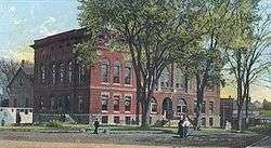 City Hall and Opera House in 1905 | ||
| ||
| Nickname(s): Elm City | ||
 Location in Kennebec County and the state of Maine. | ||
 Waterville, Maine Location in the United States | ||
| Coordinates: 44°33′7″N 69°38′45″W / 44.55194°N 69.64583°WCoordinates: 44°33′7″N 69°38′45″W / 44.55194°N 69.64583°W | ||
| Country | United States | |
| State | Maine | |
| County | Kennebec | |
| Incorporated (town) | June 23, 1802 | |
| Incorporated | January 12, 1888 | |
| Government | ||
| • Type | Mayor and council-manager | |
| • Body | Waterville City Council | |
| • Mayor | Nick Isgro | |
| • City Manager | Mike Roy | |
| Area[1] | ||
| • Total | 14.05 sq mi (36.39 km2) | |
| • Land | 13.58 sq mi (35.17 km2) | |
| • Water | 0.47 sq mi (1.22 km2) | |
| Elevation | 108 ft (33 m) | |
| Population [2] | ||
| • Total | 16,406 | |
| • Density | 1,200/sq mi (450/km2) | |
| Time zone | UTC−5 (Eastern (EST)) | |
| • Summer (DST) | UTC−4 (EDT) | |
| ZIP codes | 04901 | |
| Area code(s) | 207 | |
| FIPS code | 23-80740 | |
| GNIS feature ID | 0577893 | |
| Website | www.waterville-me.gov | |
Waterville is a city in Kennebec County of the U.S. state of Maine, United States, on the west bank of the Kennebec River. Home to Colby College and Thomas College, the population was 16,406 at the 2016 census.[3] Waterville is also the latter of the cities which make up the Augusta-Waterville, ME Micropolitan Statistical Area.
Waterville has a Mayor and council-manager form of government, led by a mayor and a seven-member city council. The city council is the governing board, and the city manager is the chief administrative officer of the City, responsible for the management of all City affairs. The city is also home to Fox affiliate WPFO and Daystar rebroadcaster WFYW-LP both serving the Portland market and to several radio stations including Colby's WMHB, country WEBB, adult standards WTVL and MPBN on 91.3 FM. The film Wet Hot American Summer is set in Waterville.
History
The area now known as Waterville was once inhabited by the Canibas tribe of Abenaki (Indigenous People). Called Taconnet after Chief Taconnet, the main village was located on the east bank of the Kennebec River at its confluence with the Sebasticook River at what is now Winslow. Known as Ticonic by English settlers, it was burned in 1692 during King William's War, after which the Canibas tribe abandoned the area. Fort Halifax was built by General John Winslow in 1754, and the last skirmish with Indigenous peoples occurred on May 18, 1757.[4]
The township would be organized as Kingfield Plantation, then incorporated as Winslow in 1771. When residents on the west side of the Kennebec found themselves unable to cross the river to attend town meetings, Waterville was founded from the western parts of Winslow and incorporated on June 23, 1802. In 1824 a bridge was built joining the communities. Early industries included fishing, lumbering, agriculture and ship building, with larger boats launched in spring during freshets. By the early 1900s, there were five shipyards in the community.[5]
Ticonic Falls blocked navigation farther upriver, so Waterville developed as the terminus for trade and shipping. The Kennebec River and Messalonskee Stream provided water power for mills, including several sawmills, a gristmill, a sash and blind factory, a furniture factory and a shovel handle factory. There was also a carriage and sleigh factory, boot shop, brickyard and tannery. On September 27, 1849, the Androscoggin and Kennebec Railroad opened to Waterville. It would become part of the Maine Central Railroad, which in 1870 established locomotive and car repair shops in the thriving mill town. West Waterville (renamed Oakland) was set off as a town in 1873. Waterville was incorporated as a city on January 12, 1888.[6]
The Ticonic Water Power & Manufacturing Company was formed in 1866 and soon built a dam across the Kennebec. After a change of ownership in 1873, the company began construction on what would become the Lockwood Manufacturing Company, a cotton textile plant. A second mill was added, and by 1900 the firm dominated the riverfront and employed 1,300 workers. Lockwood Mills survived until the mid-1950s. The iron Waterville-Winslow Footbridge opened in 1901, as a means for Waterville residents to commute to Winslow for work in the Hollingsworth & Whitney Co. and Wyandotte Worsted Co. mills, but in less than a year was carried away by the highest river level since 1832. Rebuilt in 1903, it would be called the Two Cent Bridge because of its toll.[7] In 1902, the Beaux-Arts style City Hall and Opera House designed by George Gilman Adams was dedicated. In 2002, the C. F. Hathaway Company, one of the last remaining factories in the United States producing high-end dress shirts, was purchased by Warren Buffett's Berkshire Hathaway company and was closed after over 160 years of operation in the city.[7]
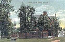
Waterville also developed as an educational center. In 1813, The Maine Literary and Theological Institution was established. It would be renamed Waterville College in 1821, then Colby College in 1867. Thomas College was established in 1894. The Latin School was founded in 1820 to prepare students to attend Colby and other colleges, and was subsequently named Waterville Academy, Waterville Classical Institute, and Coburn Classical Institute; the Institute merged with the Oak Grove School in Vassalboro in 1970, and remained open until the 1980s. The first public high school was built in 1877, while the current Waterville Senior High School was built in 1961.[4]
| Wikimedia Commons has media related to Postcards of Waterville, Maine. |
Geography
Waterville is located at 44°33′07″N 69°38′45″W / 44.552051°N 69.645839°W.[8]
According to the United States Census Bureau, the city has a total area of 14.05 square miles (36.39 km2), of which 13.58 square miles (35.17 km2) is land and 0.47 square miles (1.22 km2) is water.[1] Situated beside the Kennebec River, Waterville is drained by the Messalonskee Stream.
Waterville is served by Interstate 95 (Maine), Maine State Routes 137, 104 and U.S. Route 201. It is bordered by Fairfield on the north, Winslow on the east, Sidney on the south and Oakland on the west.
Climate
This climatic region is typified by large seasonal temperature differences, with warm to hot (and often humid) summers and cold (sometimes severely cold) winters. According to the Köppen Climate Classification system, Waterville has a humid continental climate, abbreviated "Dfb" on climate maps.[9]
| Climate data for Waterville, Maine | |||||||||||||
|---|---|---|---|---|---|---|---|---|---|---|---|---|---|
| Month | Jan | Feb | Mar | Apr | May | Jun | Jul | Aug | Sep | Oct | Nov | Dec | Year |
| Record high °F (°C) | 61.0 (16.1) |
60.1 (15.6) |
84.9 (29.4) |
90.0 (32.2) |
98.1 (36.7) |
98.1 (36.7) |
100.9 (38.3) |
98.1 (36.7) |
96.1 (35.6) |
90.0 (32.2) |
73.9 (23.3) |
66.9 (19.4) |
100.94 (38.3) |
| Average high °F (°C) | 27.6 (−2.4) |
31.8 (−0.1) |
40.4 (4.7) |
53.1 (11.7) |
65.2 (18.4) |
73.8 (23.2) |
79.2 (26.2) |
78 (26) |
69.6 (20.9) |
57.2 (14) |
45.2 (7.3) |
33.5 (0.8) |
54.6 (12.6) |
| Average low °F (°C) | 11 (−12) |
14.5 (−9.7) |
31.9 (−0.1) |
34.6 (1.4) |
44.6 (7) |
54.2 (12.3) |
59.9 (15.5) |
58.5 (14.7) |
50.5 (10.3) |
39.6 (4.2) |
30.6 (−0.8) |
18.6 (−7.4) |
37.4 (3) |
| Record low °F (°C) | −36 (−38) |
−35 (−37) |
−20 (−29) |
−0.9 (−18.3) |
21.9 (−5.6) |
26.1 (−3.3) |
37.0 (2.8) |
30.9 (−0.6) |
19.9 (−6.7) |
14.0 (−10) |
−6 (−21) |
−38.9 (−39.4) |
−38.92 (−39.4) |
| Average precipitation inches (mm) | 2.61 (66.3) |
2.43 (61.7) |
3.37 (85.6) |
3.79 (96.3) |
3.69 (93.7) |
3.56 (90.4) |
3.42 (86.9) |
3.31 (84.1) |
3.74 (95) |
4.36 (110.7) |
4.36 (110.7) |
3.24 (82.3) |
41.88 (1,063.8) |
| Source: [10][11] | |||||||||||||
Redevelopment
Like many other towns in Maine and in the United States, Waterville has seen development in the suburbs and the decline of the downtown area.[12] There have been new businesses and new facilities built by Inland Hospital on Kennedy Memorial Drive. WalMart, Home Depot, and a small strip mall of other stores have been built in the northern part of the city as part of an open-air shopping center. Because of this growth, the existing and now-neighboring Elm Plaza shopping center has recently had its exterior renovated and filled most or all of its previous vacancies.
In contrast, the downtown area has had its share of hardships due to chain store growth in the city. Stores that had a long history in the downtown area have closed in recent decades, including Levine's, Butlers, Sterns, Dunhams, Alvina and Delias, and LaVerdieres. The large vacancy in The Concourse shopping center that once housed the Ames, Zayre department store, as well as Brooks Pharmacy is struggling to find tenants; as is the now vacant Main Street location of a CVS pharmacy (it moved to a brand new building on Kennedy Memorial Drive).[13] Organizations like Waterville Main St continue their efforts to revitalize downtown.
Developer Paul Boghossian has converted the old Hathaway Mill to retail, office, and residential use.[14] MaineGeneral Health agreed at the end of June 2007 to become the first tenant.[15]
Demographics
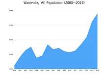
| Historical population | |||
|---|---|---|---|
| Census | Pop. | %± | |
| 1810 | 1,314 | — | |
| 1820 | 1,719 | 30.8% | |
| 1830 | 2,216 | 28.9% | |
| 1840 | 2,971 | 34.1% | |
| 1850 | 3,964 | 33.4% | |
| 1860 | 4,390 | 10.7% | |
| 1870 | 4,852 | 10.5% | |
| 1880 | 4,672 | −3.7% | |
| 1890 | 7,107 | 52.1% | |
| 1900 | 9,477 | 33.3% | |
| 1910 | 11,458 | 20.9% | |
| 1920 | 13,351 | 16.5% | |
| 1930 | 15,454 | 15.8% | |
| 1940 | 16,688 | 8.0% | |
| 1950 | 18,287 | 9.6% | |
| 1960 | 18,695 | 2.2% | |
| 1970 | 18,192 | −2.7% | |
| 1980 | 17,779 | −2.3% | |
| 1990 | 17,173 | −3.4% | |
| 2000 | 15,605 | −9.1% | |
| 2010 | 15,722 | 0.7% | |
| Est. 2016 | 16,406 | [16] | 4.4% |
| U.S. Decennial Census[17] | |||
2010 census
As of the census[2] of 2010, there were 15,722 people, 6,370 households, and 3,274 families residing in the city. The population density was 1,157.7 inhabitants per square mile (447.0/km2). There were 7,065 housing units at an average density of 520.3 per square mile (200.9/km2). The racial makeup of the city was 93.9% White, 1.1% African American, 0.6% Native American, 1.2% Asian, 0.1% Pacific Islander, 0.8% from other races, and 2.4% from two or more races. Hispanic or Latino of any race were 2.4% of the population.
There were 6,370 households of which 24.8% had children under the age of 18 living with them, 32.9% were married couples living together, 13.7% had a female householder with no husband present, 4.8% had a male householder with no wife present, and 48.6% were non-families. 38.9% of all households were made up of individuals and 15.5% had someone living alone who was 65 years of age or older. The average household size was 2.13 and the average family size was 2.80.
The median age in the city was 36.8 years. 17.9% of residents were under the age of 18; 18.9% were between the ages of 18 and 24; 21.7% were from 25 to 44; 24.7% were from 45 to 64; and 16.7% were 65 years of age or older. The gender makeup of the city was 46.8% male and 53.2% female.
2000 census
As of the census[18] of 2000, there were 15,605 people, 6,218 households, and 3,370 families residing in the city. The population density was 1,148.7 people per square mile (443.3/km²). There were 6,819 housing units at an average density of 501.9 per square mile (193.7/km²). The racial makeup of the city was 95.81% White, 0.78% African American, 0.56% Native American, 1.03% Asian, 0.03% Pacific Islander, 0.42% from other races, and 1.36% from two or more races. Hispanic or Latino of any race were 1.10% of the population. 32% reported French and French Canadian ancestry, 18% English, 11% Irish, and 6% German.
There are 6,218 households out of which 26.3% have children under the age of 18 living with them, 38.2% were married couples living together, 12.1% had a female householder with no husband present, and 45.8% were non-families. 38.6% of all households were made up of individuals and 16.2% had someone living alone who was 65 years of age or older. The average household size was 2.13 and the average family size was 2.84.
In the city, the population was spread out with 19.7% under the age of 18, 18.5% from 18 to 24, 24.1% from 25 to 44, 19.5% from 45 to 64, and 18.1% who were 65 years of age or older. The median age was 36 years. For every 100 females, there were 85.0 males. For every 100 females age 18 and over, there were 81.7 males.
The median income for a household in the city was $26,816, and the median income for a family was $38,052. Males had a median income of $30,086 versus $22,037 for females. The per capita income for the city was $16,430. 19.2% of the population and 15.1% of families were below the federal poverty level. Statewide, 10.9% of the population was below the poverty level.[19] In Kennebec County, 11.1% of the population was below the federal poverty level. Thus, although the county poverty rate is close to the state poverty rate, the poverty rate for Waterville is higher—typical for a regional center whose suburbs have grown in population.
Out of the total population, 29.7% of those under the age of 18 and 14.7% of those 65 and older were living below the poverty line.
Government
Local government
_IMG_2652.JPG)
Waterville has a Mayor and council-manager form of government, led by a mayor and a seven-member city council. The city council is the governing board, and the city manager is the chief administrative officer of the City, responsible for the management of all City affairs. For 117 years, the Mayor served as the chief executive officer of the City. In 2005 voters approved a new charter, which changed Waterville's government from a strong Mayor–council government to the Council-Manager format.
In May, 2018, the AP reported that Republican Mayor Nick Isgro (reelected in November, 2016) was to face a recall vote later in the year. The recall election was a result of Mr Isgro's since-deleted tweet in support of Fox News' news commentator Laura Ingraham in her Twitter conflict with Parkland, Fla., shooting survivior David Hogg. Isgro lambasted the recall effort as the work of "outside, well-funded forces" who were attempting to take control of "Our City," discounting the importance of the three-word tweet.[20][21]
Political makeup
Waterville is considered a Democratic stronghold in Maine's 1st congressional district.[22][23] Barack Obama received 70% of Waterville's votes in the 2008 presidential election.[24]
Voter registration
| Voter Registration and Party Enrollment as of June 2014[25] | |||||
|---|---|---|---|---|---|
| Party | Total Voters | Percentage | |||
| Democratic | 4,562 | 41.25% | |||
| Unenrolled | 4,200 | 37.98% | |||
| Republican | 1,940 | 17.54% | |||
| Green Independent | 356 | 3.21% | |||
| Total | 11,058 | 100% | |||
Transportation
- Robert LaFleur Airport
- Interstate 95
- US Route 201
- State Route 100A
- State Route 137
- State Route 32
- State Route 137 Business
- State Route 11
- State Route 104
- Pan Am Railways: Waterville Intermodal Facility[26][27]
Education
Waterville Public Schools serves the city.
It was a part of Kennebec Valley Consolidated Schools (AOS92) until July 1, 2018.[28]
In popular culture
Waterville is the set location of Camp Firewood in the Netflix show Wet Hot American Summer: First Day of Camp.
Media
Waterville is home to one daily newspaper, the Morning Sentinel and a weekly, The Colby Echo. The city is also home to Fox affiliate WPFO and Daystar rebroadcaster WFYW-LP both serving the Portland market and to several radio stations including Colby's WMHB, country WEBB, adult standards WTVL and MPBN on 91.3 FM.
Sister cities

Sites of interest


- Colby College
- Colby College Museum of Art
- Thomas College
- Atlantic Music Festival
- Maine International Film Festival
- Perkins Arboretum
- Waterville Historical Society - Redington Museum
- Waterville Public Library
- Waterville Opera House
- Waterville Main Street
- Waterville - Winslow Footbridge (Two Cent Bridge)
Notable people
See also
References
- 1 2 "US Gazetteer files 2010". United States Census Bureau. Archived from the original on 2012-01-24. Retrieved 2012-11-23.
- 1 2 "American FactFinder". United States Census Bureau. Retrieved 2012-11-23.
- ↑ "U.S. Census Bureau QuickFacts: Waterville city, Maine". Census Bureau QuickFacts. Retrieved 4 July 2018.
- 1 2 "History in Waterville, Maine -". Watervillemaine.net. Retrieved 4 July 2018.
- ↑ Coolidge, Austin J.; John B. Mansfield (1859). A History and Description of New England. Boston, Massachusetts. pp. 344–345.
- ↑ Varney, George J. (1886), Gazetteer of the state of Maine. Waterville, Boston: Russell
- 1 2 Stephen Plocher. ""A Short History of Waterville, Maine" (2007)" (PDF). Waterville-me.gov. Retrieved 18 March 2018.
- ↑ "US Gazetteer files: 2010, 2000, and 1990". United States Census Bureau. 2011-02-12. Retrieved 2011-04-23.
- ↑ "Waterville, Maine Köppen Climate Classification (Weatherbase)". Weatherbase.
- ↑ "Waterville, Maine". Temperature.weatherdb.com. Retrieved 4 July 2018.
- ↑ "Waterville, Maine". Rainfall.weatherdb.com. Retrieved 4 July 2018.
- ↑ "Maine.gov". Main.gov. Retrieved 4 July 2018.
- ↑ Marketing the Concourse
Waterville's downtown center faces growing challenges Archived 2009-05-20 at the Wayback Machine. - ↑ Hathaway center plans to be unveiled tonight at council meeting Archived 2009-05-20 at the Wayback Machine.
- ↑ Urban renewal spurred project Archived 2009-05-19 at the Wayback Machine.
- ↑ "Population and Housing Unit Estimates". Retrieved June 9, 2017.
- ↑ "Census of Population and Housing". Census.gov. Retrieved June 4, 2015.
- ↑ "American FactFinder". United States Census Bureau. Retrieved 2008-01-31.
- ↑ "2005 Report Card on Poverty" (PDF). Maine.gov. Retrieved 4 July 2018.
- ↑ "Mayor faces recall vote over tweet mocking shooting survivor". Apnews.com. Retrieved 4 July 2018.
- ↑ Anapol, Avery (4 May 2018). "GOP Maine mayor facing recall vote over tweet mocking Parkland survivor". Thehill.com. Retrieved 4 July 2018.
- ↑ "National Republican, Democratic party leaders come to Maine". Central Maine.
- ↑ "New numbers, old story in 2nd District Congressional race". Central Maine.
- ↑ "Archived copy". Archived from the original on 2012-05-25. Retrieved 2012-10-31.
- ↑ "REGISTERED & ENROLLED VOTERS - STATEWIDE" (PDF). June 10, 2014. Retrieved 10 August 2014.
- ↑ Central Maine Growth Council Archived November 22, 2009, at the Wayback Machine.
- ↑ "Appendix E – Waterville, Maine Intermodal Facility - Review of Environmental Factors - FHWA Freight Management and Operations". Federal Highway Administration. 28 October 2009. Retrieved 18 September 2011.
- ↑ Home. Kennebec Valley Consolidated Schools. Retrieved on September 5, 2018. "Waterville Central Office Office of the Superintendent 25 Messalonskee Avenue Waterville, Maine 04901-5437 [...] Winslow Central Office 20 Dean Street Winslow, Maine 04901-5437"
External links
| Wikimedia Commons has media related to Waterville, Maine. |
| Wikisource has the text of the 1879 American Cyclopædia article Waterville. |
| Wikivoyage has a travel guide for Waterville (Maine). |
- City of Waterville, Maine
- Waterville Public Library
- Waterville Main Street
- Morning Sentinel, Waterville's newspaper
- Maine Public Broadcasting Network featured Waterville in its Hometown Economies. The video of that show is available here.
Municipalities and communities of Kennebec County, Maine, United States | ||
|---|---|---|
| Cities | 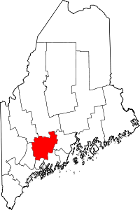 | |
| Towns | ||
| Unorganized territory | ||
| CDPs | ||
| Other villages | ||
Augusta (capital) | |
| Topics |
|
| Society |
|
| Regions | |
| Counties | |
| Cities | |
| Largest towns | |