Edgecomb, Maine
| Edgecomb, Maine | |
|---|---|
| Town | |
 Edgecomb, Maine Location within the state of Maine | |
| Coordinates: 43°58′25″N 69°38′7″W / 43.97361°N 69.63528°WCoordinates: 43°58′25″N 69°38′7″W / 43.97361°N 69.63528°W | |
| Country | United States |
| State | Maine |
| County | Lincoln |
| Incorporated | March 3, 1774 |
| Area[1] | |
| • Total | 20.78 sq mi (53.82 km2) |
| • Land | 18.07 sq mi (46.80 km2) |
| • Water | 2.71 sq mi (7.02 km2) |
| Elevation | 82 ft (25 m) |
| Population (2010)[2] | |
| • Total | 1,249 |
| • Estimate (2012[3]) | 1,243 |
| • Density | 69.1/sq mi (26.7/km2) |
| Time zone | UTC-5 (Eastern (EST)) |
| • Summer (DST) | UTC-4 (EDT) |
| ZIP code | 04556 |
| Area code(s) | 207 |
| FIPS code | 23-22675 |
| GNIS feature ID | 0582462 |
| Website |
edgecomb |
Edgecomb is a town in Lincoln County, Maine, United States. The population was 1,249 at the 2010 census. The town was named for George Edgcumbe, 1st Earl of Mount Edgcumbe, a supporter of the colonists.[4][5] Fort Edgecomb is a Maine State Historic Site.
Geography
According to the United States Census Bureau, the town has a total area of 20.78 square miles (53.82 km2), of which, 18.07 square miles (46.80 km2) of it is land and 2.71 square miles (7.02 km2) is water.[1]
History
Although there is little industry in Edgecomb in 2018, there is a diverse and interesting history of ship building, saw mills, brick yards, farming, landing ocean harvests, rock and felspar mining operations.
Demographics
| Historical population | |||
|---|---|---|---|
| Census | Pop. | %± | |
| 1790 | 755 | — | |
| 1800 | 989 | 31.0% | |
| 1810 | 1,288 | 30.2% | |
| 1820 | 1,629 | 26.5% | |
| 1830 | 1,258 | −22.8% | |
| 1840 | 1,238 | −1.6% | |
| 1850 | 1,231 | −0.6% | |
| 1860 | 1,112 | −9.7% | |
| 1870 | 1,056 | −5.0% | |
| 1880 | 872 | −17.4% | |
| 1890 | 749 | −14.1% | |
| 1900 | 607 | −19.0% | |
| 1910 | 513 | −15.5% | |
| 1920 | 428 | −16.6% | |
| 1930 | 367 | −14.3% | |
| 1940 | 411 | 12.0% | |
| 1950 | 447 | 8.8% | |
| 1960 | 453 | 1.3% | |
| 1970 | 549 | 21.2% | |
| 1980 | 841 | 53.2% | |
| 1990 | 993 | 18.1% | |
| 2000 | 1,090 | 9.8% | |
| 2010 | 1,249 | 14.6% | |
| Est. 2014 | 1,238 | [6] | −0.9% |
| U.S. Decennial Census[7] | |||
2010 census
As of the census[2] of 2010, there were 1,249 people, 523 households, and 356 families residing in the town. The population density was 69.1 inhabitants per square mile (26.7/km2). There were 755 housing units at an average density of 41.8 per square mile (16.1/km2). The racial makeup of the town was 96.2% White, 0.2% African American, 0.4% Native American, 1.5% Asian, and 1.8% from two or more races. Hispanic or Latino of any race were 0.3% of the population.
There were 523 households of which 30.0% had children under the age of 18 living with them, 55.4% were married couples living together, 8.8% had a female householder with no husband present, 3.8% had a male householder with no wife present, and 31.9% were non-families. 26.0% of all households were made up of individuals and 11.1% had someone living alone who was 65 years of age or older. The average household size was 2.37 and the average family size was 2.82.
The median age in the town was 46.4 years. 22.3% of residents were under the age of 18; 4.9% were between the ages of 18 and 24; 20.2% were from 25 to 44; 34.5% were from 45 to 64; and 18% were 65 years of age or older. The gender makeup of the town was 50.1% male and 49.9% female.
2000 census
As of the census[8] of 2000, there were 1,090 people, 466 households, and 328 families residing in the town. The population density was 60.3 people per square mile (23.3/km²). There were 572 housing units at an average density of 31.6 per square mile (12.2/km²). The racial makeup of the town was 98.72% White, 0.28% Native American, 0.18% Asian, and 0.83% from two or more races. Hispanic or Latino of any race were 0.09% of the population.
There were 466 households out of which 29.8% had children under the age of 18 living with them, 60.1% were married couples living together, 6.7% had a female householder with no husband present, and 29.6% were non-families. 25.5% of all households were made up of individuals and 12.7% had someone living alone who was 65 years of age or older. The average household size was 2.34 and the average family size was 2.78.
In the town, the population was spread out with 23.0% under the age of 18, 3.7% from 18 to 24, 25.4% from 25 to 44, 31.5% from 45 to 64, and 16.4% who were 65 years of age or older. The median age was 44 years. For every 100 females, there were 93.6 males. For every 100 females age 18 and over, there were 93.3 males.
The median income for a household in the town was $43,833, and the median income for a family was $49,861. Males had a median income of $32,321 versus $24,474 for females. The per capita income for the town was $23,788. About 2.8% of families and 4.3% of the population were below the poverty line, including 2.0% of those under age 18 and 4.5% of those age 65 or over.
Notable people
- Nancie Atwell, educator and author
- Earl Cunningham, folk art painter
- Lea Wait, author of historical novels for young adults, the Antique Print Mysteries, and the Mainely Needlepoint Mysteries
- Van Reid, author of The Moosepath Saga, including New York Times Notable Book of the Year Cordelia Underwood. Much of the sixth book in the series, Moss Farm takes place near his home in Edgecomb.
References
- 1 2 "US Gazetteer files 2010". United States Census Bureau. Retrieved 2012-12-16.
- 1 2 "American FactFinder". United States Census Bureau. Retrieved 2012-12-16.
- ↑ "Population Estimates". United States Census Bureau. Archived from the original on 2013-06-17. Retrieved 2013-07-06.
- ↑ "Profile for Edgecomb, Maine". ePodunk. Retrieved 2010-05-03.
- ↑ Gannett, Henry (1905). The Origin of Certain Place Names in the United States. Govt. Print. Off. p. 114.
- ↑ "Annual Estimates of the Resident Population for Incorporated Places: April 1, 2010 to July 1, 2014". Retrieved June 4, 2015.
- ↑ "Census of Population and Housing". Census.gov. Archived from the original on May 12, 2015. Retrieved June 4, 2015.
- ↑ "American FactFinder". United States Census Bureau. Archived from the original on 2013-09-11. Retrieved 2008-01-31.
External links
- Town of Edgecomb, Maine
- Maine.gov Profile
- Epodunk Profile
- Facebook page http://facebook.com/edgehiss
- Edgecomb Historical web site http://www.edgecombhistorical.org
Municipalities and communities of Lincoln County, Maine, United States | ||
|---|---|---|
| Towns | 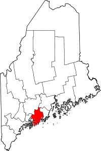 | |
| Plantation | ||
| Gore | ||
| CDPs | ||
| Other villages | ||