Musbury Tor
| Musbury Tor | |
|---|---|
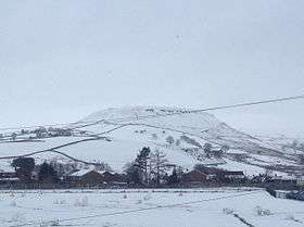 Musbury Tor in the winter of 2015 | |
| Highest point | |
| Elevation | 340.1 m (1,116 ft) [1] |
| Coordinates | 53°40′56″N 2°20′59″W / 53.6821°N 2.3497°WCoordinates: 53°40′56″N 2°20′59″W / 53.6821°N 2.3497°W |
| Geography | |
 Musbury Tor Location in Lancashire 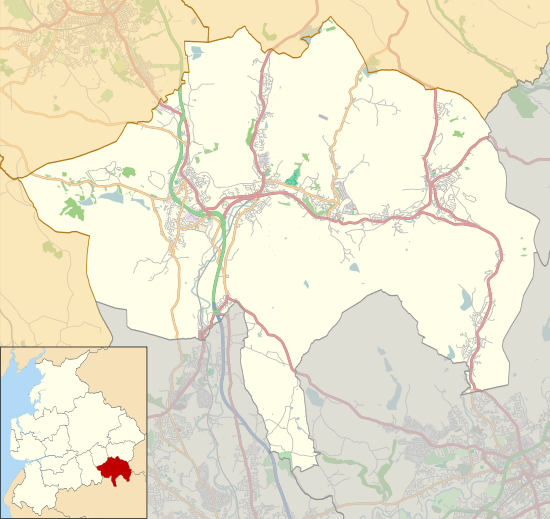 Musbury Tor Location in Rossendale | |
| Location | Lancashire, England |
| OS grid | SD 7699 2068 |
| Topo map | OS Explorer 287 |

Musbury Tor or Tor Hill is a flat-topped hill in south-east Lancashire, England. It overlooks the village of Helmshore and separates Alden Valley to its south and Musbury Valley to its north. Mainly consisting of farmland and pastures, its summit is 340.1 metres (1,116 ft) above sea level. The hill can be seen from much of Helmshore and is often colloquially referred to as ‘the Tor’ by the local population.
Geology
The underlying solid geology of the Rossendale fells is largely formed by the Lower coal measures comprising bedded sandstones, shales and mudstones. Rocks of the Millstone Grit series outcrop above the valley of the River Irwell and cap the hills. Musbury Tor is a perfect example of peneplanation leaving an almost isolated flat-topped hill where the harder Millstone Grit protects the softer underlying shales, leaving the distinctive sharp topography of edges and ledges characteristic of the uplands above the Irwell Valley.[2]
The other small-scale topographic variations such as the undulating hummocky landforms are generally due to the former workings and stone quarries.[3]
History
In the 13th century, Musbury was recorded as part of Tottington township (Salford Hundred) and it is uncertain how it had become part of the Hundred of Blackburn by the 1500s. Possibly the creation of a deer park by Earl of Lincoln around 1304 led to it being included in the Forest of Rossendale.[4] Tor Hill was once the centre of the park with a 4.5 miles (7.2 km) paling enclosing eastern side, and the surrounding ridges of Musbury Heights, Musden Head, and Alden Moor forming the other boundaries. Stretches of the ditches from the enclosure still remain in the Alden and Musbury valleys.[5]
The old township was divided into three portions: Musbury Park, Musden Head (to the south), and the Trippet of Ogden (in the north). This became a civil parish in 1866. In 1894 Musbury became part of the Metropolitan borough of Haslingden.[6][4]
During World War II a Home Guard unit of just four men armed with a single old rifle and six rounds of ammunition climbed each evening to the top of the Tor to man a tiny observation post, often stumbling into bogs and old quarry workings. American GIs also practised paratroop drops, and field exercises with live ammunition, before D-Day, setting up tents and a cookhouse by Great House on the Tor.[7]
In 1949 the Great House Experimental Farm in Helmshore was established by the Ministry of Agriculture on the flat top and southern slopes of Musbury Tor. Important experiments, including many on high-level grain planting and animal husbandry, and the effects of acidity in rain, were carried out. Great House Experimental Farm was closed in 1982, broken up and sold off to private farmers and others.
References
| Wikimedia Commons has media related to Musbury Tor. |
- ↑ Ordnance Survey
- ↑ Trueman, A.E. (1971). Geology and Scenery in England and Wales. Pelican. ISBN 0140201858.
- ↑ A Landscape Strategy for Lancashire: Lancashire Landscape Character Assessment (PDF). Lancashire Country Council Environment Directorate. December 2000. pp. 41–42. Retrieved 1 February 2018.
- 1 2 Farrer; Brownbill, eds. (1911). A History of the County of Lancashire. Victoria County History. 5. p. 150.
- ↑ Historic England. "Monument No. 44446 (44446)". PastScape. Retrieved 11 November 2017.
- ↑ "Musbury Tn/CP through time". A Vision of Britain through Time. GB Historical GIS / University of Portsmouth. Retrieved 1 February 2018.
- ↑ Aspin, Chris (2003). Just a Few Words. Helmshore Local History Society. ISBN 0-906881-12-9.
External links
British Film Institute Amateur footage of the Alden Valley and hay-making at the Great House Experimental Farm (1960).