Bashall Brook
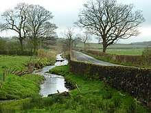
Bashall Brook and the road to Clitheroe
Bashall Brook is a minor river in Lancashire, England. It is 7.09 miles (11.41 km) long and has a catchment area of 6.86 square miles (1,777.68 ha).[1]
The stream rises at Browsholme Tarn on Browsholme Moor descending through Braddup Clough where it collects Elm Clough and flows south and east past Bashall Eaves, meeting Cow Hey Brook before turning northeast to collect Hollins Clough near Back Ridge Farm. It again turns south, passing the Shireburn Caravan Park at Waddington before joining the River Ribble at the Low Moor area of Clitheroe.[2]
References
| Wikimedia Commons has media related to Bashall Brook. |
- ↑ "Bashall Brook". Catchment Data Explorer. Environment Agency. Retrieved 12 November 2017.
- ↑ "103" (Map). Blackburn & Burnley (C2 ed.). 1:50,000. Landranger. Ordnance Survey. 2006. ISBN 978-0-319-22829-6.
| Next confluence upstream | River Ribble | Next confluence downstream |
| Skirden Beck (North) | Bashall Brook | Pendleton Brook (South) |
Coordinates: 53°52′12″N 2°24′57″W / 53.8701°N 2.4157°W
This article is issued from
Wikipedia.
The text is licensed under Creative Commons - Attribution - Sharealike.
Additional terms may apply for the media files.