Lembá District
| Lembá | |
|---|---|
| District | |
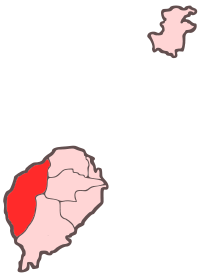 Location within São Tomé and Príncipe | |
| Coordinates: 0°21′N 6°30′E / 0.350°N 6.500°ECoordinates: 0°21′N 6°30′E / 0.350°N 6.500°E | |
| Country | São Tomé and Príncipe |
| Province/Island | São Tomé |
| Seat | Neves |
| Area | |
| • Total | 230 km2 (90 sq mi) |
| Population (2012) | |
| • Total | 15,370 |
| • Density | 67/km2 (170/sq mi) |
| Time zone | UTC+0 (UTC) |
Lembá is a district of São Tomé Province. It is one of the seven districts that make up the equatorial Atlantic island group of São Tomé and Príncipe. It has the westernmost point in the country. It is the second largest in terms of area, covering approximately 230 square kilometers. Its population is 15,370 (2012).[1] The district capital is Neves.
The district are divided into two subdistricts or municipalities: Neves and Santa Catarina.
Population
- 1940 6,885 (11.4% of the national population)
- 1950 6,196 (10.3% of the national population)
- 1960 6,196 (9.7% of the national population)
- 1970 6,206 (8.4% of the national population)
- 1981 7,905 (8.2% of the national population)
- 1991 9,016 (7.7% of the national population)
- 2001 10,696 (7.8% of the national population)[1]
- 2008: 12,331 (est.)[1]
- 2012: 15,370[1]
Settlements
The main settlement is the town Neves. Other settlements are:
- Diogo Vaz
- Generosa
- Lembá (or Lembá Town, Vila de Lembá) - etymology of Angolan origin
- Monte Forte
- Ponta Figo
- Ribeira Funda
- Rosema
- Santa Catarina
- São José
Other settlements
Other hamlets, fractions and sections include:
- Arribana
- Binda - etymology of Angolan origin
- Brigoma - etymology likely of Angolan origin
- Cadão - etymology likely of Angolan origin
- Cascata
- Claudina
- Dona Amélia
- Emília
- Esprainha
- Fortunato
- Frederico
- Vila Graciosa
- João Paulo
- José Luís
- José Luís do Campo
- Maria
- Maria Luísa do Campo
- Monte Carmo
- Monte Figo/Monte Forte
- Morais, Antonio
- Morais, Manuel
- Mulundo - etymology of Angolan origin
- Paga Fogo
- Ponta Furada
- Rebordelo
- Ribeira Palma
- Ribeira Palma na Praia
- Rio Ave
- Rio Leça
- Santa Clotilde
- Santa Irene
- Santa Jenny
- Santa Jenny dos Quatros Caminhos
- Santa Maria
- Santa Teresa
- São João de Lembá
- São Manuel
- São Miguel
- São Oscar
- Sousa, Juliana de
- Vila Sara
Geography
The district has always been completely forested. Agricultural plantations and built up areas also dominates the district. Formerly founded throughout the island, wildlife are still founded in many parts of the district including the southern part.
Most of the populated area are within the Atlantic shore and a few ravines mostly the northern part. Most of the district, notably the south and the east forms a part of the Obo Natural Park.[2] The district has the nation's highest point Pico de São Tomé.
One of the main streams of the district is the Rio Xufexufe. Other streams include Morango. One of the beaches in the district include Palma and Pira.
A few islets are adjacent to the island coast including Gabado located off the beach where Xufexufe empties and Ilhéu de São Miguel.
Fauna
Numerous endemic fauna include the São Tomé fiscal (Lanius newtoni)
Politics
Lembá currently has six seats in the National Assembly.[3]
Sports
The most prominent club of the district is FC Neves, a football (soccer) club. There are also other sports clubs in the district, much of them are based in Neves.
The district is the only one in the country that does not have a single football (soccer) title in championship and cup competitions.
Twin towns - sister cities
References
- 1 2 3 4 INE Archived 2017-02-09 at the Wayback Machine., Evolução da população São-Tomense por localidades, 2001/2012
- ↑ "Tourist Attractions". Sao Tome and Principe Travel and Tourism. Retrieved 15 November 2011.
- ↑ Elections in São Tomé and Principe, African Elections Database.
- ↑ "Historial das Geminações" (in Portuguese). Webpage of the Municipality of Guimarães. Archived from the original on 2007-11-27.
External links

Places adjacent to Lembá District | ||||||||||
|---|---|---|---|---|---|---|---|---|---|---|
| ||||||||||
| Communities | | |
|---|---|---|
| Culture | ||
| Geography | ||
| São Tomé Island | ||
|---|---|---|
| Autonomous Region of Príncipe |
| |