Lamen (island)
 | |
| Geography | |
|---|---|
| Location | Pacific Ocean |
| Coordinates | 16°36′S 168°9′E / 16.600°S 168.150°ECoordinates: 16°36′S 168°9′E / 16.600°S 168.150°E |
| Archipelago | Vanuatu, Shepherd Islands |
| Highest elevation | 34 m (112 ft) |
| Administration | |
| Province | Shefa Province |
| Demographics | |
| Population | 459 (2015) |
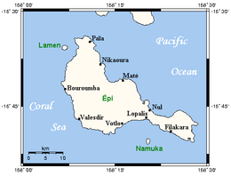
Lamen Island is an inhabited island in Shefa Province of Vanuatu in the Pacific Ocean. The island is a part of Shepherd Islands archipelago.[1]
Geography
Lamen lies 1 km west of the Epi Island.[2] Lamen spans 1.6 km from the north to the south and 1.2 km from the east to the west. The island is flat; its estimated terrain elevation above the sea level is some 34 metres.[3]
Population
As of 2015, the official local population was 459 people in 93 households.[4] Some local people speak Lamenu language.
References
- ↑ "Lamen Island: Vanuatu". Geographic Names. Retrieved 9 August 2018.
- ↑ "Epi". Lonely Planet. Retrieved 9 August 2018.
- ↑ "Lamen, Vanuatu on the Elevation Map". Elevation Map. Retrieved 9 August 2018.
- ↑ "2015 Vanuatu National Population and Households Projections by Province and Islands" (PDF). Vanuatu National Statistics Office. Retrieved 9 August 2018.

This article is issued from
Wikipedia.
The text is licensed under Creative Commons - Attribution - Sharealike.
Additional terms may apply for the media files.