Lake Sevan
| Lake Sevan | |
|---|---|
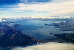 Aerial view of the lake | |
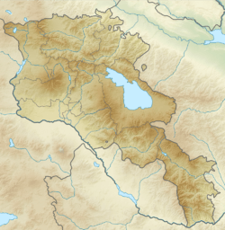 Lake Sevan is located in central eastern Armenia | |
| Location | Gegharkunik Province, Armenia |
| Coordinates | 40°19′N 45°21′E / 40.317°N 45.350°ECoordinates: 40°19′N 45°21′E / 40.317°N 45.350°E |
| Primary inflows | 28 rivers and streams |
| Primary outflows | evaporation: 85–90%, [1] Hrazdan River: 10-15% |
| Basin countries | Armenia |
| Managing agency | Ministry of Nature Protection |
| Max. length | 74 km (46 mi)[2] |
| Max. width | 32 km (20 mi)[2] |
| Surface area | 1,238.8 km2 (478.3 sq mi)[3] |
| Average depth | 26.8 m (88 ft)[3] |
| Max. depth | 79.4 m (260 ft)[3] |
| Water volume | 33.2 km3 (26,900,000 acre⋅ft)[3] |
| Salinity | 0.7%[4] |
| Surface elevation | 1,900 m (6,200 ft) (2012)[5] |
| Islands | formerly 1 (now a peninsula) |
| Sections/sub-basins | 2 (Major Sevan, Minor Sevan) |
| Settlements | Gavar, Sevan, Martuni, Vardenis |
IUCN Category II (National Park) | |
| Official name | Sevan National Park |
| Designated | 14 March 1978 |
| Official name | Lake Sevan |
| Designated | 7 June 1993 |
| Reference no. | 620[6] |
Lake Sevan (Armenian: Սևանա լիճ) is the largest body of water in Armenia and the Caucasus region. It is one of the largest freshwater high-altitude (alpine) lakes in Eurasia.[7] The lake is situated in Gegharkunik Province, at an altitude of 1,900 m (6,234 ft) above sea level. The total surface area of its basin is about 5,000 km2 (1,900 sq mi), which makes up 1⁄6 of Armenia's territory.[7] The lake itself is 1,242 km2 (480 sq mi), and the volume is 32.8 km3 (7.9 cu mi). It is fed by 28 rivers and streams. Only 10% of the incoming water is drained by the Hrazdan River, while the remaining 90% evaporates.
The lake provides some 90% of the fish and 80% of the crayfish catch of Armenia.[8] Sevan has significant economic, cultural, and recreational value. Its only island (now a peninsula) is home to a medieval monastery.
Sevan was heavily exploited for irrigation of the Ararat plain and hydroelectric power generation during the Soviet period. Consequently, its water level decreased by around 20 m (66 ft) and its volume reduced by more than 40%. Two tunnels were later built to divert water from highland rivers, which halted its decline and its level began rising. Before human intervention dramatically changed the lake's ecosystem, the lake was 95 m (312 ft) deep, covered an area of 1,416 km2 (547 sq mi) (5% of Armenia's entire area), and had a volume of 58.5 km3 (14.0 cu mi). The lake's surface was at an altitude of 1,916 m (6,286 ft) above sea level.[3]
Etymology
The scholarly consensus is that the word Sevan originated from the Urartian word su(i)n(i)a, usually translated as "lake".[9][10][11] The term is found on an 8th-century BC cuneiform inscription by the Urartian king Rusa I, found in Odzaberd, on the southern shore of the lake.[12] Per folk etymology, Sevan is either a combination of sev ("black") + Van (i.e., Lake Van) or sev ("black") and vank’ ("monastery").[13][12] Russian and European sources of the 19th and early 20th century sometimes referred to the lake as Sevanga or Sevang.[14][15][16][17][18][19] It is the Russified version of the Armenian sev vank’ ("black monastery")[20] or, possibly, derives from the Armenian phrase սա է վանքը sa ē vank'ə ("this is the monastery").[21]
Since antiquity up to the Middle Ages,[22] Sevan was mostly known as a sea and referred to in Armenian as the Sea of Gegham[23][24] (classical Armenian: ծով Գեղամայ, tsov Geghamay).[lower-alpha 1] In classical antiquity, the lake was known as Lychnitis (Ancient Greek: Λυχνῖτις).[27][28][29] The historic Georgian name of the lake is Gelakuni (გელაქუნი).[30][31][lower-alpha 2] The name Gokcha (Turkish: Gökçe,[33][34] Azerbaijani: Göyçə, "blue water")[35] often appeared in Russian and European sources during the 19th and early 20th century.[14][15][27]
Significance
Cultural
Along with Lake Van and Lake Urmia, Sevan is considered one of the three great "seas"[36] of historic Armenia.[37][38] It is the only one within the boundaries of present-day Republic of Armenia, while the other two are located in Turkey and Iran, respectively. Lake Sevan is considered the "jewel" of Armenia[39][40][41] and is "recognized as a national treasure" in the country.[42] The 2001 Law on Lake Sevan defines the lake as "a strategic ecosystem valuable for its environmental, economical, social, scientific, cultural, aesthetic, medical, climatic, recreational, and spiritual value."[43] Naturalist and traveler Friedrich Parrot, best known for ascending Mount Ararat in 1829 for the first time in history, wrote that,
[the] sea enjoys a high celebrity for sanctity with all Armenians, far and near, on account of the many old, and now partly deserted religious houses on its shores; and with all the rest of the natives for its wonderful stores of fish, of which salmon-trout is peculiarly esteemed, being dried and carried to great distances for sale."[44]
Economic
It is important for the Armenian economy: being the main source of irrigation water, Sevan provides low-cost electricity, fish, recreation, and tourism.[7]
Origin
Sevan originated during the early Quaternary when a Palaeo-Sevan, ten times larger than the present lake, came into existence by tectonic formation.[4] The current lake was formed some 25 to 30 thousand years ago.[2]
Human intervention
Exploitation and reduction
Background
Sevan was recognized as being a major potential water resource in the 19th century. Its high attitude location relative to the fertile Ararat plain and limited energy resources attracted engineers to explore ways of usage of the lake's water. In his 1910 book, Armenian engineer Sukias Manasserian proposed to use Sevan's water for irrigation and hydroelectric power generation. He proposed draining the lake by 50 m (160 ft). Major Sevan would completely dry out, while Minor Sevan would have a surface area of 240 km2 (93 sq mi).[45]
Implementation
Manasserian's proposal was adopted by the Soviet authorities in the 1930s when, under Joseph Stalin, the country was undergoing rapid industrialization. Works on the project started in 1933. The riverbed of Hrazdan was deepened thorough excavation. A tunnel was bored around 40 metres (130 ft) under the lake's surface. The tunnel was completed in 1949 and thereafter the Sevan's level began to drop significantly, at a rate over 1 metre (3 ft) per year. The water was used for irrigation and the Sevan–Hrazdan Cascade of six hydroelectric power stations on Hrazdan River.[45][46]
| Indices | 1936 | 2000 | Decrease |
|---|---|---|---|
| Height above sea level, m | 1915.97 | 1896.65 | -19.32 |
| Lake surface, km2 | 1416.2 | 1238.8 | 12.5% |
| Mean depth, m | 41.3 | 26.8 | 35% |
| Maximum depth, m | 98.7 | 79.7 | 19% |
| Water amount, km3 | 58.48 | 33.20 | 43.2% |
Effects
During the second half of the 20th century, the ecological condition of Lake Sevan underwent tangible changes and vast degradation due to reduced water level, increased eutrophication, and detrimental impact of human activity on the biological diversity of the lake. According to Babayan et al. the lake level dropped by 19.88 m (65.2 ft) by 2002, while the volume decreased by 43.8% (from 58.5 to 32.9 km3 [14.0 to 7.9 cu mi]). Due to the water level decrease, the quality of the water deteriorated, natural habitats were destroyed that meant loss of biodiversity.[45] Vardanian wrote that drop of the lake level and the economic development in the basin brought about the change in hydro-chemical regime of the lake. The quality of the water deteriorated, water turbidity increased. The inner circulation of the water constituents as well as the circulation of the biological substances altered.[47]
Reversal and recovery
According to Babayan et al. "by the 1950s it had become evident that the ecological and economic consenquences of extensive exploitation of the water of Lake Sevan were too undesirable to continue in the same way."[45]
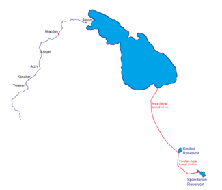
Arpa–Sevan tunnel
In 1964 a project began to divert the Arpa River (from a reservoir near Kechut) through a 49 km (30 mi) long tunnel to the lake near Artsvanist.[48][49] The tunnel, called Arpa–Sevan, was completed in 1981. It brings up to 200 million cubic metres (7.1 billion cubic feet) of water to Sevan per year.[50]
It is estimated, that due to climate change by year 2030 outflow of Arpa river will decrease by 22%. [51]
Vorotan–Arpa tunnel
Since the water level in the lake did not rise as fast and as much, on 20 April 1981 the Council of Ministers of the Soviet Union made a decision for the construction of the Vorotan–Arpa tunnel.[52] This 21.6 km (13.4 mi) long tunnel was begun from the Spandarian Reservoir on the Vorotan River further south from Kechut.[53] Due to the Nagorno-Karabakh conflict and the 1988 earthquake in northwestern Armenia construction was halted. The tunnel was inaugurated on 26 April 2004.[54] The Vorotan–Arpa tunnel brings an additional 165 million cubic metres (5.8 billion cubic feet) to the lake annually.[50][52]
Increase in water level
After the construction of the two tunnels the water level began rising significantly since the mid-2000s. In 2007 it was reported that the water level had risen by 2.44 metres (8.0 ft) in the previous six years.[55] It reached 1,900.04 m (6,233.7 ft) in October 2010. The government committee on Sevan forecasts that the level will reach 1,903.5 m (6,245 ft) by 2029.[56]
Population
.svg.png)
The Gegharkunik Province, which roughly corresponds to the lake's basin, had a de facto population of 211,828 according to the 2011 Armenian census. The largest settlements in the province are: Gavar (20,765), Sevan (19,229), Martuni (12,894), Vardenis (12,685), Vardenik (9,880), Yeranos (6,119), Chambarak (5,660), Lchashen (5,054), Tsovagyugh (4,189).[57]
Tourism
Beaches
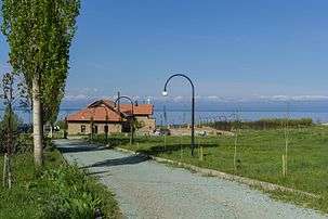
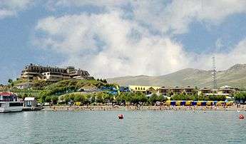
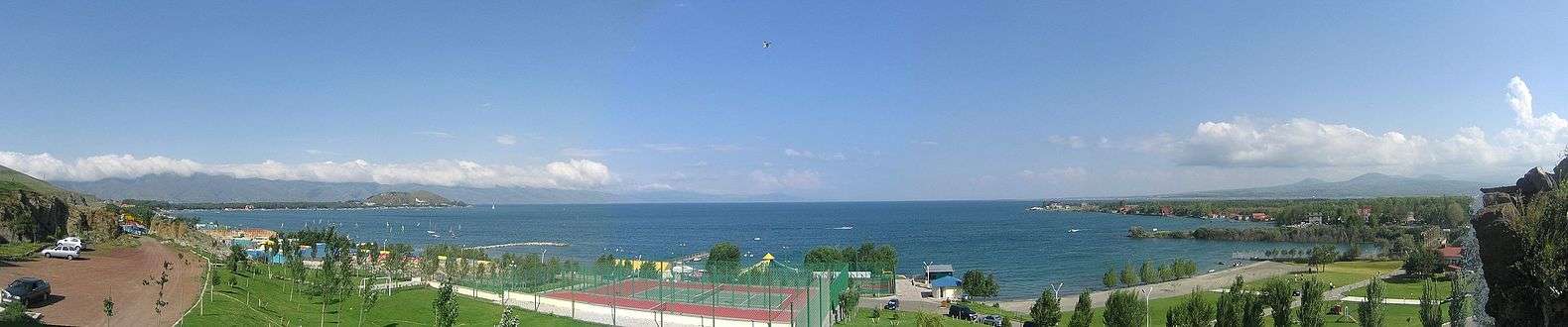
Lake Sevan has the only beaches in Armenia.[58] They are a popular destination for the Armenians.[59] Sevan's beaches provide a unique experience within the landlocked country for Armenians. The beaches adjacent to hotels are usually privatized.[58] Numerous beaches are located along the entire lake shore. The most popular of them is a 2.5-kilometre (1 1⁄2 mi) stretch on the northern shore, extending northwest from the peninsula. Resorts include Harsnaqar Hotel, Best Western Bohemian Resort, and numerous smaller facilities. Activities include swimming, sunbathing, jet skiing, windsurfing, and sailing. The area also includes numerous campgrounds and picnic areas for daytime use. A less-developed beach destination stretches along the eastern shore from Tsovagyugh to Shorzha, with numerous small cabins at Shorzha. The Avan Marak Tsapatagh Hotel, a Tufenkian Heritage Hotel, is a luxury resort on the undeveloped southeastern shore of the lake near Tsapatagh.
The Armenian government pledged to "reduce the growing commercialization of rest at Lake Sevan that makes it unaffordable for most citizens struggling to find other beach options during hot Armenian summers."[60] In 2011 the government established public beaches in the Sevan National Park’s recreational zone. The first two public beaches were opened in July. Some 100,000 people visited the public beaches in summer of 2011. The beaches have free parking space, children’s and sports playgrounds, toilets, medical aid stations, and rescue services. They are also equipped with beach couches.[61] By 2014, the number of public beaches reached 11. Some 200,000 people took holiday there in 2014.[62]
 Tufenkian Avan Marak Tsapatagh Hotel (Tsapatagh)
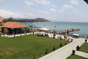 Best Western Bohemian Resort
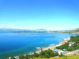 The beach of Sevan town
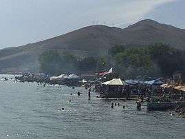
 The Harsnaqar Hotel Complex
Sites of interest
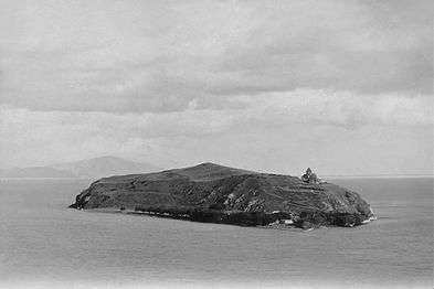
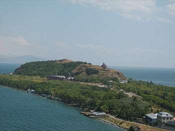
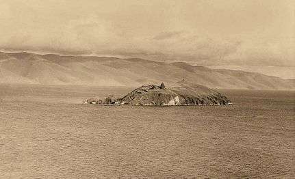
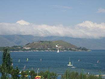
The most famous cultural monument is the Sevanavank monastery located on the peninsula, which was until the mid-20th century an island. Another prominent monastery at the western shore is Hayravank, and further south, in the village of Noratus, is a field of khachkars, a cemetery with about 900 khachkars of different styles. Additional khachkars are found at Nerkin Getashen on the south coast.
Island
.jpg)
Fauna
Fish
Sevan trout (Salmo ischchan) is an endemic species of the lake, but it is endangered as some competitors were introduced into the lake, including common whitefish (Coregonus lavaretus) from Lake Ladoga, goldfish (Carrasius auratus), and crayfish (Astacus leptodactylus). If the Sevan trout is likely to become extinct in its "home" lake, it seems that it will survive in Issyk-Kul Lake (Kyrgyzstan) where it was introduced in the 1970s.
Due to anthropogenic impact, changes have occurred in all the biological components of the lake, including bacteria, benthos, and of course fish. Thus, the benthic mass increased tenfold in 1940, due to oligochetes and chrinomices. Today, the former prevail and multiply the oxygen-rich residue at the bottom of the lake.
The bojak and winter bakhtak species of the Sevan-endemic trout have already disappeared. The summer bakhtak occurs rarely; the gegharkuni is still capable of reproducing naturally. In 1980s, the quantity of Sevan koghak significantly decreased. Numerous reasons for this have been identified:
- The level of the water was lowered, the patches of rivers changed, and the trout (gegharkuni and Aestivalis species) lost their natural spаwning places. Changes in the areas near the shore (mossing, disappearance of macrophyte plants) also had a negative impact on the trout lays. The trout spawn only in certain areas, with oxygen-rich underground water at the depth of 25–30 m (80–100 ft).
- Deoxidization of the bottom is extremely detrimental for salmon, which are used to more than 4 mg/l of O2.
- In the last 10 years, poaching rapidly increased, which significantly reduced the number of fish in the lake.
Birds
The bird fauna of the lake and its vicinity makes over 200 species, out of which 95 species are breeding.[63] The lake is an important breeding ground for the Armenian gull (Larus armenicus) with about 4,000–5,000 pairs. During migration the Lake is visited by wide variety of birds including raptors, such as Montagu's harrier (Circus pygargus) and Steppe eagle (Aquila nipalensis), waterbirds such as red-crested pochard (Netta rufina) and ferruginous duck (Aythya nyroca), while during the wintering period the lake hosts another set of species such as Bewick's swan (Cygnus columbianus) and great black-headed gull (Larus ichthyaetus). Sometimes the lake is visited by very rare Armenian migrant lesser white-fronted goose (Anser erythropus).
Other species
The mouflon are suffering a great population decline due to poaching and habitat loss. The Sevan trout, which made up 30% of the fish in Lake Sevan, have virtually disappeared. Another endangered visitor to the lake is the Armenian leopard or panther (Panthera pardus tullianus).
References
- ↑ modern Armenian: Գեղամա ծով, Geghama tsov[25] The name is mentioned by several medieval Armenian historians, including in Movses Khorenatsi's History of Armenia.[26]
- ↑ It is called "Lake Ereta" by Leonti Mroveli in The Georgian Chronicles drawing from the name of its old inhabitants (i.e. before the fall of Urartu), the Èrs.[32]
- ↑ EEA 2015, p. 9.
- 1 2 3 EEA 2015, p. 7.
- 1 2 3 4 5 6 Vardanian 2009, p. 78.
- 1 2 O'Sullivan, Patrick; Reynolds, C. S., eds. (2008). The Lakes Handbook: Limnology and Limnetic Ecology. John Wiley & Sons. p. 57. ISBN 9780470999264.
- ↑ "Water level of Armenia's Lake Sevan rises faster than specified law – official". news.am. 2 March 2013.
- ↑ "Lake Sevan". Ramsar Sites Information Service. Retrieved 25 April 2018.
- 1 2 3 Babayan et al. 2006, p. 347.
- ↑ Babayan et al. 2006, p. 348.
- ↑ Севан от урартск. суниа — «озеро» Pospelov, Evgeniy (1998). Географические названия мира [Geograficheskie Nazvaniia Mira] (Geographic names of the world) (in Russian). Moscow. p. 160. ISBN 5-89216-029-7.
- ↑ Kirillova, Yulia M. (1969). Армения—открытый музей (in Russian). Iskusstvo. p. 28.
Урартийцам обязано своим происхождением слово «Севан» (от «Сиунна» — страна озерная).
- ↑ Murzayev, Ed. M. (1984). Словарь народных географических терминов (in Russian). Mysl. p. 112.
Вне ряда Севан — озеро в Армении, имя которого восходит к урартскому гумна — « озеро».
- 1 2 Avetisyan 1979, pp. 86-87.
- ↑ René Grousset. The Empire of the Steppes: A History of Central Asia, Rutgers University Press, 1970, p. 348, ISBN 0-8135-1304-9
- 1 2

- 1 2 Massalski, Władysław (1892). "Гокча". Brockhaus and Efron Encyclopedic Dictionary Volume X (in Russian). pp. 39–40.
- ↑ Semenov, Petr Petrovič (1873). Geografičesko-statističeskij slovarʹ Rossijskoj Imperii: Pavasterort - Sjatra-Kasy, Volume 4 (in Russian). Bezobrazov i komp. p. 532.
Севанга, озеро, Эриванской г-іи, Новобаязетскаго у.; см. Гокчинское.
- ↑ Nadezhdin, P. (1869). Природа и люди на Кавказѣ и за Кавказом (in Russian). Saint Petersburg: V. Demakov Typography. p. 230.
Гёг-чайское озеро (синяя вода), по-армянски Севанга, есть самое значительное въ цѣломъ Закавказскомъ краѣ...
- ↑ Lynch, H. F. B. (1896). "The Ascent of Mount Ararat". Scribner's Magazine. 19: 215.
Ararat rises from the table-land of Armenia between the Black and Caspian Seas in the country comprised within a triangle between the lakes of Sevanga, Urumia, and Van.
- ↑ Francis Rawdon Chesney (1850). The expedition for the survey of the rivers Euphrates and Tigris. London: Longman, Brown, Green, and Longmans. p. 763.
Ghokhcha, Gouktcha, or Sevanga, lake (in Armenia)
- ↑ Baer, Karl M.; Lukina, Tatyana A. (1984). Каспийская экспедиция К.М. Бэра, 1853-1857 гг: дневники и материалы [Caspiran Encyclopedia of K. M. Baer, 1853-1857: Diary and Materials] (in Russian). Leningrad: Nauka. p. 532.
Севанг (арм. сев-ванг — черный монастырь)
- ↑ Ivanovsky, A. A. (1911). По Закавказью. археологические наблюдения и исследования 1893, 1894 и 1896 гг. [Through the Transcaucasia: archeological observations and studies in 1893, 1894, and 1896] (in Russian). Moscow: Mamontov Typography. p. 30.
- ↑ Adalian, Rouben Paul (2010). Historical Dictionary of Armenia. Lanham, Maryland: Scarecrow Press. p. 540. ISBN 978-0-8108-7450-3.
- ↑ "Geographic characteristic of the Republic of Armenia" (PDF). armstat.am. National Statistical Service of Republic of Armenia.
Sevan is adornment of nature of the Republic of Armenia (the ancient name is Geghama sea).
- ↑ Avakian, Arra S. (1998). "Van". Armenia: A Journey Through History. Electric Press. p. 3. ISBN 978-0-916919-24-5.
...Sevan (Geghama)...
- ↑ Avetisyan 1979, p. 310: "Գեղամա ծով"
- ↑ Translated as "lake of Geḷam" by Robert W. Thomson, see Thomson, Robert W. (1980). Moses Khorenats'i History of the Armenians (2nd ed.). Harvard University Press. p. 185.
- 1 2 Bryce, James (1878). Transcaucasia and Ararat: Being Notes of a Vacation Tour in Autumn of 1876 (3rd ed.). London: Macmillan and Co. p. 168.
...the lake which the Russians call Goktcha (a corruption of the Tartar name, which means blue lake), and the natives Sevan, the Lychnitis of the ancients...
- ↑ Toumanoff, Cyrille (1963). Studies in Christian Caucasian history. Georgetown University Press. p. 33.
...Thospitis, Mantiane, and Lychnitis, or, as they are now called, Van, Urmia, and Sevan...
- ↑ Smith, William (1854). "LYCHNI´TIS". Dictionary of Greek and Roman Geography. London. view online
- ↑ "Gruusia / Georgian". eki.ee. Institute of the Estonian Language.
Gelakunis ţba / გელაქუნის ტბა (Sewan) h2 AM
- ↑ "გელაქუნი [gelakuni]" (in Georgian). National Parliamentary Library of Georgia.
- ↑ Jaimoukha, Amjad M. (2005). The Chechens: A Handbook. Psychology Press. p. 29. ISBN 9780415323284.
- ↑ Bosworth, C. E. (1986). "Arrān". Encyclopædia Iranica.
...Lake Sevan, later Turkish Gökçe...
- ↑ Woods, John E. (1999). The Aqquyunlu: Clan, Confederation, Empire. 178: University of Utah Press. ISBN 9780874805659.
...Lake Gökçe (Sevan) in Armenia...
- ↑ Allen, William Edward David; Muratoff, Paul (1953). Caucasian Battlefields: A History of the Wars on the Turco-Caucasian Border 1828-1921. Cambridge University Press. p. 9.
...Lake Sevan (A. Sevan; T. Gök-çay; 'Blue water')...
- ↑ Woolf, Greg (2007). Ancient civilizations: the illustrated guide to belief, mythology, and art. Barnes & Noble. p. 129. ISBN 9781435101210.
Lakes Sevan, Urmia, and Van are considered by Armenians to be their "three seas"...
- ↑ Papajian, Sarkis (1974). A brief history of Armenia. Fresno, California: Armenian Evangelical Union of North America. p. 2.
Historic Armenia has three great lakes: Sevan, Van and Urmia.
- ↑ Mouradian, George (1995). Armenian infotext. Bookshelf Publishers. p. 185. ISBN 9780963450920.
Urmia, Lake, one of the three large lakes of ancient Armenia, the other two being Lake Van and Lake Sevan.
- ↑ Krikorian, Robert; Masih, Joseph (1999). Armenia: At the Crossroads. Routledge. p. 2. ISBN 9781134412181.
The water level of Lake Sevan, the jewel of Armenia, was dropping precipitously...
- ↑ Mkrtchyan, Gayane (27 December 2013). "Lake Concerns: Group warns that "Armenia's Jewel" could be endangered by carelessness". ArmeniaNow.
- ↑ Johnson, Jerry L. (2000). Crossing Borders--confronting History: Intercultural Adjustment in a Post-Cold War World. University Press of America. p. 72. ISBN 9780761815365.
Armenians consider Lake Sevan a jewel of their country.
- ↑ Babayan et al. 2006, p. 357.
- ↑ "Հայաստանի Հանրապետության օրենքը Սևանա լճի մասին [Republic of Armenia Law on Lake Sevan]". parliament.am (in Armenian). 15 March 2001.
- ↑ Parrot, Friedrich (2016) [1846]. Journey to Ararat. Translated by William Desborough Cooley. Introduction by Pietro A. Shakarian. London: Gomidas Institute. p. 75. ISBN 978-1909382244.
- 1 2 3 4 Babayan et al. 2006, p. 354.
- ↑ Vardanian 2009, p. 79.
- ↑ Vardanian 2009, p. 83.
- ↑ http://arpa-sevan.am/en/1961-1981-the-complex-of-hydraulic-works-for-transfer-of-the-arpa-and-yeghegis/
- ↑ http://arpa-sevan.am/en/1968-1980-construction-of-tunnel-no-2-and-of-arpa-sevan-conduit/
- 1 2 Babayan et al. 2006, p. 356.
- ↑ "Climate change impact on water resources and crop production in Armenia". Agricultural Water Management. 161: 86–101. 2015-11-01. doi:10.1016/j.agwat.2015.07.004. ISSN 0378-3774.
- 1 2 Makaryan, Marieta (27 April 2004). "Ավարտվեց "Որոտան-Արփա" թունելի շինարարությունը [Construction of "Vorotan-Arpa" tunnel completed]". Azg (in Armenian).
- ↑ http://arpa-sevan.am/en/1995-2003-complex-of-hydraulic-structures-for-diversion-of-the-vorotan-river-runoff-to-the-basin-of-the-arpa-river/
- ↑ Ավարտվեց «Որոտան-Արփա» թունելի շինարարությունը. Azg (in Armenian). 27 April 2004. Retrieved 7 June 2013.
- ↑ Harutyunyan, Arpi (29 June 2007). "Sevan Rising: Lake Sevan's recovery quicker than expected". ArmeniaNow.
- ↑ Shoghikyan, Hovhannes (6 October 2010). "Սեւանա լճի մակարդակը այս տարի բարձրացել է 56 սանտիմետրով". azatutyun.am (in Armenian). Radio Free Europe/Radio Liberty.
- ↑ "ՀՀ Գեղարքունիքի մարզի առկա և մշտական բնակչությունն ըստ վարչատարածքային միավորների և սեռի" (PDF). armstat.am (in Armenian).
- 1 2 Holding, Deirdre (2014). Armenia: with Nagorno Karabagh (4th ed.). Bradt Travel Guides. p. 202. ISBN 9781841625553.
- ↑ Bonner, Raymond (9 August 1993). "Yerevan Journal; Landlocked and Alone, Armenia Fears the Winter". The New York Times.
The beach at Lake Sevan, 40 miles east the capital, would normally be packed this time of the year.
- ↑ Chilingarian, Elina (8 July 2011). "'Public' Beaches Available at Armenia's Lake". azatutyun.am. Radio Free Europe/Radio Liberty.
- ↑ "Available 'Blue Pearl': Public beaches proved popular with Lake Sevan holidaymakers". ArmeniaNow. 30 September 2011.
- ↑ "The holiday season opened along with the public beaches of Sevan Lake". Public Television of Armenia. 5 July 2015.
- ↑ Aghababyan K., Khanamirian G. 2017. Baseline study of the Birds at Lake Sevan for further monitoring. Lake Sevan National Park.
Bibliography
- Vardanian, Trahel (2009). "The Hydro-chemical changes of Lake Sevan after the artificial lowering o the water level". In Bahadir, Ali Mufit; Duca, Gheorghe. The Role of Ecological Chemistry in Pollution Research and Sustainable Development. Springer Science & Business Media. pp. 77–84. ISBN 9789048129010.
- Babayan, Araik; Hakobyan, Susanna; Jenderedjian, Karen; Muradyan, Siranush; Voskanov, Mikhail (2006). "Lake Sevan: Experience and Lessons Learne Brief" (PDF). ilec.or.jp. International Lake Environment Committee Foundation. pp. 347–362. Archived from the original (PDF) on March 14, 2012.
- "Շրջակա միջավայրի տեղեկատվական միասնական համակարգ Սևանա լճի համար" (in Armenian). Yerevan: European Environment Agency Shared Environment Information System. 2015. Archived from the original on 12 November 2015.
- Avetisyan, Kamsar (1979). Հայրենագիտական Էտյուդներ [Notes on Armenian Studies] (in Armenian). Yerevan: Sovetakan grogh.