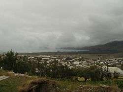
Lchashen
Coordinates: 40°31′13″N 44°55′51″E / 40.52028°N 44.93083°E
| Lchashen Լճաշեն | |
|---|---|
 Lchashen | |
 Lchashen Լճաշեն | |
| Coordinates: 40°31′13″N 44°55′51″E / 40.52028°N 44.93083°E | |
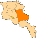
| Country | Armenia |
| Province | Gegharkunik |
| Population (2010) | |
| • Total | 5,054 |
Lchashen (Armenian: Լճաշեն; until 1946 Ordaklu) is a major village in the Gegharkunik Province of Armenia. The settlement dates back to the 3rd millennium BC. It has a 13th-century church, an Urartian Iron Age fortress and a Bronze Age cemetery.
See also
References
- Lchashen at GEOnet Names Server
- World Gazeteer: Armenia – World-Gazetteer.com
- Report of the results of the 2001 Armenian Census, National Statistical Service of the Republic of Armenia
- Kiesling, Brady (2005), Rediscovering Armenia: Guide, Yerevan, Armenia: Matit Graphic Design Studio
- Brady Kiesling, Rediscovering Armenia, p. 43; original archived at Archive.org, and current version online on Armeniapedia.org.
This article is issued from
Wikipedia.
The text is licensed under Creative Commons - Attribution - Sharealike.
Additional terms may apply for the media files.