Lake Van
| Lake Van | |
|---|---|
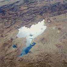
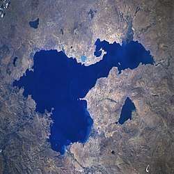 From space, September 1996 (top of image is roughly northwest) | |
| Coordinates | 38°38′N 42°49′E / 38.633°N 42.817°ECoordinates: 38°38′N 42°49′E / 38.633°N 42.817°E |
| Type | Tectonic lake, saline lake |
| Primary inflows | Karasu, Hoşap, Güzelsu, Bendimahi, Zilan and Yeniköprü streams[1] |
| Primary outflows | none |
| Catchment area | 12,500 km2 (4,800 sq mi)[1] |
| Basin countries | Turkey |
| Max. length | 119 km (74 mi) |
| Surface area | 3,755 km2 (1,450 sq mi) |
| Average depth | 171 m (561 ft) |
| Max. depth | 451 m (1,480 ft)[2] |
| Water volume | 607 km3 (146 cu mi)[2] |
| Shore length1 | 430 km (270 mi) |
| Surface elevation | 1,640 m (5,380 ft) |
| Islands | Akdamar, Çarpanak (Ktuts), Adır (Lim), Kuş (Arter) |
| Settlements | Van, Tatvan, Ahlat, Erciş |
| 1 Shore length is not a well-defined measure. | |
Lake Van (Turkish: Van Gölü, Armenian: Վանա լիճ, Vana lič̣, Kurdish: Gola Wanê), the largest lake in Turkey, lies in the far east of that country in the provinces of Van and Bitlis. It is a saline soda lake, receiving water from numerous small streams that descend from the surrounding mountains. Lake Van is one of the world's largest endorheic lakes (having no outlet) – a volcanic eruption blocked the original outlet from the basin in ancient times. Although Lake Van has an altitude of 1,640 m (5,380 ft) in a region with harsh winters, its high salinity prevents most of it from freezing, and even the shallow northern section freezes only rarely.[3]
Hydrology and chemistry
Lake Van is 119 kilometres (74 mi) across at its widest point, averaging a depth of 171 metres (561 ft) with a maximum recorded depth of 451 metres (1,480 ft).[2] The lake surface lies 1,640 metres (5,380 ft) above sea level and the shore length is 430 kilometres (270 mi). Lake Van has an area of 3,755 km2 (1,450 sq mi) and a volume of 607 cubic kilometres (146 cu mi).[2]
The western portion of the lake is deepest, with a large basin deeper than 400 m (1,300 ft) lying northeast of Tatvan and south of Ahlat. The eastern arms of the lake are shallower. The Van-Ahtamar portion shelves gradually, with a maximum depth of about 250 m (820 ft) on its northwest side where it joins the rest of the lake. The Erciş arm is much shallower, mostly less than 50 m (160 ft), with a maximum depth of about 150 m (490 ft).[4][5]
The lake water is strongly alkaline (pH 9.7–9.8) and rich in sodium carbonate and other salts, which are extracted by evaporation and used as detergents.[6]
Geology
Lake Van is primarily a tectonic lake, formed more than 600,000 years ago by the gradual subsidence of a large block of the earth's crust due to movement on several major faults that run through this portion of Eastern Anatolia. The lake's southern margin marks the boundary between metamorphic rocks of the Bitlis Massif and volcanic strata from the Neogene and Quaternary periods. The deep, western portion of the lake is a dome-shaped basin lying in a tectonic depression formed by a combination of normal and strike-slip faulting and thrusting.[7]
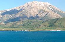
The lake's proximity to the Karlıova Triple Junction has resulted in fluids from the Earth's mantle accumulating in the strata beneath Lake Van, driving some of its geological evolution.[7] Dominating the lake's northern shore is the stratovolcano Mount Süphan. The broad crater of a second, dormant volcano, Mount Nemrut, lies close to the western tip of the lake. There is hydrothermal activity throughout the region.[7]
For much of its history, Lake Van has had an outlet towards the southwest. However, the level of this threshold has varied over time, as the lake has been blocked by successive lava flows from Nemrut volcano westward towards the Muş Plain. This threshold has then been lowered at times by erosion.
Bathymetry
The first acoustic survey of Lake Van was performed in 1974.[4][8] Building on this, Kempe and Degens identified three distinct physiographic provinces within the lake: a lacustrine shelf (27% of the lake area) that extends from the shore to a clear gradient change; a steeper lacustrine slope (63% of the area); and a deep, relatively flat basin province (10% of the area) in the western center of the lake.[9] The deepest part of the lake is the Tatvan basin, which is almost completely bounded by faults.[8]
Prehistoric lake levels
.png)
The presence of terraces above the current lake level has long been recognized. On a visit in 1898, geologist Felix Oswald noted three raised beaches at 15, 40 and 100 feet (5, 12 and 30 meters) above the lake level of the time, as well as recently drowned trees.[10] Research in the past century has identified many similar terraces, and the lake's level has fluctuated significantly during that time.
Because Lake Van has no outlet, the present-day level is very dependent on the balance between inflow and evaporation.
The water level of the lake has often altered dramatically. Investigation by Degens and others in the early 1980s determined that the highest lake levels (72 metres (236 ft) above the current height) had been during the last ice age, about 18,000 years ago. Approximately 9,500 years ago there was a dramatic drop to more than 300 metres (980 ft) below the present level. This was followed by an equally-dramatic rise around 6,500 years ago.[2]
As a deep lake with no outlet, Lake Van has accumulated great amounts of sediment washed in from surrounding plains and valleys, and occasionally deposited as ash from eruptions of nearby volcanoes. This layer of sediment is estimated to be up to 400 metres (1,300 ft) thick in places, and has attracted climatologists and vulcanologists interested in drilling cores to examine the layered sediments.
In 1989 and 1990, an international team of geologists led by Dr. Stephan Kempe from the University of Hamburg (now Professor at the Technische Universität Darmstadt) retrieved ten sediment cores from depths up to 446 m (1,463 ft). Although these cores only penetrated the first few meters of sediment, they provided sufficient varves to give proxy climate data for up to 14,570 years BP.[11]
A team of scientists headed by palaeontologist Professor Thomas Litt at the University of Bonn has applied for funding from the International Continental Scientific Drilling Program (ICDP) for a new, deeper-drilling project to examine the lake's sediments. Litt expects to find that "Lake Van stores the climate history of the last 800,000 years—an incomparable treasure house of data which we want to tap for at least the last 500,000 years."[12] A test drilling in 2004 detected evidence of 15 volcanic eruptions in the past 20,000 years.
Recent lake level change
Similar-but-smaller fluctuations have been seen recently. The level of the lake rose by at least three metres during the 1990s, drowning much agricultural land, and (after a brief period of stability and then retreat) seems to be rising again. The level rose approximately two meters in the ten years immediately prior to 2004.[1]
Climate
Lake Van is situated in the highest and largest region of Turkey, which has a harsh continental climate. Average temperatures in July are between 22 and 25 °C, and in January between −3 °C to −12 °C. In particularly-cold winter nights the temperature reaches −30 °C. Lake Van mitigates the climate somewhat, so in the city of Van, on the shore of the lake, the average temperature in July is 22.5 °C, and in January −3.5 °C. The average annual rainfall in the basin of Lake Van, ranges from 400 to 700 mm.[13][14]
Ecology
The only fish known to live in the brackish water of Lake Van is Chalcalburnus tarichi or Pearl Mullet (Turkish: inci kefalı), a Cyprinid fish related to chub and dace, which is caught during the spring floods.[15] In May and June, these fish migrate from the lake to less alkaline water, spawning either near the mouths of the rivers feeding the lake or in the rivers themselves. After spawning season it returns to the lake.[16]
103 species of phytoplankton have been recorded in the lake including cyanobacteria, flagellates, diatoms, green algae and brown algae. 36 species of zooplankton have also been recorded including Rotatoria, Cladocera and Copepoda in the lake.[17]
In 1991, researchers reported the discovery of 40 m (130 ft) tall microbialites in Lake Van. These are solid towers on the lake bed created by mats of coccoid cyanobacteria (Pleurocapsa group) that create aragonite in combination with calcite precipitating out of the lake water.[18]
The Lake Van region is the home of the rare Van Cat breed of cat, noted for among other things its unusual fascination with water, and is surrounded by fruit and grain-growing agricultural areas.
According to legend, the lake is home to a mysterious sea creature, known as the Lake Van Monster which is believed by some to lurk below the surface of the lake, described as being 30–40 ft long with brown scaly skin and with an elongated reptilian head and flippers, resembling an extinct mosasaurus or basilosaurus. Apart from some amateur photographs and videos, there is no physical evidence to prove its existence.
History
Tushpa, the capital of Urartu, was located near the shores of Lake Van, on the site of what became medieval Van's castle, west of present-day Van city.[19] The ruins of the medieval city of Van are still visible below the southern slopes of the rock on which Van Castle is located.
In 2017, archaeologists from Van Yüzüncü Yil University and a team of independent divers who were exploring Lake Van reported the discovery of a large underwater fortress spanning roughly one kilometer.[20] The team estimates that this fortress was constructed during the Urartian period, based on their visual assessments. The archaeologists believe that the fortress, along with other parts of the ancient city that surrounded it at the time, had slowly become submerged over the millennia by the gradually rising lake.[21]
Armenian kingdoms
The lake was the centre of the Armenian kingdom of Ararat from about 1000 BC, afterwards of the Satrapy of Armina, Kingdom of Greater Armenia, and the Armenian Kingdom of Vaspurakan.
Along with Lake Sevan in today's Armenia and Lake Urmia in today's Iran, Van was one of the three great lakes of the Armenian Kingdom, referred to as the seas of Armenia (in ancient Assyrian sources: "tâmtu ša mât Nairi" (Upper Sea of Nairi), the Lower Sea being Lake Urmia).[22] Over time, the lake was known by various Armenian names, including Armenian: Վանա լիճ (Lake of Van), Վանա ծով (Sea of Van), Արճեշի ծով (Sea of Arčeš), Բզնունեաց ծով (Sea of Bznunik),[23] Ռշտունեաց ծով (Sea of Rshtunik),[23] and Տոսպայ լիճ (Lake of Tosp).
Byzantine empire
By the 11th century the region around Lake Van was on the border between the Byzantine Empire, with its capital at Constantinople, and the Seljuk Turkish Empire, with its capital at Isfahan. In the uneasy peace between the two empires, local Armenian-Byzantine landowners employed Turcoman gazis and Byzantine akritai for protection. The Greek-speaking Byzantines called the lake Thospitis limne (Medieval Greek: Θωσπῖτις λίμνη).
In the second half of the 11th century Emperor Romanus IV Diogenes launched a campaign to re-conquer Armenia and head off growing Seljuk control. Diogenes and his large army crossed the Euphrates and confronted a much smaller Seljuk force led by Alp Arslan at the Battle of Manzikert, north of Lake Van on 26 August 1071. Despite their greater numbers, the cumbersome Byzantine force was defeated by the more mobile Turkish horsemen and Diogenes was captured.
Seljuk empire
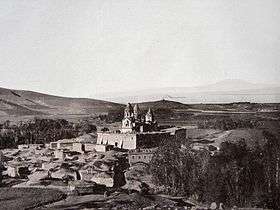

Alp Arslan divided the conquered eastern portions of the Byzantine empire among his Turcoman generals, with each ruled as a hereditary beylik, under overall sovereignty of the Great Seljuq Empire. Alp Arslan gave the region around Lake Van to his commander Sökmen el Kutbî (literally Sökmen the Slave), who set up his capital at Ahlat on the western side of the lake. The dynasty of Ahlatshahs (also known as Sökmenler) ruled this area from 1085 to 1192.
The Ahlatshahs were succeeded by the Ayyubid dynasty.
Architecture
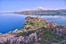
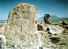
Near the Van Castle and the southern shore, on Akdamar Island lies the 10th century Church of the Holy Cross (Armenian: Սուրբ Խաչ, Surb Khach), which served as a royal church to the Armenian Vaspurakan kingdom. The ruins of Armenian monasteries also exist on the other three islands of Lake Van: Lim, Arter, and Ktuts. The area around Lake Van was also the home to a large number Armenian monasteries, among the most prominent of these being the 10th century Narekavank and the 11th century Varagavank, the former now destroyed.
The Ahlatshahs left a large number of historic tombstones in and around the town of Ahlat. Local administrators are currently trying to have the tombstones included in UNESCO's World Heritage List, where they are currently listed tentatively.[25][26]
Transportation
The railway connecting Turkey and Iran was built in the 1970s, sponsored by CENTO. It uses a train ferry across Lake Van between the cities Tatvan and Van, rather than building railway tracks around the rugged shoreline. Transfer from train to ship and back again limits the total carrying capacity. In May 2008 talks started between Turkey and Iran to replace the ferry route with a new double track electrified railway.[27]
In December 2015 the new generation of train ferries operated by the Turkish State Railways, the largest of their kind in Turkey, entered service in Lake Van.[24]
Ferit Melen Airport in Van is located close to the shore of Lake Van. Turkish Airlines, AnadoluJet, Pegasus Airlines and SunExpress are the airline companies in Turkey which have regular flights to this airport.
Sports
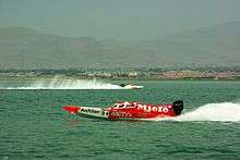
Lake Van occasionally hosts several water sports, sailing and inshore powerboat racing events, such as the UIM World Offshore 225 Championship's IOC Van Grand Prix, and the Van Lake Festival.
Islands
See also
References
- 1 2 3 Coskun & Musaoğlu 2004.
- 1 2 3 4 5 Degens et al. 1984.
- ↑ "Lake Van" 1998.
- 1 2 Wong & Degens 1978.
- ↑ Tomonaga, Brennwald & Kipfer 2011.
- ↑ Sarı 2008.
- 1 2 3 Toker et al. 2017, p. 166.
- 1 2 Toker et al. 2017, p. 167.
- ↑ Kempe & Degens 1978.
- ↑ Oswald 1906, pp. 102–103.
- ↑ Landmann et al. 1996.
- ↑ University of Bonn 2007.
- ↑ Матвеев: Турция [что значительно ниже установленной позже корректной цифры в 161,2 метра] (in Russian)
- ↑ Warren 2006.
- ↑ Danulat & Kempe 2008.
- ↑ Sarı 2006.
- ↑ Selçuk 1992
- ↑ Kempe et al.
- ↑ Cottrell 1960, p. 488.
- ↑ Gibbens 2017.
- ↑ Ancient castle studied... 2017.
- ↑ Ebeling & Meissner 1997, p. 2.
- 1 2 Hewsen 1997, p. 9.
- 1 2 Mina 2015.
- ↑ Oktay 2007.
- ↑ UNESCO n.d.
- ↑ APA 2007.
Sources
| Wikimedia Commons has media related to Lake Van. |
- "Ancient castle studied in Lake Van", Hürriyet Daily News, retrieved 27 February 2018
- APA (27 July 2007), "Turkey, Iran agree on joint railway", Yeni Şafak
- Coskun, M.; Musaoğlu, N. (2004), "Investigation of Rainfall-Runoff Modelling of the Van Lake Catchment by Using Remote Sensing and GIS Integration" (PDF), Proceedings of the 20th Congress of the International Society for Photogrammetry and Remote Sensing (PDF)
|format=requires|url=(help) - Cottrell, Leonard (1960), The Concise Encyclopædia of Archaeology
- Danulat, Eva; Kempe, Stephan (February 1992), "Nitrogenous waste excretion and accumulation of urea and ammonia in Chalcalburnus tarichi (Cyprinidae), endemic to the extremely alkaline Lake Van (Eastern Turkey)", Fish Physiology and Biochemistry, 9 (5–6): 377–386, doi:10.1007/BF02274218
- Degens, E.T.; Wong, H.K.; Kempe, S.; Kurtman, F. (June 1984), "A geological study of Lake Van, eastern Turkey", International Journal of Earth Sciences, Springer, 73 (2): 701–734, doi:10.1007/BF01824978
- Ebeling, Erich; Meissner, Bruno (1997), Reallexikon der Assyriologie und vorderasiatischen Archäologie [Lexicon of Assyriology and Near Eastern Archeology] (in German), Berlin: de Gruyter, p. 2, ISBN 3110148099
- Gibbens, Sarah (15 November 2017), Ancient Ruins Discovered Under Lake in Turkey, National Geographic, retrieved 27 February 2018
- Hewsen, Robert H. (September 1997), "The Geography of Armenia", in Hovannisian, Richard G., The Armenian People From Ancient to Modern Times, Volume I – The Dynastic Periods: From Antiquity to the Fourteenth Century, New York: St. Martin's Press, pp. 1–17, ISBN 0-312-10169-4
- Kempe, S.; Degens, E.T. (1978), "Lake Van varve record: the past 10,420 years", in Degens, E.T.; Kurtman, F., Geology of Lake Van, Ankara: MTA Press, pp. 56–63
- Kempe, S.; Kazmierczak, J.; Landmann, G.; Konuk, T.; Reimer, A.; Lipp, A. (14 February 1991), "Largest known microbialites discovered in Lake Van, Turkey", Nature, 349 (6310): 605–608, doi:10.1038/349605a0
- "Lake Van", The New Encyclopædia Britannica, 1998
- Landmann, Günter; Reimera, Andreas; Lemcke, Gerry; Kempe, Stephan (June 1996), "Dating Late Glacial abrupt climate changes in the 14,570 yr long continuous varve record of Lake Van, Turkey", Palaeogeography, Palaeoclimatology, Palaeoecology, Elsevier Science B.V., 122 (1–4): 107–118, doi:10.1016/0031-0182(95)00101-8
- Mina, Muhammed (19 December 2015), Türkiye'nin en büyük feribotu Van Gölü'nde deneme seferine çıktı [Turkey's Largest Ferry Begins Trial Voyage on Lake Van] (in Turkish), Hürriyet, retrieved 4 June 2016
- Oktay, Yüksel (8 May 2007), On the Roads of Anatolia — Van, Los Angeles Chronicle, archived from the original on 28 September 2007
- Oswald, Felix (1906), A Treatise on the Geology of Armenia
- Sarı, Mustafa (2006), Inci Kefalı Summary, Doğa Gözcüleri Derneği, archived from the original on 11 January 2008
- Sarı, Mustafa (2008), "Threatened fishes of the world: Chalcalburnus tarichi (Pallas 1811) (Cyprinidae) living in the highly alkaline Lake Van, Turkey", Environmental Biology of Fishes, Springer Netherlands, 81 (1): 21–23, doi:10.1007/s10641-006-9154-9
- Toker, Mustafa; Sengör, Ali Mehmet Celal; Demirel Schluter, Filiz; Demirbağ, Emin; Çukur, Deniz; İmren, Caner; Niessen, Frank (May 2017), "The structural elements and tectonics of the Lake Van basin (Eastern Anatolia) from multi-channel seismic reflection profiles", Journal of African Earth Sciences, 129: 165–178, doi:10.1016/j.jafrearsci.2017.01.002
- Tomonaga, Yama; Brennwald, Matthias S.; Kipfer, Rolf (2011), "Spatial distribution and flux of terrigenic He dissolved in the sediment pore water of Lake Van (Turkey)", Geochimica et Cosmochimica Acta, 75 (10): 2848–2864, doi:10.1016/j.gca.2011.02.038
- UNESCO, Tentative World Heritage Sites
- University of Bonn (15 March 2007), Turkey's Lake Van Provides Precise Insights Into Eurasia's Climate History, Science Daily
- Warren, J.K. (2006), Evaporites: Sediments, Resources and Hydrocarbons, Springer, ISBN 3-540-26011-0
- Wong, H.K.; Degens, E.T. (1978), "The bathymetry of Lake Van, eastern Turkey", Geology of Lake Van (169), Ankara: General Directorate of Mineral Research and Exploration, pp. 6–10
| Islands | | |
|---|---|---|
| Cities | ||
| Neighboring lakes and dams |
| |
| Authority control |
|---|