Yaviza
| Yaviza | |
|---|---|
| Corregimiento and town | |
 Yaviza | |
| Coordinates: 8°9′18″N 77°41′31″W / 8.15500°N 77.69194°WCoordinates: 8°9′18″N 77°41′31″W / 8.15500°N 77.69194°W | |
| Country |
|
| Province | Darién |
| District | Pinogana |
| Area[1] | |
| • Land | 397.1 km2 (153.3 sq mi) |
| Population (2010)[1] | |
| • Total | 4,441 |
| • Density | 11.2/km2 (29/sq mi) |
| Population density calculated based on land area. | |
| Time zone | UTC−5 (EST) |
Yaviza is a town and corregimiento in Pinogana District, Darién Province, Panama with a population of 4,441 as of 2010.[1] The town marks the southeastern end of the northern half of the Pan-American Highway, at the north end of the Darién Gap. Its population as of 1990 was 8,452; its population as of 2000 was 3,117.[1]
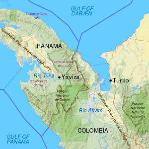
Map of the Darién Gap and the break in the Pan-American Highway between Yaviza, Panama and Turbo, Colombia
References
- 1 2 3 4 "Cuadro 11 (Superficie, población y densidad de población en la República...)" [Table 11 (Area, population, and population density in the Republic...)] (.xls). In "Resultados Finales Básicos" [Basic Final Results] (in Spanish). National Institute of Statistics and Census of Panama. Retrieved May 26, 2015.
This article is issued from
Wikipedia.
The text is licensed under Creative Commons - Attribution - Sharealike.
Additional terms may apply for the media files.