Shinchi, Fukushima
| Shinchi 新地町 | |||
|---|---|---|---|
| Town | |||
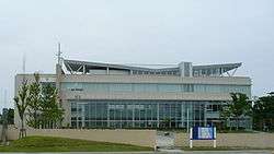 Shinchi Town Hall | |||
| |||
|
Location of Shinchi in Fukushima Prefecture | |||
 Shinchi | |||
| Coordinates: 37°52′34.7″N 140°55′10.6″E / 37.876306°N 140.919611°ECoordinates: 37°52′34.7″N 140°55′10.6″E / 37.876306°N 140.919611°E | |||
| Country | Japan | ||
| Region | Tōhoku | ||
| Prefecture | Fukushima Prefecture | ||
| District | Sōma | ||
| Area | |||
| • Total | 46.53 km2 (17.97 sq mi) | ||
| Population (October 2017) | |||
| • Total | 8,278 | ||
| • Density | 177.9/km2 (461/sq mi) | ||
| Time zone | UTC+9 (Japan Standard Time) | ||
| City symbols | |||
| • Tree | Pine | ||
| • Flower | Sakura | ||
| • Bird | Green pheasant | ||
| • Fish | Pleuronectidae | ||
| Phone number | 0244-62-2111 | ||
| Address | Yachikoya, Shinchi-machi, Sōma-gun, Fukushima-ken 979-2792 | ||
| Website | http://www.shinchi-town.jp/ | ||
Shinchi (新地町 Shinchi-machi) is a town located in Fukushima Prefecture, Japan. As of 1 October 2017, the town has an estimated population of 8,278, and a population density of 178 inhabitants per square kilometre (460/sq mi) in 2832 households.[1] The total area is 56.53 square kilometres (21.83 sq mi).[2]
Geography
Shinchi is located in the far northeastern corner of Fukushima Prefecture, in the Tōhoku region of northern Japan, bordering on Miyagi Prefecture to the north and the Pacific Ocean to the east.
Surrounding municipalities
Climate
Shinchi has a humid climate (Köppen climate classification Cfa). The average annual temperature in Shinchi is 12.5 °C (54.5 °F). The average annual rainfall is 1,259 mm (49.6 in) with September as the wettest month. The temperatures are highest on average in August, at around 24.7 °C (76.5 °F), and lowest in January, at around 1.6 °C (34.9 °F).[3]
Demographics
Per Japanese census data,[4] the population of Shinchi was relatively constant over the past 40 years.
| Census Year | Population |
|---|---|
| 1970 | 8,646 |
| 1980 | 8,704 |
| 1990 | 8,904 |
| 2000 | 9,017 |
| 2010 | 8,224 |
History
The area of present-day Shinchi was part of Mutsu Province, and Kofun period remains have been found in the area. During the Nara period, it was part of ancient Futaba District in Iwaki Province. During the Edo period, it was part of Uda District, which was divided into 51 villages, nine of which (including the coast) was part of the holdings of Sendai Domain, and the remaining 42 of which were ruled by Sōma Domain, ruled by the Sōma clan under the Tokugawa shogunate until the Meiji restoration. On April 1, 1889, the modern village of Shinchi was created within Uda District, Fukushima. Uda District became Sōma District in 1896. On April 20, 1954 Shinchi annexed the neighboring villages of Fukuda and Komagamine. Shinchi was elevated to town status on August 1, 1971.
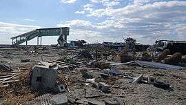
2011 earthquake and tsunami
The eastern, coastal portion of Shinchi was inundated by tsunami flood waters following the magnitude 9.0 2011 Tōhoku earthquake and tsunami off its coastline on March 11, 2011. The tsunami destroyed 577 houses, or approximately half the homes in the town, and the final death toll was 116 residents.
Education
Shinchi has three public elementary schools and one public junior high school operated by the town government, and one public high school operated by the Fukushima Prefectural Board of Education.
Transportation
Railway
Highway
- Jōban Expressway - Shinchi Interchange
- Japan National Route 6
- Japan National Route 113
References
- ↑ Shinchi town official home page (in Japanese)
- ↑ "Home" (in Japanese). Shinchi Town. Retrieved 6 February 2015.
- ↑ Shinchi climate data
- ↑ Shinchi population statistics
![]()
External links
![]()
- Official Website (in Japanese)