Knox Township, Jefferson County, Ohio
| Knox Township, Jefferson County, Ohio | |
|---|---|
| Township | |
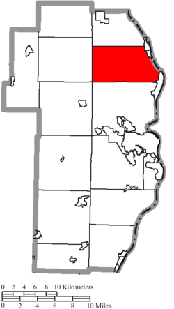 Location of Knox Township in Jefferson County | |
| Coordinates: 40°28′51″N 80°38′15″W / 40.48083°N 80.63750°WCoordinates: 40°28′51″N 80°38′15″W / 40.48083°N 80.63750°W | |
| Country | United States |
| State | Ohio |
| County | Jefferson |
| Area | |
| • Total | 29.7 sq mi (76.8 km2) |
| • Land | 29.4 sq mi (76.0 km2) |
| • Water | 0.3 sq mi (0.8 km2) |
| Elevation[1] | 955 ft (291 m) |
| Population (2010) | |
| • Total | 4,670 |
| • Density | 157.2/sq mi (60.8/km2) |
| Time zone | UTC-5 (Eastern (EST)) |
| • Summer (DST) | UTC-4 (EDT) |
| FIPS code | 39-40866[2] |
| GNIS feature ID | 1086379[1] |

Knox Township is one of the fourteen townships of Jefferson County, Ohio, United States. The 2010 census found 4,670 people in the township, 2,048 of whom lived in the unincorporated portions of the township.[3]
Geography
Located in the northeastern part of the county along the Ohio River, it borders the following townships:
- Saline Township - north
- Island Creek Township - south
- Salem Township - southwest corner
- Ross Township - west
Hancock County, West Virginia lies across the Ohio River to the east.
Three incorporated municipalities are located along the Ohio River in eastern Knox Township:
- Part of the village of Stratton, upstream
- The village of Empire, in the middle
- Part of the city of Toronto, downstream
As well, the unincorporated community of New Somerset lies in the northern part of the township.
Name and history
Knox Township is named for Henry Knox, first U.S. Secretary of War.[4]
It is one of five Knox Townships statewide.[5]
Government
The township is governed by a three-member board of trustees, who are elected in November of odd-numbered years to a four-year term beginning on the following January 1. Two are elected in the year after the presidential election and one is elected in the year before it. There is also an elected township fiscal officer,[6] who serves a four-year term beginning on April 1 of the year after the election, which is held in November of the year before the presidential election. Vacancies in the fiscal officership or on the board of trustees are filled by the remaining trustees.
References
- 1 2 "US Board on Geographic Names". United States Geological Survey. 2007-10-25. Retrieved 2008-01-31.
- ↑ "American FactFinder". United States Census Bureau. Retrieved 2008-01-31.
- ↑ "American FactFinder". United States Census Bureau. Retrieved 26 July 2018.
- ↑ Doyle, Joseph Beatty (1910). 20th Century History of Steubenville and Jefferson County, Ohio and Representative Citizens. Richmond-Arnold Publishing Company. p. 454.
- ↑ "Detailed map of Ohio" (PDF). United States Census Bureau. 2000. Retrieved 2007-02-16.
- ↑ §503.24, §505.01, and §507.01 of the Ohio Revised Code. Accessed 4/30/2009.
External links
Municipalities and communities of Jefferson County, Ohio, United States | ||
|---|---|---|
| Cities | 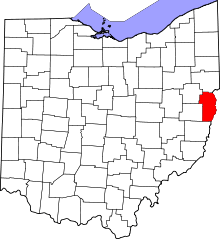 | |
| Villages | ||
| Townships | ||
| CDPs | ||
| Other unincorporated communities |
| |
| Ghost town | ||
| Footnotes | ‡This populated place also has portions in an adjacent county or counties | |
| Counties |  Map of the Pittsburgh Tri-State with green counties in the metropolitan area and yellow counties in the combined area. | |
|---|---|---|
| Major cities | ||
| Cities and towns 15k-50k (in 2010) | ||
| Airports | ||
| Topics | ||
| ||