Kaileuna
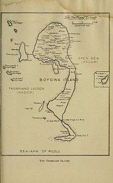
Kaileuna is an island in the Trobriand Islands group of Papua New Guinea. With an area of 45.53 km², it is the second-largest island in the group, after Kiriwina.[1]
As of the census of the population of 2000, there were 1,908 people living on the island, in five villages:
- Kaduwaga (645)
- Kaisiga (409)
- Tawema (352)
- Koma (282)
- Giva (220)
A sixth village, Lebola, was uninhabited. Older maps still show a seventh village, Bulakwa, in the very south. The largest village, Kaduwaga, is on the north-west coast of the island.
Between Bulakwa and Kaisiga villages, two villages Musa and Kapisila have been established. Kapisila is part of Bulakwa village and Musa village belongs to Kaisiga village. However, all the villages in the South of Kaileuna Island are referred to as 'Kaisiga'.
References
Literature
- Gunter Senft: Landscape terms and place names in the Trobriand Islands – the Kaile’una subset. In: Language Sciences 30 (2008) 340–361 (online)
Coordinates: 8°31′31″S 150°56′58″E / 8.52528°S 150.94944°E