Kızılırmak, Çankırı
| Kızılırmak | |
|---|---|
| Town | |
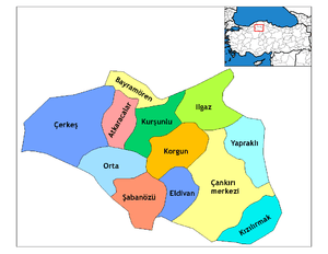 Location of Kızılırmak, Çankırı within Turkey. | |
 Kızılırmak Location of Kızılırmak, Çankırı within Turkey. | |
| Coordinates: 40°20′N 33°59′E / 40.333°N 33.983°ECoordinates: 40°20′N 33°59′E / 40.333°N 33.983°E | |
| Country |
|
| Province | Çankırı |
| Government | |
| • Mayor | Bayar Soysal (AKP) |
| Area[1] | |
| • District | 434.28 km2 (167.68 sq mi) |
| Population (2012)[2] | |
| • Urban | 2,127 |
| • District | 8,010 |
| • District density | 18/km2 (48/sq mi) |
| Time zone | UTC+2 (EET) |
| • Summer (DST) | UTC+3 (EEST) |
| Postal code | 18xxx |
| Area code(s) | 0 |
| Licence plate | 18 |
| Website | www.cankiri.gov.tr |
Kızılırmak is a town and district of Çankırı Province in the Central Anatolia region of Turkey. It takes its name from the river Kızılırmak.
References
- ↑ "Area of regions (including lakes), km²". Regional Statistics Database. Turkish Statistical Institute. 2002. Retrieved 2013-03-05.
- ↑ "Population of province/district centers and towns/villages by districts - 2012". Address Based Population Registration System (ABPRS) Database. Turkish Statistical Institute. Retrieved 2013-02-27.
External links
- District municipality's official website (in Turkish)
This article is issued from
Wikipedia.
The text is licensed under Creative Commons - Attribution - Sharealike.
Additional terms may apply for the media files.