Jingzhou
| Jingzhou 荆州市 | |
|---|---|
| Prefecture-level city | |
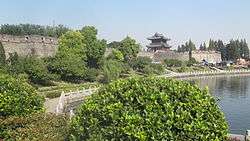 Jingzhou old city wall. | |
.png) Location of Jingzhou City jurisdiction in Hubei | |
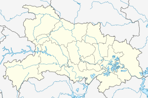 Jingzhou Location in Hubei | |
| Coordinates: 30°20′N 112°13′E / 30.333°N 112.217°E | |
| Country | People's Republic of China |
| Province | Hubei |
| Area[1] | |
| • Prefecture-level city | 14,068.68 km2 (5,431.95 sq mi) |
| • Urban | 1,562.2 km2 (603.2 sq mi) |
| • Metro | 1,562.2 km2 (603.2 sq mi) |
| Population (2010)[1][2] | |
| • Prefecture-level city | 5,691,707 |
| • Density | 400/km2 (1,000/sq mi) |
| • Urban | 1,154,086 |
| • Urban density | 740/km2 (1,900/sq mi) |
| • Metro | 1,154,086 |
| • Metro density | 740/km2 (1,900/sq mi) |
| Time zone | UTC+8 (China Standard) |
| ISO 3166 code | CN-HB-10 |
| Licence plate prefixes | 鄂D |
| Website |
jingzhou |
| Jingzhou | |||||||
 "Jingzhou", as written in Simplified Chinese | |||||||
| Simplified Chinese | 荆州 | ||||||
|---|---|---|---|---|---|---|---|
| Traditional Chinese | 荊州 | ||||||
| Postal | Kingchow | ||||||
| |||||||
Jingzhou (Chinese: 荆州) is a prefecture-level city in southern Hubei, China, located on the banks of the Yangtze River. Based on the 2010 census, its total population was 5,691,707,[1] 1,154,086 of whom resided in the built-up (or metro) area comprising the two urban districts.
Jingzhou's central urban area has grown out of a city historically known as Shashi; this name is preserved in the name of Shashi District, which includes the city's historical center, as well as in the names of a number of local facilities, such as Shashi Airport and a railway freight station.
Geography and climate
Jingzhou occupies an area of 14,067 square kilometres (5,431 sq mi)[1] with a topography rising from east to west. It is covered by a dense network of waterways, as well as lakes, and is located in the middle reaches of the Yangtze River on the Jianghan Plain. Downstream to its east lies Wuhan, the provincial capital and to the west the city of Yichang, the Three Gorges, and finally Chongqing Municipality. Jingmen City, also in Hubei, lies to the north; to its south are Yueyang and Changde, both in Hunan Province.
Jingzhou has a humid subtropical climate (Köppen Cfa), with hot, humid summers, and damp, chilly, but drier winters. Monthly daily average temperatures range from 4.1 °C (39.4 °F) in January to 28.0 °C (82.4 °F) in July. The area receives 1,800 to 2,000 hours of sunshine per year and has a frost-free period of 242−263 days annually.[3]
| Climate data for Jingzhou(1971−2000) | |||||||||||||
|---|---|---|---|---|---|---|---|---|---|---|---|---|---|
| Month | Jan | Feb | Mar | Apr | May | Jun | Jul | Aug | Sep | Oct | Nov | Dec | Year |
| Record high °C (°F) | 21.9 (71.4) |
25.0 (77) |
28.0 (82.4) |
33.1 (91.6) |
35.4 (95.7) |
37.2 (99) |
37.9 (100.2) |
38.6 (101.5) |
36.8 (98.2) |
33.2 (91.8) |
29.3 (84.7) |
21.1 (70) |
38.6 (101.5) |
| Average high °C (°F) | 8.1 (46.6) |
10.2 (50.4) |
14.2 (57.6) |
21.1 (70) |
26.1 (79) |
29.3 (84.7) |
32.0 (89.6) |
32.0 (89.6) |
27.5 (81.5) |
22.4 (72.3) |
16.3 (61.3) |
10.8 (51.4) |
20.8 (69.5) |
| Daily mean °C (°F) | 4.1 (39.4) |
6.0 (42.8) |
10.1 (50.2) |
16.7 (62.1) |
21.6 (70.9) |
25.2 (77.4) |
28.0 (82.4) |
27.7 (81.9) |
23.0 (73.4) |
17.6 (63.7) |
11.7 (53.1) |
6.4 (43.5) |
16.5 (61.7) |
| Average low °C (°F) | 0.9 (33.6) |
2.8 (37) |
6.6 (43.9) |
12.9 (55.2) |
17.9 (64.2) |
21.8 (71.2) |
24.7 (76.5) |
24.4 (75.9) |
19.6 (67.3) |
14.0 (57.2) |
8.0 (46.4) |
2.9 (37.2) |
13.0 (55.5) |
| Record low °C (°F) | −14.9 (5.2) |
−9.2 (15.4) |
−1 (30) |
−0.1 (31.8) |
9.8 (49.6) |
13.0 (55.4) |
18.1 (64.6) |
17.5 (63.5) |
10.6 (51.1) |
1.7 (35.1) |
−3 (27) |
−6.3 (20.7) |
−14.9 (5.2) |
| Average precipitation mm (inches) | 29.6 (1.165) |
44.8 (1.764) |
75.4 (2.969) |
107.6 (4.236) |
140.8 (5.543) |
159.9 (6.295) |
151.2 (5.953) |
119.9 (4.72) |
89.3 (3.516) |
86.8 (3.417) |
55.2 (2.173) |
23.4 (0.921) |
1,083.9 (42.672) |
| Average precipitation days (≥ 0.1 mm) | 8.2 | 9.1 | 12.9 | 12.8 | 13.3 | 13.0 | 10.5 | 9.4 | 9.2 | 10.6 | 8.5 | 6.8 | 124.3 |
| Source: Weather China[3] | |||||||||||||
Demographics
According to the 2010 Census, the prefecture-level city of Jingzhou has 5,691,707 inhabitants[1] and a population density of 405 inhabitants per km².[4]
Administration
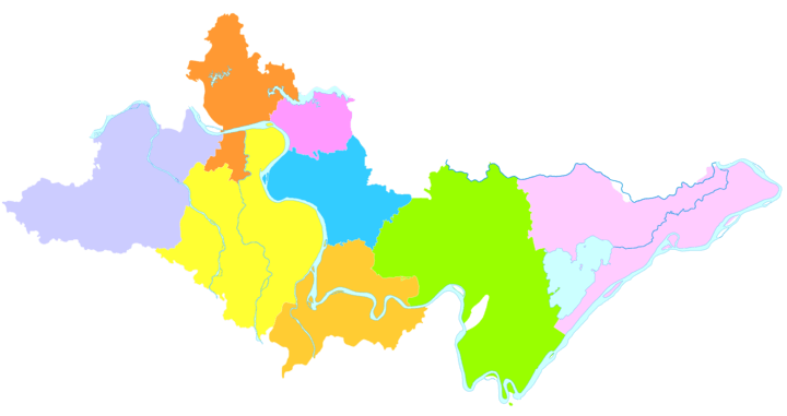
The prefecture-level city of Jingzhou has jurisdiction over two districts, three county-level cities, three counties and one economic and technological development zone.[1][5][6] The information here presented uses the metric system and data from the 2010 Census.
| Map | |||||
|---|---|---|---|---|---|
| Name | Simplified Chinese | Hanyu Pinyin | Area (K㎡) |
Population (2010)[1] |
Density (/K㎡) |
| Jingzhou District | 荆州区 | Jīngzhōu Qū | 1,046 | 553,756 | 529 |
| Shashi District | 沙市区 | Shāshì Qū | 469 | 498,526 | 1,063 |
| Jingzhou Economic and Technological Development Zone[6][7] | 荆州经济技术开发区 | Jīngzhōu Jīngjì Jìshù Kāifāqū | 101,804 | ||
| Songzi City | 松滋市 | Sōngzī Shì | 2,235 | 765,911 | 343 |
| Shishou City | 石首市 | Shíshǒu Shì | 1,427 | 577,022 | 404 |
| Honghu City | 洪湖市 | Hónghú Shì | 2,519 | 819,446 | 325 |
| Jiangling County | 江陵县 | Jiānglíng Xiàn | 1,032 | 331,344 | 321 |
| Gong'an County | 公安县 | Gōng'ān Xiàn | 2,258 | 881,128 | 390 |
| Jianli County | 监利县 | Jiànlì Xiàn (Jiānlì Xiàn) | 3,118 | 1,162,770 | 373 |
History

Jingzhou has been a transportation hub and commodity distribution center for 6,000 years.
The ancient city of Jingzhou forms what is now the main urban area of Jiangling County, which is one of the counties within Jingzhou City. Situated in the middle reaches of the Yangtze River, this has been a strategic location of military importance since ancient times.
Ying, within the borders of present-day Jingzhou, was the capital of 20 kings over 411 years of the State of Chu during the Spring and Autumn and Warring States periods of the Zhou Dynasty (1046 BCE - 256 BCE).
The city is said to have been built with earth by Guan Yu in the Three Kingdoms period. During the Southern and Northern Dynasties period, it was the capital of the Western Liang. In the Five Dynasties and Ten Kingdoms period, it was the capital of Jingnan (the Nanping State).
Sights
Numerous sites have been preserved from the Chu State period, including the ruins of five Chu cities, 73 sites featuring Chu Culture and more than 800 ancient tombs, including those of 18 Chu kings.
There are also historical sites dating to the Three Kingdoms period, such as the Wulin Battlefield (where the Battle of Red Cliffs took place) and the Huarong Path.

The city walls were rebuilt in 1646 and measure 9 metres (30 ft) high and 10 metres (33 ft) thick. The perimeter of the wall extends for 10.17 kilometres (6.32 mi). The city walls, city gates, watchtowers, and battlements have all been well maintained. Many of the towers on top of the majestic city gates have been damaged or rebuilt, leaving only the Chaozong Tower which was rebuilt in 1838 on the Gongji Gate.
The Jingzhou Museum has on display a well-preserved 2,000-year-old male corpse. Also on display are silk and lacquerware from the Warring States period.
Transportation
- China National Highway 207
- China National Highway 318
- Jingzhou Railway Station on the Wuhan-Yichang Railway, with frequent passenger service to Yichang and Wuhan
- Jingmen-Shashi Railway (freight only)
- Shashi Airport in Shashi district
Sister Cities


See also
| Wikimedia Commons has media related to Jingzhou. |
| Wikisource has the text of the 1911 Encyclopædia Britannica article Shasi. |
References
- 1 2 3 4 5 6 7 荆州市历史沿革 [Jingzhou City Historical Development]. 行政区划网站 www.xzqh.org (in Simplified Chinese). 行政区划网站/区划地名网站 (Administrative Divisions Web/District Geographic Names Web). 6 August 2014. Retrieved 11 June 2018.
全市国土面积14067平方千米{...}2010年第六次人口普查,荆州市常住总人口5691707人,其中:沙市区600330人,荆州区553756人,公安县881128人,监利县1162770人,江陵县331344人,石首市577022人,洪湖市819446人,松滋市765911人。
- ↑ http://www.citypopulation.de/php/china-hubei-admin.php
- 1 2 荆州城市介绍 (in Chinese). Weather China. Retrieved 2012-02-04.
- ↑ (in Chinese) Compilation by LianXin website. Data from the Sixth National Population Census of the People's Republic of China Archived 2011-06-22 at the Wayback Machine.
- ↑ 2016年统计用区划代码和城乡划分代码:荆州市 [2016 Statistical Area Numbers and Rural-Urban Area Numbers: Jingzhou City]. National Bureau of Statistics of the People's Republic of China. 2016. Retrieved 11 June 2018.
统计用区划代码 名称 421001000000 市辖区 421002000000 沙市区 421003000000 荆州区 421022000000 公安县 421023000000 监利县 421024000000 江陵县 421081000000 石首市 421083000000 洪湖市 421087000000 松滋市
- 1 2 城市概况 [City Description]. 荆州市人民政府门户网站 (in Simplified Chinese). 荆州市政府办公室 荆州市政府政务公开和电子信息办公室 荆州新闻网 荆州日报 荆州电视台 荆州人民广播电台. Retrieved 11 June 2018.
荆州区 沙市区 江陵县 松滋市 公安县 石首市 监利县 洪湖市 荆州经济技术开发区
- ↑ http://www.xzqh.org/html/show/hb/37311.html