Dianjun District
| Dianjun 点军区 | |
|---|---|
| District | |
 | |
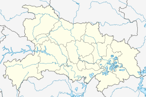 Dianjun Location in Hubei | |
| Coordinates: 30°41′15″N 111°15′29″E / 30.68750°N 111.25806°ECoordinates: 30°41′15″N 111°15′29″E / 30.68750°N 111.25806°E | |
| Country | People's Republic of China |
| Province | Hubei |
| Prefecture-level city | Yichang |
| Area | |
| • Total | 546 km2 (211 sq mi) |
| Population (2004) | |
| • Total | 105,175 |
| • Density | 190/km2 (500/sq mi) |
| Time zone | UTC+8 (China Standard) |
| Postal code | 443000 |
Dianjun District (simplified Chinese: 点军区; traditional Chinese: 點軍區; pinyin: Diǎnjūn Qū) is a district of the city of Yichang, Hubei, People's Republic of China. It contains 3 townships with 23 villages.[1] In 2004 it had 105,175 residents.[2]
The district is located on the right (southwestern) bank of the Yangtze, opposite the Yichang City center (which, administratively, forms Xiling District).
Transportation
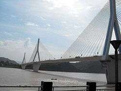
Dianjun District is connected to Yichang's Xiling District by the Yiling Bridge (which carries Provincial Highway 323) and a railway bridge (which carries the Yichang-Wanzhou Railway).
Dianjun is served by the freight-only Yichang South Railway Station on the Yichang-Wanzhou Railway.
References
- ↑ Asian Development Bank
- ↑ www.xzqh.org Archived 2009-08-16 at the Wayback Machine. (in Chinese)
This article is issued from
Wikipedia.
The text is licensed under Creative Commons - Attribution - Sharealike.
Additional terms may apply for the media files.