Jambi City
| Jambi City Kota Jambi | ||
|---|---|---|
| City | ||
| Other transcription(s) | ||
| • Jawi | بندارايا جمبي | |
 Jambi city panoramic in evening | ||
| ||
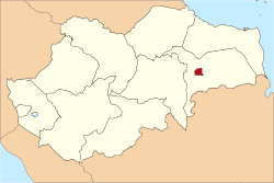 Location within Jambi Province | ||
| Coordinates: 1°35′24″S 103°36′36″E / 1.59000°S 103.61000°ECoordinates: 1°35′24″S 103°36′36″E / 1.59000°S 103.61000°E | ||
| Country |
| |
| Province |
| |
| Government | ||
| • Mayor | S.Y. Fasha | |
| • Vice Mayor | Abdullah Sani | |
| Area | ||
| • Total | 205.38 km2 (79.30 sq mi) | |
| Elevation | 16 m (52 ft) | |
| Population (2010) | ||
| • Total | 531,857 | |
| • Density | 2,589.6/km2 (6,707/sq mi) | |
| Time zone | UTC+7 (Indonesia Western Time) | |
| Area code | (+62) 741 | |
| Website | www.kotajambi.go.id | |


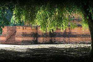
Jambi City (Indonesian: Kota Jambi, or Malay: Bandaraya Jambi) is a city in Indonesia, capital of Jambi province, on the island of Sumatra. The city is a busy port on the Batang Hari River and an oil- and rubber-producing centre. The city is located 26 km (16 mi) from the ruins of Muaro Jambi, an important city in the ancient Srivijaya kingdom.
Nearby towns and villages include Mendalo (5.1 nmi (9.4 km; 5.9 mi)), Kinati (4.1 nmi (7.6 km; 4.7 mi)), Padang (4.5 nmi (8.3 km; 5.2 mi)), Tanjungjohor (3.2 nmi (5.9 km; 3.7 mi)), Paalmerah (2.8 nmi (5.2 km; 3.2 mi)), and Muarakumpe (3.6 nmi (6.7 km; 4.1 mi)). Jambi is served by the Sultan Thaha Airport.
History
Jambi City was denoted as the administrative capital of the Jambi autonomic area by the Governor of Sumatra on 17 May 1946. In 1956, Jambi City was given its city status, and eventually became the capital of Jambi province on 6 January 1957.
Geography
The total land area of Jambi city is 205.38 km2 (79 sq mi). Jambi City is located at the south-western portion of the Sumatran Basin, a low-lying area in Eastern Sumatra with an altitude of 0 to 60m above sea level. A segment of the Batanghari River, the longest river in Sumatra at 1,700 km (1,056 mi), flows through Jambi City.
Jambi City has a tropical climate with a minimum temperature of 22 to 23 °C (72 to 73 °F) and a maximum termperature of 30 to 32 °C (86 to 90 °F). The level of humidity ranges from 82 to 28%. Annual rainfall of Jambi City is 2,296.1 mm (90.4 in), with the rainy season lasting from October to March with 20 rainy days a month. The dry season lasts from April to September with an average of 16 rainy days a month.
Demographics
Jambi City is the most populated city in Jambi Province, with 17% of the province's population living in this city.
Administrative districts
The city of Jambi is subdivided into eight administrative districts (kecamatan), listed below with their populations at the 2010 Census:[1]
- Kota Baru (139,359)
- Jambi Selatan (South Jambi) (124,280)
- Jelutung (60,544)
- Pasar Jambi (12,800)
- Telanaipura (92,366)
- Danau Teluk (11,824)
- Pelayangan (12,861)
- Jambi Timur (East Jambi) (77,823)
Twin towns – sister cities
Jambi City is twinned with:


References
- ↑ Biro Pusat Statistik, Jakarta, 2011.
External links
| Wikivoyage has a travel guide for Jambi. |
- Official site
- Provinsi Jambi
- Sarolangun
- Informasi Jambi
- Kabar Jambi
- Merangin
- Tv Jambi
- Informasi Jambi
- Tentang Jambi
- Tv Online Jambi
- Pariwisata Jambi
- Berita Jambi
- Muaro Jambi
| 2,000,000 and more | |
|---|---|
| 1,000,000-1,999,999 | |
| 400,000-999,999 | |
| 200,000-399,999 | |
| Authority control |
|---|