Jamaica–Van Wyck (IND Archer Avenue Line)
Jamaica–Van Wyck | |||||||||||
|---|---|---|---|---|---|---|---|---|---|---|---|
|
| |||||||||||
 Station platform | |||||||||||
| Station statistics | |||||||||||
| Address |
West side of Van Wyck Expressway between Metropolitan Avenue & 89th Avenue Queens, NY 11418 | ||||||||||
| Borough | Queens | ||||||||||
| Locale | Richmond Hill | ||||||||||
| Coordinates | 40°42′07″N 73°49′00″W / 40.701905°N 73.81656°WCoordinates: 40°42′07″N 73°49′00″W / 40.701905°N 73.81656°W | ||||||||||
| Division | B (IND) | ||||||||||
| Line | IND Archer Avenue Line | ||||||||||
| Services |
E | ||||||||||
| Transit connections |
| ||||||||||
| Structure | Underground | ||||||||||
| Platforms | 1 island platform | ||||||||||
| Tracks | 2 | ||||||||||
| Other information | |||||||||||
| Opened | December 11, 1988 | ||||||||||
| Station code | 280[1] | ||||||||||
| Accessible |
| ||||||||||
| Wireless service |
| ||||||||||
| Traffic | |||||||||||
| Passengers (2017) |
1,555,962[4] | ||||||||||
| Rank | 296 out of 425 | ||||||||||
| Station succession | |||||||||||
| Next east |
Sutphin Boulevard–Archer Avenue–JFK Airport: E | ||||||||||
| Next west |
Briarwood (local): E Kew Gardens–Union Turnpike (express): E | ||||||||||
|
| |||||||||||
| Next |
Sutphin Boulevard–Archer Avenue–JFK Airport: E | ||||||||||
| Next |
Kew Gardens–Union Turnpike: E | ||||||||||
| |||||||||||
| |||||||||||
| |||||||||||


Jamaica–Van Wyck (/væn
History
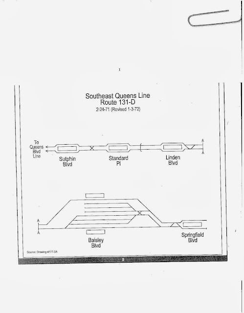
The plans for the Archer Avenue Lines emerged in the 1960s under the city and MTA's Program for Action.[6] It was conceived as an expansion of IND Queens Boulevard Line service to a "Southeast Queens" line along the right-of-way of the Long Island Rail Road Atlantic Branch towards Locust Manor, and as a replacement for the dilapidated eastern portions of the elevated BMT Jamaica Line within the Jamaica business district which business owners and residents sought removal of. Both lines would meet at the double-decked line under Archer Avenue. The two-track spur from the Queens Boulevard Line would use the original Van Wyck Boulevard bellmouths.[7][8][9][6] The IND line was to continue as a two-track line along the LIRR Atlantic Branch. It would have run through Locust Manor and Laurelton stations, with stops at Sutphin Boulevard, Parsons Boulevard (which was called Standard Place in planning documents), Linden Boulevard, Baisley Boulevard, and Springfield Boulevard.[10]
Construction on the Jamaica–Van Wyck station started on October 17, 1979. At this point, the segment of the Archer Avenue Line under the Van Wyck Expressway had been completed.[11] The station opened along with the rest of the Archer Avenue Line on December 11, 1988.[12][13] Because of the 1975 New York City fiscal crisis, the Archer Avenue Line was never fully built to Springfield Boulevard, and was instead truncated to Parsons Boulevard. The shortened version of the line contained three stations, including Jamaica–Van Wyck, and was 2 miles (3.2 km) long.[13]
Station layout
| G | Street Level | Exit/ Entrance |
| B1 | Mezzanine | Fare control, station agents |
| B2 | Inbound[note 1] | ← |
| Island platform, doors will open on the left | ||
| Outbound[note 2] | → | |
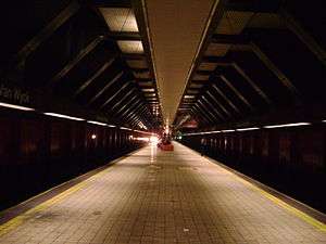
This underground station has two tracks and a 600-foot-long (180 m) island platform.[11] It serves as the replacement for the former Metropolitan Avenue and Queens Boulevard stations of the BMT Jamaica Line. The track walls are mostly orange. The mezzanine is suspended above the Jamaica-bound track via heavy cables linked to the station roof. On the Manhattan-bound side, the station walls contain spaces for windows that can allow natural sunlight in, but they are currently covered over.
North (railroad south) of the station, the tracks lead trains to the IND Queens Boulevard Line, where they either switch to the line's local or express tracks depending on the time of day.[14]
Exits
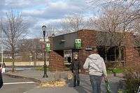
The Jamaica–Van Wyck station has two entrances.[11]

- The other entrance is at Metropolitan Avenue and Jamaica Avenue, and contains one up-only escalator and a street stair. Two escalators and one staircase connect the platform with the mezzanine.[15][16]
Notes
- ↑ This track is actually for trains going compass northbound, but its railroad direction is southbound.
- ↑ This track is actually for trains going compass southbound, but its railroad direction is northbound.
References
- ↑ "Station Developers' Information". Metropolitan Transportation Authority. Retrieved June 13, 2017.
- ↑ "NYC Subway Wireless – Active Stations". Transit Wireless Wifi. Retrieved May 18, 2016.
- ↑ More Subway Stations in Manhattan, Bronx in Line to Get Online, mta.info (March 25, 2015). "The first two phases included stations in Midtown Manhattan and all underground stations in Queens with the exception of the 7 Main St terminal."
- ↑ "Facts and Figures: Annual Subway Ridership 2012–2017". Metropolitan Transportation Authority. July 12, 2018. Retrieved July 12, 2018.
- ↑ Bilefsky, Dan (May 26, 2011). "Stuck on the Van Wyck Expressway? Just Try to Pronounce It". The New York Times. p. A28. Retrieved June 20, 2012.
- 1 2 "Full text of "Metropolitan transportation, a program for action. Report to Nelson A. Rockefeller, Governor of New York."". Internet Archive. November 7, 1967. Retrieved October 1, 2015.
- ↑ Burks, Edward C. (October 24, 1973). "Work Begun on Queens Subway Extension" (PDF). The New York Times. Retrieved September 26, 2015.
- ↑ nycsubway.org—The 1968 MTA "Program for Action"
- ↑ Dembart, Lee (September 9, 1977). "A Sentimental Journey on the BMT..." (PDF). nytimes.com. The New York Times. Retrieved July 2, 2015.
- ↑ "1.bp.blogspot.com/-KeE0zA-o9eQ/UkwMlD5iQgI/AAAAAAAACtM/rJZIo37CvK8/s640/southwest_route.jpg".
- 1 2 3 "New Subway Line" (PDF). Glendale Register. October 25, 1979. p. 11. Retrieved July 25, 2016 – via fultonhistory.com.
- ↑ Anders, Marjorie; Associated Press (December 11, 1988). "Subways get biggest change since 1904" (PDF). Nyack Journal News. p. I1. Retrieved July 25, 2016 – via fultonhistory.com.
- 1 2 Johnson, Kirk (December 9, 1988). "Big Changes For Subways Are to Begin". nytimes.com. The New York Times. Retrieved July 14, 2015.
- ↑ Marrero, Robert (January 1, 2017). "472 Stations, 850 Miles" (PDF). B24 Blog, via Dropbox. Retrieved April 27, 2018.
- 1 2 "MTA Neighborhood Maps: Jamaica" (PDF). mta.info. Metropolitan Transportation Authority. 2015. Retrieved August 1, 2016.
- 1 2 "MTA Neighborhood Maps: Kew Gardens" (PDF). mta.info. Metropolitan Transportation Authority. 2015. Retrieved August 2, 2016.
External links
| Wikimedia Commons has media related to Jamaica – Van Wyck (IND Archer Avenue Line). |
- nycsubway.org – IND Queens Boulevard Line: Jamaica/Van Wyck
- Station Reporter — E Train
- The Subway Nut — Jamaica–Van Wyck Pictures
- Metropolitan Avenue entrance from Google Maps Street View
- 89th Avenue entrance from Google Maps Street View
- Platform from Google Maps Street View
| Archer Ave. Lines |
|
|---|---|
| |