Jackson Township, Callaway County, Missouri
| Jackson Township | |
|---|---|
| Township | |
 | |
| Coordinates: 39°01′01″N 091°52′38″W / 39.01694°N 91.87722°WCoordinates: 39°01′01″N 091°52′38″W / 39.01694°N 91.87722°W | |
| Country | United States |
| State | Missouri |
| County | Callaway |
| Area | |
| • Total | 64.75 sq mi (167.7 km2) |
| • Land | 64.5 sq mi (167.04 km2) |
| • Water | 0.26 sq mi (0.66 km2) 0.39% |
| Elevation[1] | 860 ft (262 m) |
| Population (2010) | |
| • Total | 2,150 |
| • Density | 33/sq mi (13/km2) |
| FIPS code | 29-35612[2] |
| GNIS feature ID | 0766379 |
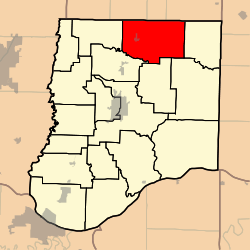
Jackson Township is one of eighteen townships in Callaway County, Missouri, USA. As of the 2010 census, its population was 2,150.[3]
History
Jackson Township (like Shamrock Township) was created sometime between 1876 and 1897, as can be seen from the maps of Callaway County from those years, linked below. As one can see by comparing the maps, Jackson's largest settlement of Auxvasse (and areas west of it) were within the former, more expansive boundaries of Liberty Township -- while the eastern portion of Jackson Township, and Shamrock Township, were part of the now substantially reduced Nine Mile Prairie Township (which then extended northward to the Audrain County border. This is especially significant for historical and genealogical research.
Geography
Jackson Township covers an area of 64.75 square miles (167.7 km2) and contains one incorporated settlement, Auxvasse. It contains four cemeteries: Auxvasse, Grand Prairie, Harrison and Pleasant Grove.
The streams of Bynum Creek, Hunt Branch, Smith Branch and Yates Branch run through this township.
References
- ↑ "US Board on Geographic Names". United States Geological Survey. 2007-10-25. Retrieved 2008-01-31.
- ↑ "American FactFinder". United States Census Bureau. Archived from the original on September 11, 2013. Retrieved 2008-01-31.
- ↑ "Race, Hispanic or Latino, Age, and Housing Occupancy: 2010 Census Redistricting Data (Public Law 94-171) Summary File (QT-PL), Jackson township, Callaway County, Missouri". U.S. Census Bureau, American FactFinder 2. Archived from the original on September 11, 2013. Retrieved October 31, 2011.
External links
- US-Counties.com
- City-Data.com
- (Callaway County 1876 -- see p2 for map of entire county with township boundaries) http://digital.shsmo.org/cdm/ref/collection/plat/id/6022
- (Callaway County 1930 -- see last page for map of entire county with township boundaries) http://cdm16795.contentdm.oclc.org/cdm/ref/collection/moplatbooks/id/656
Municipalities and communities of Callaway County, Missouri, United States | ||
|---|---|---|
| Cities | 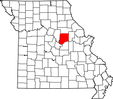 | |
| Village | ||
| Townships | ||
| Unincorporated communities | ||
| Ghost towns | ||
| Footnotes | ‡This populated place also has portions in an adjacent county or counties | |