Auxvasse Township, Callaway County, Missouri
| Auxvasse Township today | |
|---|---|
| Township | |
 | |
| Coordinates: 38°45′37″N 091°45′10″W / 38.76028°N 91.75278°WCoordinates: 38°45′37″N 091°45′10″W / 38.76028°N 91.75278°W | |
| Country | United States |
| State | Missouri |
| County | Callaway |
| Area | |
| • Total | 90.89 sq mi (235.4 km2) |
| • Land | 89.2 sq mi (231.02 km2) |
| • Water | 1.69 sq mi (4.38 km2) 1.86% |
| Elevation[1] | 810 ft (247 m) |
| Population (2010) | |
| • Total | 1,000 |
| • Density | 11/sq mi (4.2/km2) |
| FIPS code | 29-02656[2] |
| GNIS feature ID | 0766370 |
This article is about the township, for the town see: Auxvasse, Missouri
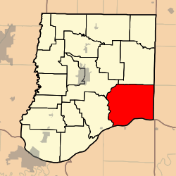
Auxvasse Township is one of eighteen townships in Callaway County, Missouri, USA. As of the 2010 census, its population was 1,000.[3]
History
Defining the boundaries of Auxvasse Township is complicated by several township boundary changes in Callaway County since Missouri statehood in 1821. Auxvasse Township, as closely approximating its current boundaries, was defined in 1826, per this footnoted source.[4] The township derives its name from Auxvasse Creek.[5] However, there was a larger Auxvasse Township created February 12, 1821, only one of two townships (the other being Cote Sans Dessein in its original boundaries) covering the entire county, and which was later reduced in size by the creation of Nine Mile Prairie Township and others. The history of boundary changes in Callaway County townships from statehood to 1884 is summarized, in text and not map format, in the "History of Callaway County", St Louis, 1884, indicated below in the bibliography section. A State Historical Society of Missouri website page on "Place Names of Callaway County" indicates that (per Callaway historian Ovid Bell), "Auxvasse Township was organized February 12, 1821, and named for its principal town and stream", and this would confirm that Auxvasse Township originally, even if briefly, extended from the northern to the southern boundary of Callaway County and the text implies that it may have included the current city of Auxvasse. However, this may have changed within only a few years after Missouri statehood, and may correlate with the 1826 date. Uncovering of actual historical maps from 1821 to 1826 and later should clarify exactly what historical boundaries were.
Geography
Auxvasse Township today (as of 2018) covers an area of 90.89 square miles (235.4 km2) and, although containing no incorporated settlements, does contain the unincorporated settlements of Portland, Readsville, as well as eastern Steedman along its border with St Aubert Township. It contains nine cemeteries: Atterberry, Garrett, Holiness, Lawrence, Liberty, Old Salem, Oliver, Saint Patricks and Washington -- and the streams of Eagle Creek, Little Tavern Creek, Logan Camp Branch, Logan Creek, Means Branch, Meyers Branch, Mollie Dozier Chute, Mud Creek and Tavern Creek.
At its southern border is the Missouri River, most of its western border is with St Aubert Township (incl Mokane), its northwestern border at Fulton Township (incl Fulton), its northern border Nine Mile Prairie Township (incl Williamsburg), and its eastern border is with Montgomery County. Do not confuse today's Auxvasse Township with city of Auxvasse, Missouri in Jackson Township, miles to the north.
References
- ↑ "US Board on Geographic Names". United States Geological Survey. 2007-10-25. Retrieved 2008-01-31.
- ↑ "American FactFinder". United States Census Bureau. Archived from the original on 2013-09-11. Retrieved 2008-01-31.
- ↑ "Race, Hispanic or Latino, Age, and Housing Occupancy: 2010 Census Redistricting Data (Public Law 94-171) Summary File (QT-PL), Auxvasse township, Callaway County, Missouri". U.S. Census Bureau, American FactFinder 2. Archived from the original on September 11, 2013. Retrieved October 31, 2011.
- ↑ Earngey, Bill (1995). Missouri Roadsides: The Traveler's Companion. University of Missouri Press. p. 11.
- ↑ "Callaway County Place Names, 1928–1945 (archived)". The State Historical Society of Missouri. Archived from the original on 24 June 2016. Retrieved 7 September 2016.
- USGS Geographic Names Information System (GNIS)
- Missouri State Library. "History of Callaway County". (St Louis, National Historical Company, 1884).
- Callaway County Place Names 1928-1945: https://web.archive.org/web/20160624071020/http://shsmo.org/manuscripts/ramsay/ramsay_callaway.html
External links
Municipalities and communities of Callaway County, Missouri, United States | ||
|---|---|---|
| Cities | 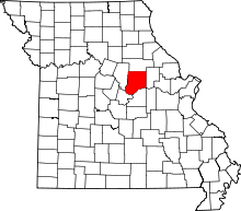 | |
| Village | ||
| Townships | ||
| Unincorporated communities | ||
| Ghost towns | ||
| Footnotes | ‡This populated place also has portions in an adjacent county or counties | |