Cleveland Township, Callaway County, Missouri
| Cleveland Township | |
|---|---|
| Township | |
 | |
| Coordinates: 39°00′02″N 092°05′46″W / 39.00056°N 92.09611°WCoordinates: 39°00′02″N 092°05′46″W / 39.00056°N 92.09611°W | |
| Country | United States |
| State | Missouri |
| County | Callaway |
| Area | |
| • Total | 26.18 sq mi (67.82 km2) |
| • Land | 26.04 sq mi (67.44 km2) |
| • Water | 0.15 sq mi (0.38 km2) 0.56% |
| Elevation[1] | 915 ft (279 m) |
| Population (2010) | |
| • Total | 742 |
| • Density | 28/sq mi (11/km2) |
| FIPS code | 29-14752[2] |
| GNIS feature ID | 0766375 |
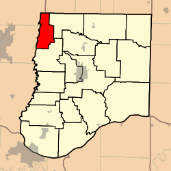
Cleveland Township is one of eighteen townships in Callaway County, Missouri, USA. As of the 2010 census, its population was 742.[3]
History
Cleveland Township was created sometime between 1876 and 1930 from the northern sector Bourbon Township as previously defined, and named after President Grover Cleveland.[4] Its boundaries are illustrated in the maps linked below.
Geography
Cleveland Township covers an area of 26.18 square miles (67.8 km2) and contains the historic unincorporated settlement of Stephens, but no incorporated settlements as of 2018. Its western boundary is Cedar Creek, with Boone County beyond it. The township contains four cemeteries: Allen, Oak, Simpson and Youngers, and the stream of Manacle Creek runs through this township.
References
- ↑ "US Board on Geographic Names". United States Geological Survey. 2007-10-25. Retrieved 2008-01-31.
- ↑ "American FactFinder". United States Census Bureau. Archived from the original on 2013-09-11. Retrieved 2008-01-31.
- ↑ "Race, Hispanic or Latino, Age, and Housing Occupancy: 2010 Census Redistricting Data (Public Law 94-171) Summary File (QT-PL), Cleveland township, Callaway County, Missouri". U.S. Census Bureau, American FactFinder 2. Archived from the original on September 11, 2013. Retrieved October 31, 2011.
- ↑ "Callaway County Place Names, 1928–1945 (archived)". The State Historical Society of Missouri. Archived from the original on 24 June 2016. Retrieved 7 September 2016.
External links
- US-Counties.com
- City-Data.com
- (Map of Callaway County in 1930, on the last photocopied page of this atlas): http://cdm16795.contentdm.oclc.org/cdm/ref/collection/moplatbooks/id/656
- (Map of Callaway County in 1876, prior to the creation of Cleveland Township, on 2nd page of this atlas:
http://digital.shsmo.org/cdm/ref/collection/plat/id/6022
Municipalities and communities of Callaway County, Missouri, United States | ||
|---|---|---|
| Cities | 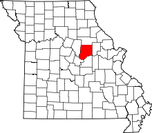 | |
| Village | ||
| Townships | ||
| Unincorporated communities | ||
| Ghost towns | ||
| Footnotes | ‡This populated place also has portions in an adjacent county or counties | |