East Fulton Township, Callaway County, Missouri
| East Fulton Township | |
|---|---|
| Township | |
 | |
| Coordinates: 38°51′12″N 091°55′48″W / 38.85333°N 91.93000°WCoordinates: 38°51′12″N 091°55′48″W / 38.85333°N 91.93000°W | |
| Country | United States |
| State | Missouri |
| County | Callaway |
| Area | |
| • Total | 67.04 sq mi (173.64 km2) |
| • Land | 66.85 sq mi (173.13 km2) |
| • Water | 0.2 sq mi (0.51 km2) 0.29% |
| Elevation[1] | 791 ft (241 m) |
| Population (2010) | |
| • Total | 10,231 |
| • Density | 150/sq mi (59/km2) |
| FIPS code | 29-20854[2] |
| GNIS feature ID | 0766377 |
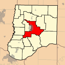
East Fulton Township is one of eighteen townships in Callaway County, Missouri, USA. As of the 2010 census, its population was 10,231.[3]
Geography
East Fulton Township covers an area of 67.04 square miles (173.6 km2) and contains the east portion of the city of Fulton (the county seat). It contains seven cemeteries: Dunlap, Guerrart, Hillcrest, Kibby, Muir, Southside and United Brethren.
The streams of Booth Branch, Cow Creek, Craghead Branch, Crows Fork Creek, Dunlap Creek, Rockhouse Creek, Smith Branch and Youngs Creek run through this township.
References
- ↑ "US Board on Geographic Names". United States Geological Survey. 2007-10-25. Retrieved 2008-01-31.
- ↑ "American FactFinder". United States Census Bureau. Archived from the original on 2013-09-11. Retrieved 2008-01-31.
- ↑ "Race, Hispanic or Latino, Age, and Housing Occupancy: 2010 Census Redistricting Data (Public Law 94-171) Summary File (QT-PL), East Fulton township, Callaway County, Missouri". U.S. Census Bureau, American FactFinder 2. Archived from the original on September 11, 2013. Retrieved October 31, 2011.
External links
Municipalities and communities of Callaway County, Missouri, United States | ||
|---|---|---|
| Cities | 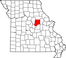 | |
| Village | ||
| Townships | ||
| Unincorporated communities | ||
| Ghost towns | ||
| Footnotes | ‡This populated place also has portions in an adjacent county or counties | |
This article is issued from
Wikipedia.
The text is licensed under Creative Commons - Attribution - Sharealike.
Additional terms may apply for the media files.