Indian Head, Maryland
| Indian Head, Maryland | |
|---|---|
| Town | |
 Location of Indian Head, Maryland | |
| Coordinates: 38°35′52″N 77°9′25″W / 38.59778°N 77.15694°WCoordinates: 38°35′52″N 77°9′25″W / 38.59778°N 77.15694°W | |
| Country |
|
| State |
|
| County | Charles |
| Incorporated | 1920[1] |
| Government | |
| • Mayor | Brandon Paulin |
| Area[2] | |
| • Total | 1.23 sq mi (3.19 km2) |
| • Land | 1.23 sq mi (3.19 km2) |
| • Water | 0 sq mi (0 km2) |
| Elevation | 105 ft (32 m) |
| Population (2010)[3] | |
| • Total | 3,844 |
| • Estimate (2016)[4] | 3,824 |
| • Density | 3,100/sq mi (1,200/km2) |
| Time zone | UTC-5 (Eastern (EST)) |
| • Summer (DST) | UTC-4 (EDT) |
| ZIP code | 20640 |
| Area code | 301 |
| FIPS code | 24-41500 |
| GNIS feature ID | 0590532 |
| Website |
www |
Indian Head is a town in Charles County, Maryland, United States. The population was 3,844 at the 2010 U.S. Census.[5] It has been the site of a naval base specializing in gun and rocket propellants since 1890.[6] Production of nitrocellulose and smokeless powder began at the Indian Head Powder Factory in 1900.[7] The name of the base has varied over the years from Indian Head Proving Ground, to Naval Powder Factory, to Naval Propellant Plant, to Naval Ordnance Station, to the present Naval Support Facility Indian Head. The facility's main tenant activity is the Indian Head Naval Surface Warfare Center (NSWC/IH). Advanced research in energetic systems takes place at NSWC/IH. NSWC/IH absorbed the function of the closed Naval Ordnance Laboratory, formerly in White Oak, Maryland. The base currently employs 3,700 people.
History
The peninsula, a "head" of land overlooking the Potomac River, had been long occupied by various cultures of indigenous peoples. The historic Algonquian-speaking American Indian tribe was the Mattawoman (likely a band of the Piscataway) encountered by the first English settlers; the latter called the land "Indian Head", meaning "Indian Peninsula".
American Civil War
During the American Civil War, Union Brigadier General Joseph Hooker commanded the Third Brigade near Budd's Ferry in August 1861. The site was a gathering spot for volunteers, including the 5th New Jersey Volunteer Infantry under Colonel Samuel H. Starr. The site was also used by the Union Army Balloon Corps for reconnaissance of Confederate troop movements across the Potomac.[8][9]
Incorporation
The town of Indian Head was incorporated in 1920. It is located between the Potomac River and Mattawoman Creek on Mattawoman/Cornwallis Neck, named for the 1654 grant of 5,000 acres (20 km2) by Cecil Calvert, 2nd Baron Baltimore, to Capt. Thomas Cornwallis of St. Mary's County. This land grant included the 2,000-acre (8.1 km2) Cornwallis Manor on the Potomac, presumably the Indian Head site, with St. Elizabeth's Manor of 2,000 acres (8.1 km2) "nearby but detached".[10] The Town of Indian Head occupies land that was once part of the territory of the Algonquin Indians. The origin of the name Indian Head originates from the term "Indian Headlands", as the entire lower end of the peninsula was occupied by Native Americans and was an Indian Reservation. The name Indian Head first appears in the Census of 1800. In 1850, the Washington Fruit Growers Association purchased a parcel of land, which included Indian Head and "Glymont". Charles Pye offered for sale, a parcel of land (664 acres) known as Glymont, On December 2, 1834. The same 664 acres was put up for sale again on July 22, 1843, after the death of Charles Pye. The two tracts land was purchased by The Glymont Improvement Company and recorded on March 20, 1887. The land (540 acres) was owned by B.D. Tubman and known as "Glymont". The second tract called “Cornwallis Neck”, and sometimes known as “Pye’s Wharf Estate” adjoin the lands of S. H. Cox and R. A. Chapman, the first-mentioned tract and others containing 480 acres of land, more or less. Glymont, with Pye's Wharf and Leonard Marbury's Wharf, were the largest river port in Charles County. The name "Indian Head" applies to the land west of Glymont. The name Indian Head first appears in the 1800 Census and dates to the establishment of the powder factory.[11]
Indian Head was a thriving small town during the World War II years and up until the late 1960s. The construction of St. Charles, a giant planned community south of nearby Waldorf, brought with it retail chains and big-box stores. These attracted Indian Head's shopping dollars and started the demise of local businesses.
Today, Indian Head is rich in history but is lacking many basic retail and service businesses.[12] Many remedies for this situation have been attempted, but the desired growth has been slow in coming. Indian Head is bisected by Maryland Route 210, generally known as Indian Head Highway. It goes directly into the middle of town at the entrance to Indian Head Naval Support Facility. Because of this, the town cannot benefit from through-traffic, but must be a destination in its own right.
Private plans to build a massive "Chapman's Landing" housing development a few miles to the north were thwarted in the 1990s when the state government purchased the land to preserve it as green space under its "smart growth" program. The preserved land includes an old growth Shell-Marl Ravine Forest ecosystem.
The town recently opened a "black box" stage theater, the Indian Head Center for the Arts, a new community center building, new ball fields, and is exploring other efforts to revitalize the town. A section of the railroad to the naval facility, built in 1918, was converted to a paved hiking/biking trail in 2008.[13] A year-round swimming pool is at the nearby Henry E. Lackey High School. In 2018 the long-abandoned Elys' store was demolished, with plans to build a technology education center on the site, linked to the Naval base.
December 2004 arson
On December 4, 2004, an arson event took place in the development of Hunters Brooke, located a few miles southeast of Indian Head. It became the largest residential arson[14] in the history of the state of Maryland.[15][16][17]
Youngest mayor
In 2015, Brandon Paulin was elected mayor of Indian Head. Brandon was 19 years of age when he was elected, making him the youngest mayor of any Maryland municipality in state history. Kiran (Ron) Sitoula, was elected as a Vice Mayor and he was the first Nepali to be elected in public position outside of Nepal and a first non-native to be elected in council in the history of the Town of Indian Head. Councilman Curtis L. Smith is the first African American male to be elected in the history of the Town.[18] Brandon was elected on 5 May 2015 and sworn into office on 12 May 2015.[19]
Geography
Indian Head is located at 38°35′52″N 77°9′25″W / 38.59778°N 77.15694°W (38.597781, -77.156926).[20]
According to the United States Census Bureau, the town has a total area of 1.23 square miles (3.19 km2), all of it land.[2]
Demographics
| Historical population | |||
|---|---|---|---|
| Census | Pop. | %± | |
| 1930 | 1,240 | — | |
| 1940 | 1,104 | −11.0% | |
| 1950 | 491 | −55.5% | |
| 1960 | 780 | 58.9% | |
| 1970 | 1,350 | 73.1% | |
| 1980 | 1,381 | 2.3% | |
| 1990 | 3,531 | 155.7% | |
| 2000 | 3,422 | −3.1% | |
| 2010 | 3,844 | 12.3% | |
| Est. 2016 | 3,824 | [4] | −0.5% |
| U.S. Decennial Census[21] | |||
2010 census
As of the census[3] of 2010, there were 3,844 people, 1,391 households, and 995 families residing in the town. The population density was 3,125.2 inhabitants per square mile (1,206.6/km2). There were 1,554 housing units at an average density of 1,263.4 per square mile (487.8/km2). The racial makeup of the town was 35.9% White, 55.5% African American, 1.3% Native American, 2.6% Asian, 0.1% Pacific Islander, 0.8% from other races, and 3.8% from two or more races. Hispanic or Latino of any race were 3.0% of the population.
There were 1,391 households of which 44.0% had children under the age of 18 living with them, 40.6% were married couples living together, 25.6% had a female householder with no husband present, 5.3% had a male householder with no wife present, and 28.5% were non-families. 22.6% of all households were made up of individuals and 3.7% had someone living alone who was 65 years of age or older. The average household size was 2.76 and the average family size was 3.24.
The median age in the town was 33.2 years. 28.2% of residents were under the age of 18; 10.5% were between the ages of 18 and 24; 30.4% were from 25 to 44; 23.6% were from 45 to 64; and 7.4% were 65 years of age or older. The gender makeup of the town was 47.3% male and 52.7% female.
2000 census
As of the census[22] of 2000, there were 3,422 people, 1,222 households, and 888 families residing in the town. The population density was 2,792.7 people per square mile (1,074.2/km²). There were 1,311 housing units at an average density of 1,069.9 per square mile (411.5/km²). The racial makeup of the town was 55.64% White, 38.08% African American, 1.78% Native American, 1.43% Asian, 0.03% Pacific Islander, 0.47% from other races, and 2.57% from two or more races. Hispanic or Latino of any race were 1.69% of the population.
There were 1,222 households out of which 44.3% had children under the age of 18 living with them, 43.5% were married couples living together, 22.9% had a female householder with no husband present, and 27.3% were non-families. 21.1% of all households were made up of individuals and 5.8% had someone living alone who was 65 years of age or older. The average household size was 2.80 and the average family size was 3.26.
In the town, the age distribution of the population shows 33.0% under the age of 18, 8.4% from 18 to 24, 34.3% from 25 to 44, 16.7% from 45 to 64, and 7.6% who were 65 years of age or older. The median age was 31 years. For every 100 females, there were 94.3 males. For every 100 females age 18 and over, there were 87.0 males.
The median income for a household in the town was $42,702, and the median income for a family was $48,375. Males had a median income of $35,625 versus $31,451 for females. The per capita income for the town was $18,778. About 9.9% of families and 11.5% of the population were below the poverty line, including 13.9% of those under age 18 and 11.8% of those age 65 or over.
References
- ↑ "Indian Head". Maryland Manual. Retrieved 25 June 2017.
- 1 2 "US Gazetteer files 2010". United States Census Bureau. Archived from the original on January 24, 2012. Retrieved 2013-01-25.
- 1 2 "American FactFinder". United States Census Bureau. Retrieved 2013-01-25.
- 1 2 "Population and Housing Unit Estimates". Retrieved June 9, 2017.
- ↑ "Profile of General Population and Housing Characteristics: 2010 Demographic Profile Data (DP-1): Indian Head town, Maryland". U.S. Census Bureau, American Factfinder. Archived from the original on September 11, 2013. Retrieved August 3, 2012.
- ↑ "Indian Head Proving Ground; Where Uncle Sam Tests His Big Guns and Armor Plate". The New York Times. April 15, 1894. Retrieved 2008-01-20.
- ↑ Worden, Edward C., Nitrocellulose industry: a compendium of the history, chemistry, manufacture, D. Van Nostrand Co., 1911.
- ↑ Foster, John Y. New Jersey and the Rebellion (1868), pg 130
- ↑ Budd's Ferry Marker
- ↑ Wilstach, Paul, Potomac Landings, Doubleday, Garden City, New Jersey, p.69 (1920).
- ↑ The Evening Star, December 2, 1834; The Alexandria Gazette, December 23, 1848.
- ↑ N.B. McConaty, "Business attraction is main issue in Indian Head election", Maryland Independent, 15 April 2009
- ↑ N.B. McConaty, "Rails to trails project chugs ahead", Maryland Independent, 23 July 2008
- ↑ United States Attorney for the District of Maryland (2006-03-01). "Violent Crime Program 2005 Annual Report" (PDF). United States Department of Justice. Archived from the original (PDF) on 2010-08-29. Retrieved 2010-08-02.
- ↑ Courson, Paul; Jonathan Wild (2004-12-21). "Two more arrested in Maryland fires". Washington, DC: CNN. p. 1. Retrieved 2 August 2010.
- ↑ Witte, Brian (January 3, 2005). "Maryland Hunts for Motives Behind State's Largest Residential Arson". Insurance Journal. Retrieved 2 August 2010.
- ↑ Hancock, David (Dec 18, 2004). "3 More Charged In Maryland Arson". La Plata, Md: CBS NEWS. p. 1. Retrieved 2 August 2010.
- ↑ http://www.nbcwashington.com/news/local/Brandon-Paulin-Youngest-Mayor-in-Maryland-History-to-Be-Sworn-In-303473501.html
- ↑ https://www.washingtonpost.com/local/dc-politics/youngest-elected-mayor-in-maryland-to-be-sworn-into-office/2015/05/11/c0e8f2c4-f7cf-11e4-9ef4-1bb7ce3b3fb7_story.html
- ↑ "US Gazetteer files: 2010, 2000, and 1990". United States Census Bureau. 2011-02-12. Retrieved 2011-04-23.
- ↑ "Census of Population and Housing". Census.gov. Archived from the original on May 12, 2015. Retrieved June 4, 2015.
- ↑ "American FactFinder". United States Census Bureau. Archived from the original on September 11, 2013. Retrieved 2008-01-31.
- Warren, Kathy (Winter 2002). "Indian Head – Land of Legend and Military Might". 4. Southern Maryland This is Living. Retrieved 2012-08-14.
External links
| Wikimedia Commons has media related to Indian Head, Maryland. |
- Town of Indian Head official website
- Indian Head Rail Trail at Everytrail.com
- Naval Support Activity, South Potomac
- Cullinan, Kathleen (April 29, 2005). "Town of Indian Head Plans Future With or Without Nearby Base". Maryland Newsline. Retrieved 2008-02-03.
Municipalities and communities of Charles County, Maryland, United States | ||
|---|---|---|
| Towns | 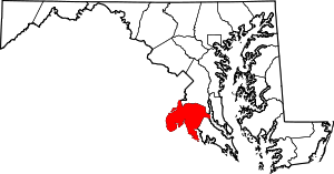 | |
| CDPs | ||
| Other communities | ||
| Principal cities |
|   | ||||||
|---|---|---|---|---|---|---|---|---|
| Counties and county equivalents* |
| |||||||
The District of Columbia itself, and Virginia's incorporated cities, are county equivalents. Virginia's incorporated cities are listed under their surrounding county. The incorporated cities bordering more than one county (Alexandria, Falls Church and Fredericksburg) are listed under the county they were part of before incorporation as a city. | ||||||||