Cobb Island (Maryland)
| Cobb Island, Maryland | |
|---|---|
| Census-designated place | |
 Location of Cobb Island, Charles County, Maryland | |
| Coordinates: 38°15′30″N 76°50′38″W / 38.25833°N 76.84389°WCoordinates: 38°15′30″N 76°50′38″W / 38.25833°N 76.84389°W | |
| Country | United States |
| State | Maryland |
| County | Charles |
| Area | |
| • Total | 0.9 sq mi (2.4 km2) |
| • Land | 0.6 sq mi (1.6 km2) |
| • Water | 0.3 sq mi (0.8 km2) |
| Elevation[1] | 10 ft (3 m) |
| Population (2010) | |
| • Total | 1,166 |
| • Density | 1,300/sq mi (490/km2) |
| Time zone | UTC-5 (Eastern (EST)) |
| • Summer (DST) | UTC-4 (EDT) |
| ZIP code | 20625 |
| GNIS feature ID | 1988529[1] |
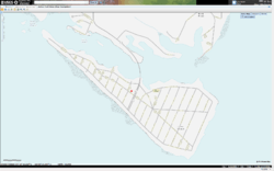
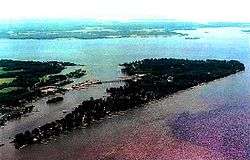
Cobb Island is a small island located at the confluence of the Potomac River and the Wicomico River in southern Charles County, Maryland in the United States.[2] It is located approximately 45 miles (72 km) south of Washington, D.C., and is considered to be within the Washington, D.C. MSA. Cobb Island is separated from the mainland by Neale Sound and connected to it by a 0.11-mile-long (180 m)[3] fixed bridge carrying Maryland Route 254.
The unincorporated community and census-designated place (CDP) of Cobb Island is located on the island. As of the 2010 census, the CDP had a population of 1,166.[4] The community has a small post office, a volunteer fire department and rescue squad,[5] a Baptist church, a large community green space (Fisherman's Field) and a small playground for children. Commercially, there are two seafood restaurants with marinas (Captain John's Crab House, and Shymansky's Restaurant & Marina), The Rivah, a marina with a pizzeria restaurant chain (Ledo Pizza), a small bar and grill (The Scuttlebutt), a seasonal coffee shop, art gallery & bakery (The Cove at Cobb Island), and a small market (Cobb Island Market).
Historical notes
On December 23, 1900, Reginald Aubrey Fessenden sent and received the first intelligible speech by electromagnetic waves on a pair of masts 50 feet (15 m) high and 1 mile (1.6 km) apart on Cobb Island.[6] Fessenden was using a spark transmitter with the Kintner-Brashear interrupter.[7]
References
- 1 2 "US Board on Geographic Names". United States Geological Survey. 2007-10-25. Retrieved 2008-01-31.
- ↑ U.S. Geological Survey Geographic Names Information System: Cobb Island (Maryland)
- ↑ "Highway Location Reference: Charles County" (PDF). Maryland State Highway Administration. 2010. Retrieved 2011-10-03.
- ↑ "Profile of General Population and Housing Characteristics: 2010 Demographic Profile Data (DP-1): Cobb Island CDP, Maryland". U.S. Census Bureau, American Factfinder. Archived from the original on September 11, 2013. Retrieved August 3, 2012.
- ↑ "Cobb Island Volunteer Fire Department & EMS - Charles County, Company 6". Retrieved 3 October 2011.
- ↑ Belrose, John S. (September 1994). "Fessenden and the Early History of Radio Science". The Radioscientist. 5 (3). Retrieved 3 October 2011.
- ↑ On the Birth of Wireless Telephony, John S. Belrose
External links

- Cobb Island Official FACEBOOK page
- Census information about Cobb Island, MD 20625
- Gaines, Patrice (August 20, 1994). "Cobb Island: The Water Offers An Everyday Escape". The Washington Post. Retrieved 2008-10-17.
Municipalities and communities of Charles County, Maryland, United States | ||
|---|---|---|
| Towns | 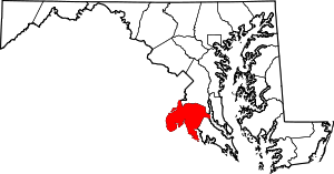 | |
| CDPs | ||
| Other communities | ||