Houghton Meadows
| Site of Special Scientific Interest | |
 | |
| Area of Search | Cambridgeshire |
|---|---|
| Grid reference | TL 293 716 [1] |
| Interest | Biological |
| Area | 4.7 hectares[1] |
| Notification | 1984[1] |
| Location map | Magic Map |
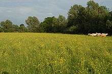
Houghton Meadows is a 4.7 hectare biological Site of Special Scientific Interest (SSSI) between Houghton and St Ives in Cambridgeshire.[1][2] The SSSI covers three meadows south of Thicket Road; they are part of the 8 hectare Houghton Meadows nature reserve, which is owned and managed by the Wildlife Trust for Bedfordshire, Cambridgeshire and Northamptonshire, and which also includes Browns Meadow to the south.[3][4]
Some of these fields are pasture and others are hay meadows, and they display ridges and furrows from medieval ploughing. They are a type of neutral grassland which is declining nationally. Flowers include cowslips and yellow-rattles, and there are fauna such as green woodpeckers and great crested newts.[3][5]
There is access from the Ouse Valley Way, which runs along Thicket Road.
References
- 1 2 3 4 "Designated Sites View: Houghton Meadows". Sites of Special Scientific Interest. Natural England. Retrieved 11 December 2016.
- ↑ "Map of Houghton Meadows". Sites of Special Scientific Interest. Natural England. Retrieved 11 December 2016.
- 1 2 "Houghton Meadows". Wildlife Trust for Bedfordshire, Cambridgeshire and Northamptonshire. Retrieved 11 December 2016.
- ↑ "History of Houghton Meadows" (PDF). Huntingdonshire Fauna and Flora Scoiety. 2008. Retrieved 11 December 2016.
- ↑ "Houghton Meadows citation" (PDF). Sites of Special Scientific Interest. Natural England. Retrieved 11 December 2016.