Fleam Dyke
| Site of Special Scientific Interest | |
 Fleam Dyke approaching Mutlow Hill | |
| Area of Search | Cambridgeshire |
|---|---|
| Grid reference | TL 551 539 [1] |
| Interest | Biological |
| Area | 7.8 hectares[1] |
| Notification | 1984[1] |
| Location map | Magic Map |
Fleam Dyke is a 7.8 hectare biological Site of Special Scientific Interest between Fulbourn and Balsham in Cambridgeshire.[1][2] It is also a Scheduled Monument.[3] If formed a boundary of the late Saxon, pre-Norman administrative division of Flendish Hundred.
History
The dyke is a seven-metre-high linear bank and ditch which ran from Fulbourn to Balsham. Most of it survives and is now a footpath. In the nineteenth and early twentieth centuries Anglo-Saxon weapons and burials were found, and the dyke was thought to have been built in the seventh century as a defence of the Kingdom of East Anglia in its wars with Mercia.
An excavation in 1991 established that it had been built in several phases, the first between 330 and 510, and the last between 450 and 620. It is now believed most likely to have been built by early Anglo-Saxon settlers in the fifth century as a defence against Romano-British attempts to recover their territory.
At Mutlow Hill the dyke runs through a Bronze Age barrow, which was reused in the Roman period as a temple.[4]
Construction
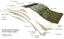
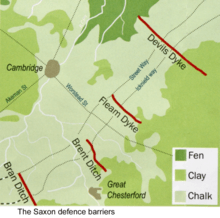
Fleam Dyke is one of several barriers that were built along Icknield Way and Street Way by Anglo-Saxon immigrants. Their purpose was to defend their core settlements in eastern Cambridgeshire, Norfolk and Suffolk against Romano-British counterattacks in the 5th century AD.
Icknield Way may be unremarkable nowadays but it is of huge historical importance. It is certainly a pre-Roman path often claimed as the oldest in England and was later named one of the Four Highways of medieval England on which travellers had royal protection. To that extent, Fleam Dyke, Flendish Hundred and Fulbourn have their place in history.
Ecology
Fleam Dyke is one of 286 sites selected by Charles Rothschild in 1912 to 1915 as wildlife sites "worthy of preservation" in Britain and Ireland.[5][6] The steep banks of the earthwork have species-rich chalk grassland, a rare habitat in the county. The dyke, which is maintained by grass cutting, is the only Cambridgeshire site for the common juniper.[7]
The Harcamlow Way long distance footpath runs through the site.
References
- 1 2 3 4 "Designated Sites View: Fleam Dyke". Sites of Special Scientific Interest. Natural England. Retrieved 6 December 2016.
- ↑ "Map of Fleam Dyke". Sites of Special Scientific Interest. Natural England. Retrieved 6 December 2016.
- ↑ "Fleam Dyke: List entry Number 1006931". Historic England. Retrieved 6 December 2016.
- ↑ Malim, Tim. "Fleam Dyke". Friends of the Roman Road and Fleam Dyke. Retrieved 6 December 2016.
- ↑ "The Rothschild Reserves: About the Archive". The Wildlife Trusts. Retrieved 6 December 2016.
- ↑ "The Rothschild Reserves: Fleam Dyke". The Wildlife Trusts. Retrieved 6 December 2016.
- ↑ "Fleam Dyke citation" (PDF). Sites of Special Scientific Interest. Natural England. Retrieved 6 December 2016.
| Wikimedia Commons has media related to Fleam Dyke. |