Chettisham Meadow
| Site of Special Scientific Interest | |
 | |
| Area of Search | Cambridgeshire |
|---|---|
| Grid reference | TL 541 830 [1] |
| Interest | Biological |
| Area | 0.7 hectares[1] |
| Notification | 1983[1] |
| Location map | Magic Map |
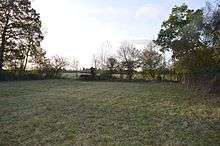
Chettisham Meadow is a 0.7 hectare biological Site of Special Scientific Interest west of Chettisham in Cambridgeshire.[1][2] It is managed by the Wildlife Trust for Bedfordshire, Cambridgeshire and Northamptonshire.[3]
The site is grassland on calcareous clay, and evidence survives of ridge and furrow medieval farming. Flowering plants include adder's tongue, cowslip and the uncommon green-winged orchid.[4]
There is access from Church Farm on the road called The Hamlet, by a track which goes under the A10, and curves to meet the track called The Balk. A footpath from the point where the two tracks meet leads to the reserve entrance.
References
- 1 2 3 4 "Designated Sites View: Chettisham Meadow". Sites of Special Scientific Interest. Natural England. Retrieved 14 November 2016.
- ↑ "Map of Chettisham Meadow". Sites of Special Scientific Interest. Natural England. Retrieved 14 November 2016.
- ↑ "Chettisham Meadow". Wildlife Trust for Bedfordshire, Cambridgeshire and Northamptonshire. Retrieved 14 November 2016.
- ↑ "Chettisham Meadow citation" (PDF). Sites of Special Scientific Interest. Natural England. Archived from the original (PDF) on 3 March 2016. Retrieved 14 November 2016.
| Wikimedia Commons has media related to Chettisham Meadow. |
This article is issued from
Wikipedia.
The text is licensed under Creative Commons - Attribution - Sharealike.
Additional terms may apply for the media files.