Highland Township, Vermillion County, Indiana
| Highland Township | |
|---|---|
| Township | |
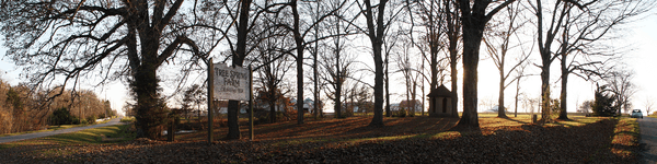 Tree Spring in northeastern Highland Township | |
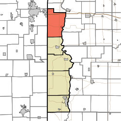 Location in Vermillion County | |
| Coordinates: 40°04′46″N 87°28′32″W / 40.07944°N 87.47556°WCoordinates: 40°04′46″N 87°28′32″W / 40.07944°N 87.47556°W | |
| Country | United States |
| State | Indiana |
| County | Vermillion |
| Government | |
| • Type | Indiana township |
| Area | |
| • Total | 55.07 sq mi (142.6 km2) |
| • Land | 54.54 sq mi (141.3 km2) |
| • Water | 0.53 sq mi (1.4 km2) 0.96% |
| Elevation[1] | 623 ft (190 m) |
| Population (2010) | |
| • Total | 1,534 |
| • Density | 28.1/sq mi (10.8/km2) |
| Time zone | UTC-5 (Eastern (EST)) |
| • Summer (DST) | UTC-4 (EDT) |
| ZIP codes | 47928, 47932, 47974 |
| Area code(s) | 765 |
| GNIS feature ID | 453413 |
Highland Township is one of five townships in Vermillion County, Indiana, United States. As of the 2010 census, its population was 1,534 and it contained 724 housing units.[2]
Geography
According to the 2010 census, the township has a total area of 55.07 square miles (142.6 km2), of which 54.54 square miles (141.3 km2) (or 99.04%) is land and 0.53 square miles (1.4 km2) (or 0.96%) is water.[2]
Cities
Unincorporated towns
- Flat Iron at 40°03′12″N 87°29′24″W / 40.0533708°N 87.4900163°W
- Gessie at 40°04′57″N 87°29′59″W / 40.0825372°N 87.4997387°W
- Rileysburg at 40°06′15″N 87°31′33″W / 40.1042037°N 87.5258506°W
- Tree Spring at 40°05′48″N 87°25′59″W / 40.0967045°N 87.4330703°W
(This list is based on USGS data and may include former settlements.)
Cemeteries
The township contains eight cemeteries: Ater, Chenoweth, Harrison, Hicks, Hopewell, Hughes, Lower Mound and Smith.
Airports and landing strips
- Highland Airport (closed)
Rivers
Highways
School districts
- North Vermillion Community School Corporation
Political districts
- Indiana's 8th congressional district
- State House District 42
- State Senate District 38
References
- ↑ "US Board on Geographic Names". United States Geological Survey. October 25, 2007. Retrieved 2017-05-09.
- 1 2 "Population, Housing Units, Area, and Density: 2010 - County -- County Subdivision and Place -- 2010 Census Summary File 1". United States Census. Retrieved 2013-05-10.
External links
Places adjacent to Highland Township, Vermillion County, Indiana | |
|---|---|
Municipalities and communities of Vermillion County, Indiana, United States | ||
|---|---|---|
| City | ||
| Towns | ||
| Townships | ||
| CDPs | ||
| Other unincorporated communities | ||
| Ghost towns | ||
| Footnotes | ‡This populated place also has portions in an adjacent county or counties | |
This article is issued from
Wikipedia.
The text is licensed under Creative Commons - Attribution - Sharealike.
Additional terms may apply for the media files.