Benxi Manchu Autonomous County
| Benxi County 本溪县 ᠪᡝᠨᠰᡳ ᠰᡳᠶᠠᠨ | |
|---|---|
| Autonomous county | |
|
本溪满族自治县 ᠪᡝᠨᠰᡳ ᠮᠠᠨᠵᡠ ᠪᡝᠶᡝ ᡩᠠᠰᠠᠩᡤᠠ ᠰᡳᠶᠠᠨ Benxi Manchu Autonomous County | |
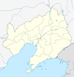
 Location of Benxi County jurisdiction within Benxi City | |
 Benxi County Location of the seat in Liaoning | |
| Coordinates: 41°18′N 124°07′E / 41.300°N 124.117°ECoordinates: 41°18′N 124°07′E / 41.300°N 124.117°E | |
| Country | People's Republic of China |
| Province | Liaoning |
| Prefecture-level city | Benxi |
| County seat | Xiaoshi |
| Area | |
| • Total | 3,362 km2 (1,298 sq mi) |
| Elevation | 205 m (673 ft) |
| Population (2002) | |
| • Total | 300,000 |
| • Density | 89/km2 (230/sq mi) |
| Time zone | UTC+8 (China Standard) |
| Postal code | 117100 |
| Area code(s) | 0414 |
Benxi Manchu Autonomous County (simplified Chinese: 本溪满族自治县; traditional Chinese: 本溪滿族自治縣; pinyin: Běnxī Mǎnzú Zìzhìxiàn; Manchu: ᠪᡝᠨᠰᡳ
ᠮᠠᠨᠵᡠ
ᠪᡝᠶᡝ
ᡩᠠᠰᠠᠩᡤᠠ
ᠰᡳᠶᠠᠨ
; Mölendroff: bensi manju beye dasangga siyan) is an autonomous county under the administration of the prefecture-level city Benxi, in the east of Liaoning province, China. It has a total area of 3,362 square kilometres (1,298 sq mi), and a population of approximately 300,000 people as of 2002.
Administrative divisions
There is one subdistrict, 11 towns, and 1 townships within the county:[1]
The only subdistrict is Guanyinge Subdistrict (观音阁街道)
Towns:
- Xiaoshi (小市镇), Tianshifu (田师傅镇), Caohekou (草河口镇), Lianshanguan (连山关镇), Qinghecheng (清河城镇), Nandian (南甸镇), Jianchang (碱厂镇), Caohecheng (草河城镇), Pianling (偏岭镇), Caohezhang (草河掌镇), Gaoguan (高官镇)
The only township is Dongyingfang Township (东营房乡)
References
- ↑ 2011年统计用区划代码和城乡划分代码:本溪县 (in Chinese). National Bureau of Statistics of the People's Republic of China. Retrieved 2012-12-25.
External links
| Counties |
|    | ||||||
|---|---|---|---|---|---|---|---|---|
| ||||||||
This article is issued from
Wikipedia.
The text is licensed under Creative Commons - Attribution - Sharealike.
Additional terms may apply for the media files.