Mukutmanipur
| Mukutmanipur | |
|---|---|
| Village | |
 Mukutmanipur Location in West Bengal, India  Mukutmanipur Mukutmanipur (India) | |
| Coordinates: 22°56′58″N 86°48′17″E / 22.9495810°N 86.8046520°ECoordinates: 22°56′58″N 86°48′17″E / 22.9495810°N 86.8046520°E | |
| Country |
|
| State | West Bengal |
| District | Bankura |
| Population (2011) | |
| • Total | 447 |
| Languages | |
| • Official | Bengali, English |
| Time zone | UTC+5:30 (IST) |
| Vehicle registration | WB |
| Website |
wb |
Mukutmanipur is a town in Bankura district of West Bengal, India. It is located at the confluence of the Kangsabati and Kumari rivers close to the Jharkhand border.
Geography
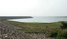
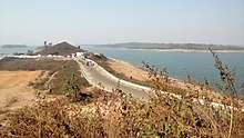
Kangsabati project
In 1956, a giant water dam reservoir was planned at Mukutmanipur, [about 12 km from Khatra town in the district of Bankura, WB], under a big vision mooted by the then CM of Bengal Dr Bidhan Ch. Roy. The Mukutmanipur dam was planned to provide major irrigation facilities to 8,000 square kilometres of agricultural land, stretched across Bankura, Purulia, Paschim Medinipur and parts of upper Hooghly.[1] Approximately two kilometres from the lake is the Bangopalpur Reserve Forest, a home of many species of flora and fauna.
Notable attractions
Mukutmanipur and Jhilimili nearby are major tourist attractions visited by more than a lakh (100 000) visitors. The second biggest earth dam of India is located in Mukutmanipur 55 km away from Bankura. According to one description, “green forests surround the vast bluish tract of water, and the hillocks are picturesque. The place is very famous for its superb natural beauty. The undulating terrain along the southern edge of the Kangsabati water reservoir spreads as a three-dimensional necklace in green and terracotta.” The SDO, Khatra, Mr Sanjay Vansal said: “We have got a Rs 80 lakh composite UNDP project for Mukutmanipur. The project has been conceived to promote tourism and improve the condition of the tribal artisans devoted to the craft work with bamboo sticks and saboi grass.” [2]
Approximately two kilometers from the lake is the Bangopalpur Reserve Forest, a home of many species of flora and fauna. Four kilometres from the dam is the ancient town of Ambikanagar, once an important place of pilgrimage for Jains. However, a flood destroyed most of what remained in 1898.
Mukutmanipur is home to a 10.8 km-long man-made mud-banked fresh water barrage. It canalises Kangshabati and Kumari rivers into the three drought affected districts of Bankura, Purulia and Midnapore for irrigation in the summer months.
Demographics
As per 2011 Census of India Mukutmanipur had a total population of 447 of which 240 (54%) were males and 207 (46%) were females. Population below 6 years was 40. The total number of literates in Mukutmanipur was 328 (80.59% of the population over 6 years).[3]
Transport
The Union Railway Minister laid the foundation stone of the new 47 km Bankura-Chhatna-Mukutmanipur line in 2005.[4][5]
References
- ↑ The Statesman 7 September 2006 Archived 29 September 2007 at the Wayback Machine.
- ↑ The Statesman 4 January 2007 Archived 29 September 2007 at the Wayback Machine.
- ↑ "2011 Census – Primary Census Abstract Data Tables". West Bengal – District-wise. Registrar General and Census Commissioner, India. Retrieved 14 October 2016.
- ↑ The Hindu Business Line 1 January 2005
- ↑ The Hindu Business Line 21 September 2005
External links

- Calcutta English daily Telegraph review of Mukutmanipur
Cities, towns and locations in Bankura District | |||||||
|---|---|---|---|---|---|---|---|
| Cities, municipal and census towns |
| ||||||
| Locations other than cities and towns |
| ||||||
| Related topics |
| ||||||