Appalachian Trail station
Appalachian Trail | |||||||||||
|---|---|---|---|---|---|---|---|---|---|---|---|
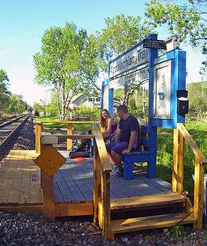 Hikers awaiting southbound train | |||||||||||
| Location |
991 Route 22 Pawling, NY, 12564 | ||||||||||
| Coordinates | 41°35′34″N 73°35′17″W / 41.5929°N 73.5880°WCoordinates: 41°35′34″N 73°35′17″W / 41.5929°N 73.5880°W | ||||||||||
| Owned by | Metropolitan Transportation Authority | ||||||||||
| Line(s) | |||||||||||
| Platforms | 1 side platform | ||||||||||
| Tracks | 1 | ||||||||||
| Other information | |||||||||||
| Fare zone | 8 | ||||||||||
| History | |||||||||||
| Opened | 1991 | ||||||||||
| Services | |||||||||||
| |||||||||||
Appalachian Trail is a Metro-North Railroad station that serves campers and hikers destined for the Appalachian Trail, north of Pawling, New York, via the Harlem Line. It is the only rail station directly located on the Appalachian Trail. Trains stop at here on Saturdays, Sundays, and holidays only. The Connecticut State line is about 7 miles (11 km) from the station. It is 65.9 miles (106.1 km) from Grand Central Terminal, which takes approximately 1 hour 52 minutes. Appalachian Trail is the northernmost station in the Zone 8 Metro-North fare zone. There are no transportation connections via bus or taxi, but NY 22 is only steps away from the station.
Description and history
The station was built in three months by Metro-North Railroad forces in 1991 for the cost of $10,000.[1] Its creation was the suggestion of George Zoebelein, who was an avid hiker and a veteran of the NY/NJ Trail Conference as well as both the NY/NJ Appalachian Trail Conferences, and also served as a member of the Metro-North Railroad Commuter Council (MNRCC) of the Permanent Citizens Advisory Committee (PCAC) to the Metropolitan Transportation Authority. It is one of three limited service stops operated by Metro-North primarily for hikers, the other two being Breakneck Ridge and Manitou on the Hudson Line.
The trail itself crosses the track just south of the station. In the northbound direction, it leads immediately to a small grassy parking area along Route 22 with space for a few cars, then follows the highway to paved turnouts with more space a few hundred feet north along either side of the highway, just north of where it leaves the road and starts climbing toward Hammersly Ridge and the Pawling Nature Preserve. South of the station the trail crosses a swampy area and then climbs a smaller ridge.
Station layout
The station has a low-level wooden side platform to the east of the track, long enough for one door of one car to receive and discharge passengers. The platform has no shelter, but has a bulletin board for posting the current train schedule, as well as information for hikers.
| P Platform level |
Track 1 | ← Harlem Line limited service toward Southeast or Grand Central (Pawling) Harlem Line limited service toward Wassaic (Harlem Valley–Wingdale) → |
| Side platform, doors will open on the left or right | ||
| Street level | Access to Appalachian Trail and Route 22 | |
References
- ↑ Pollak, Michael (June 23, 1996). "For Hikers, The Train To the Trail". New York Times. Retrieved February 21, 2010.