Calumet Township, Michigan
| Calumet Township, Michigan | |
|---|---|
| Charter township | |
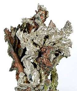 Silver and copper mineral specimen from the old Wolverine Mine | |
 Calumet Township Location within the state of Michigan  Calumet Township Calumet Township (the US) | |
| Coordinates: 47°14′58″N 88°26′41″W / 47.24944°N 88.44472°WCoordinates: 47°14′58″N 88°26′41″W / 47.24944°N 88.44472°W | |
| Country | United States |
| State | Michigan |
| County | Houghton |
| Area | |
| • Total | 33.3 sq mi (86.2 km2) |
| • Land | 33.2 sq mi (85.9 km2) |
| • Water | 0.1 sq mi (0.3 km2) |
| Elevation | 1,191 ft (363 m) |
| Population (2010) | |
| • Total | 6,489 |
| • Density | 196/sq mi (75.6/km2) |
| Time zone | UTC-5 (Eastern (EST)) |
| • Summer (DST) | UTC-4 (EDT) |
| ZIP codes | 49913, 49942 |
| Area code(s) | 906 |
| FIPS code | 26-12600[1] |
| GNIS feature ID | 1626023[2] |
| Website |
calumettownship |
Calumet Township (/ˌkæljʊˈmɛt/ KAL-yuu-MET) is a charter township of Houghton County in the U.S. state of Michigan. The population was 6,489 at the 2010 census,[1] down from 6,997 at the 2000 census.
History
Native Americans mined copper in Calumet Township thousands of years ago.
Calumet Township was organized in 1866.[3]
The Wolverine Mine opened in 1882. Large-scale production began in 1890. The mine closed in 1925. The old Wolverine Mine is famous among mineral collectors for copper, silver, epidote, and quartz specimens.[4]
Communities
- Albion Station is an unincorporated community in the township
- Blue Jacket is an unincorporated community in the township
- Calumet is an incorporated village in the township.
- Centennial is a community in the township
- Centennial Heights is a community in the township
- Desjardins Ville is an unincorporated community in the township
- Hecla is an unincorporated community in the township
- Kearsarge is an unincorporated community in the township
- Lakeview is an unincorporated community in the township
- Laurium is an incorporated village in the township.
- Phillipsville is an unincorporated community in the township
- Raymbaultown is an unincorporated community in the township
- Swedetown is an unincorporated community in the township
- Wolverine, an unincorporated community at 47°16′11″N 88°25′10″W / 47.26972°N 88.41944°W.[5] It was named for the Wolverine Mine, which opened in 1882 and at one point held sixth place among copper-producing mines on Lake Superior.[6]
Parks and recreation
Calumet Township boasts numerous recreation areas. Parks, playgrounds, fishing areas, and beaches are scattered all over the township.
Parks
- Agassiz Park (Calumet Village)
- Italian Hall Memorial (Calumet Village)
- Calumet Theater Park (Calumet Village)
- George Gipp Memorial (Laurium Village)
- Daniel Park (Laurium Village)
- Copper City Playground (Copper City Village)
- War Memorial (Kearsarge)
- Heights Park & Playground (Centennial Heights)
- Calumet Lake Park (Just outside Calumet Village)
- Calumet Waterworks Park & Beach (On Lake Superior)
Recreation areas
- Agassiz Park (Calumet Village. Basketball Court, Horseshoe Pits)
- Agassiz Field (Calumet Village. Football Field)
- Legion Field (Just outside Calumet Village. Soccer Field)
- George Gipp Recreation Area (Laurium Village. Ice Arena, Baseball Field, Basketball Courts)
- Kearsarge Park (Kearsarge. Basketball Court)
- Wolverine Field (Kearsarge. Baseball Field)
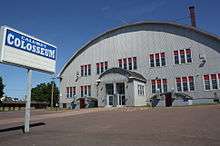
- The Calumet Colosseum (Calumet Village. Ice Arena)
- Traprock Valley Field (Traprock Valley. Baseball Field)
- Swedetown Recreation Area (Swedetown. Ski Trails, Bike Trails, Sledding Hill, Fishing Docks)
Geography
According to the United States Census Bureau, the township has a total area of 33.3 square miles (86.2 km2), of which 33.2 square miles (85.9 km2) are land and 0.1 square miles (0.3 km2), or 0.38%, are water.[1]
Demographics
| Historical population | |||
|---|---|---|---|
| Census | Pop. | %± | |
| 1870 | 3,182 | — | |
| 1880 | 8,290 | 160.5% | |
| 1890 | 12,529 | 51.1% | |
| 1900 | 25,991 | 107.4% | |
| 1910 | 32,845 | 26.4% | |
| 1920 | 22,369 | −31.9% | |
| 1930 | 16,033 | −28.3% | |
| 1940 | 13,362 | −16.7% | |
| 1950 | 10,283 | −23.0% | |
| 1960 | 9,192 | −10.6% | |
| 1970 | 8,271 | −10.0% | |
| 1980 | 7,965 | −3.7% | |
| 1990 | 7,015 | −11.9% | |
| 2000 | 6,997 | −0.3% | |
| 2010 | 6,489 | −7.3% | |
As of the census[7] of 2000, there were 6,997 people, 2,892 households, and 1,697 families residing in the township. The population density was 210.4 per square mile (81.2/km²). There were 3,573 housing units at an average density of 107.5 per square mile (41.5/km²). The racial makeup of the township was 98.37% White, 0.11% African American, 0.47% Native American, 0.13% Asian, 0.01% Pacific Islander, 0.19% from other races, and 0.71% from two or more races. Hispanic or Latino of any race were 0.89% of the population. 40.7% were of Finnish, 10.1% German, 8.1% Italian, 6.8% French and 6.2% English ancestry according to Census 2000.
There were 2,892 households out of which 26.9% had children under the age of 18 living with them, 45.9% were married couples living together, 9.4% had a female householder with no husband present, and 41.3% were non-families. 37.3% of all households were made up of individuals and 18.2% had someone living alone who was 65 years of age or older. The average household size was 2.33 and the average family size was 3.14.
In the township the population was spread out with 25.8% under the age of 18, 8.8% from 18 to 24, 23.6% from 25 to 44, 21.8% from 45 to 64, and 19.9% who were 65 years of age or older. The median age was 39 years. For every 100 females, there were 97.3 males. For every 100 females age 18 and over, there were 94.7 males.
The median income for a household in the township was $24,928, and the median income for a family was $34,236. Males had a median income of $26,985 versus $21,420 for females. The per capita income for the township was $14,711. About 11.9% of families and 17.6% of the population were below the poverty line, including 25.4% of those under age 18 and 13.8% of those age 65 or over.
References
- 1 2 3 "Geographic Identifiers: 2010 Census Summary File 1 (G001): Calumet charter township, Houghton County, Michigan". American Factfinder. U.S. Census Bureau. Retrieved August 11, 2017.
- ↑ U.S. Geological Survey Geographic Names Information System: Calumet Township, Michigan
- ↑ Walter Romig, Michigan Place Names, p. 94
- ↑ Wolverine Mine at Mindat.org
- ↑ U.S. Geological Survey Geographic Names Information System: Wolverine
- ↑ Romig, Walter (1986) [1973]. Michigan Place Names. Detroit, Michigan: Wayne State University Press. ISBN 0-8143-1838-X.
- ↑ "American FactFinder". United States Census Bureau. Archived from the original on 2013-09-11. Retrieved 2008-01-31.
External links
Municipalities and communities of Houghton County, Michigan, United States | ||
|---|---|---|
| Cities | 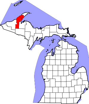 | |
| Villages | ||
| Charter townships | ||
| General law townships | ||
| CDPs | ||
| Other unincorporated communities | ||