Hajigabul District
| Hacıqabul | |
|---|---|
| Rayon | |
.svg.png) Map of Azerbaijan showing Hajigabul rayon | |
| Country | Azerbaijan |
| Capital | Qazimemmed |
| Area | |
| • Total | 1,640 km2 (630 sq mi) |
| Population (2009) | |
| • Total | 65,500 |
| Postal code | 2400 |
| Telephone code | (+994) 21[1] |
Hajigabul - (Azerbaijani: Hacıqabul) is one of the districts of Azerbaijan estableshed in 1990 by the decision of the Supreme Council of the Republic. The district is bordered by Absheron , Gobustan, Shamaxı, Aghsu, Kurdamir, Sabirabad, Salyan, and Shirvan city.
History
Hajigabul district located on the Silk Road, was part of the Arab Caliphate, Seljuk, Sacids, Hulakids, Shirvanshahs, Safavids in different times. During the division of the State into the Khanates, the district was included in the Shamakhi khanate. After joining of North Azerbaijan to Tsardom of Russia,[2] it was included in Shamakhi Uyezd of Caspian province which was established in 1830.[3] After the abolition of the Caspian province in 1841, it was included in the Shamakhi governorate. After the devastating earthquake in 1859 in Shamakhi, the capital of governorate was moved to Baku. In 1860 - 1930, Hajigabul was part of the Shamakhi Uyezd in the Baku province. On August 8, 1930, Uyezd was abolished and as a result of this, the new Garasu was established. Since November 29, 1938, city status has been awarded to Hajigabul.[4][5]
Divisions
There are 31 populated areas. One of them is a city, 1 city-like settlement, 4 settlements and 25 villages. There are 15 administrative-territorial units, 5 medical institutions and 55 cultural centers. The Pirsaat River and Prsaat valley is located in this region.[6]
Population
According to the report of Statistical Committee of republic, the number of population is 74,7 thousand at the beginning of the 2018. 37,4 thousand of them live in urban areas, 37,3 thousand people in the rural areas.[7]
| Population | 1999 | 2000 | 2001 | 2002 | 2003 | 2004 | 2005 | 2006 | 2007 | 2008 | 2009 | 2010 | 2011 | 2012 | 2013 | 2014 | 2015 | 2016 | 2017 | 2018 |
|---|---|---|---|---|---|---|---|---|---|---|---|---|---|---|---|---|---|---|---|---|
| Hajigabul region | 57,9 | 58,5 | 59,1 | 59,7 | 60,2 | 60,7 | 61,7 | 63,0 | 63,9 | 64,8 | 65,7 | 66,5 | 67,3 | 68,3 | 69,1 | 70,1 | 71,2 | 72,5 | 73,6 | 74,7 |
| urban areas | 26,4 | 26,8 | 27,1 | 27,3 | 27,6 | 31,7 | 32,2 | 32,6 | 33,0 | 33,4 | 33,8 | 34,1 | 34,5 | 34,8 | 35,2 | 35,5 | 36,0 | 36,5 | 37,0 | 37,4 |
| rural areas | 31,5 | 31,7 | 32,0 | 32,4 | 32,6 | 29,0 | 29,5 | 30,4 | 30,9 | 31,4 | 31,9 | 32,4 | 32,8 | 33,5 | 33,9 | 34,6 | 35,2 | 36,0 | 36,6 | 37,3 |
Economy
The Baku-Tbilisi railway and 82 km of the Silk Road pass through the region. Over 35 state and private institutions operate in the Hajigabul. The largest of these institutions is Department of the operation of Kura Water pipelines. It was opened in 1971. It provides the surrounding areas and capital of country with drinking water. The Gas Pipeline Production Department and the "Kalmaz" Underground Gas Storage meet the natural gas demand of the Republic. Railway institution operates in the district. Poultry farms named "Adishirin" and "Pirsaat" meet the egg demand of Hajigabul and nearby areas. The both farms have been operating since the independence period.[9]
Gallery
- Hacigabul
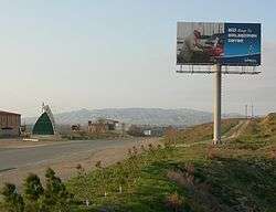 Road from Shirvan reaching Hajigabul Rayon. Hacıqabul city (or Qazıməmməd) in the background
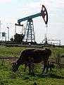 Onshore oil in the vicinity of Hacigabul
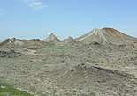 Haciqabul mud volcanoes
 Pirsaat valley
See also
References
- ↑ "Şəhərlərarası telefon kodları". Aztelekom MMC. Aztelekom İB. Retrieved 19 August 2015. (in Azerbaijani)
- ↑ "History of Azerbaijan" (PDF).
- ↑ "Hacıqabul rayonunun tarixi" [History of Hajigabul district]. haciqabul-ih.gov.az. Retrieved 2018-08-29.
- ↑ "Hajigabul district". Official webpage of Azerbaijan National Library (in Azerbaijani).
- ↑ "Library branch#1 of Hajigabul region". cls.az (in Azerbaijani). Retrieved 2018-08-30.
- ↑ "Villages of Hajigabul".
- ↑ "Political division, population size and structure: Economic and administrative regions and towns- Population by sex, towns and regions, urban settlements of the Republic of Azerbaijan at the beginning of 2018".
- ↑ "Political division, population size and structure: Economic and administrative regions and towns - Population by towns and regions of the Republic of Azerbaijan".
- ↑ "Information on the administrative-territorial unit : Hajygabul".
Coordinates: 40°02′17″N 48°56′13″E / 40.037999°N 48.937038°E