Masally District
| Masallı | |
|---|---|
| Rayon | |
.svg.png) Map of Azerbaijan showing Masally Rayon | |
| Coordinates: 39°02′N 48°39′E / 39.033°N 48.650°ECoordinates: 39°02′N 48°39′E / 39.033°N 48.650°E | |
| Country |
|
| Area | |
| • Total | 721 km2 (278 sq mi) |
| Population (2018) | |
| • Total | 223,800 |
| • Density | 311/km2 (810/sq mi) |
| Time zone | UTC+4 (GMT+4) |
| Postal code | AZ4400 |
| Telephone code | (+994) 25[1] |
| Website | masalli-ih.gov.az |

Masally (Masallı) is the administrative area in the south of Azerbaijan.
Geography
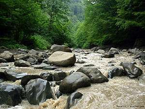
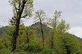
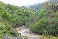
This territory borders on Lankaran, Lerik, Yardimli, Jalilabad, Neftchala districts. In the east, the district is washed by the Caspian Sea, and in the west it approaches Talish mountains, Burovar ridge. Height of the territory reaches 917 metres (3,009 ft). There are mineral and geothermal springs in Masally.[2] Average temperature is 2.1 °C (35.8 °F) in January, and 24.6 °C (76.3 °F) in July. The amount of annual precipitation is 600–800 millimetres (24–31 in). Vilash is the largest river of the district. There are broad-leaved forests of Girkan type-chestnut-leaved oak, hornbeam, beech, Persian ironwood tree, Girkan boxwood, Caucasian persimmon, medlar and others in the mountainous part of the district. Total area of the district's forests equals 16,870 hectares (41,700 acres). There are 107 villages in Masally.
History
Masally rayon was originated in 1930. Formerly, the territory of the district was the part of Arkevan area of Lankaran rayon. Before that, the territory of the district belonged to ancient Manna and Atropatena states. It was included into Talish khanate in the middle of XVIII century.[3]
State political system
The head of Masally rayon is chief executive. Chief executives:
- Safarov Azer Fattah oglu-till September 30, 2004
- Aliyev Ogtay Jalil oglu-from September 30, 2004 to September 29, 2006
- Agayev Gazanfar Arif oglu-since September 30, 2006[4]
- Huseynov Rafil İsrafil oglu-since April 14, 2012
Administrative structure
The center of the district is the city of Masally. Average population density is 159 people per km². Boradigah township, Badalan, Arkevan, Banbashi, Gizilagaj, Teze Alvadi, Chakhirli villages are the other largest population aggregates.
Population
The number of populations in Masally district was 221,5 thousand people and the density was 308/1 km2 for January 1, 2017. At the beginning of 2018, total number of people was 223,8 thousand, which 113,5 thousand of them were men and 110,3 thousand of them were women. The number of people who live in the urban areas of Masally district was 50,8 thousand, while 173,0 thousand people lived in rural areas.[5]
| Total | including: | Urban places | including: | Rural places | including: | |||
| men | women | men | women | men | women | |||
| 223.8 | 113.5 | 110.3 | 50.8 | 26.1 | 24.7 | 173.0 | 87.4 | 85.6 |
Territory
Total area of the district is 72097 ha. 22783 ha (31,6 %) of the territory belongs to the state. 16663 ha (73,1 %) of this area is covered with forests, which Forest Agriculture department owns 15960 ha, and the rest 703 ha is for domestic economy. 440 ha (1,9 %) area is included to water fund and 4609 ha (20,02 %) area belongs to the state reserve fund.[6]
Municipality owns 18738 ha (26,0 %) of the area. 560 ha of this territory is for the perspective development of municipality bodies and 1393 ha of area belongs to the reserve fund of the municipality.[6]
30576 ha (42,4 %) of the area is private property. 26911 ha (88 %) of the territory is privatized and 3665 ha (12 %) belong to the local people.[6]
Economy of district
2,0 million manat were granted to the executive of Masally District for the acceleration of the socio-economic development in the region by the decree of the president dated on 15 March 2012.[7]
Agriculture, construction, industry, transportation, and telecommunication are the cores of economy in Masally district.[8]
Agriculture
| 2010 | 2012 | 2013 | 2014 | 2015 | 2016 | |
| Total area of agricultural crops (ha) | ||||||
| Cereal corps | 11092 | 11790 | 10624 | 11906 | 12432 | 12124 |
| including wheat | 8395 | 8809 | 7604 | 8166 | 8144 | 8141 |
| Tobacco | - | - | - | - | - | 14 |
| Sunflower | 143 | 90 | 90 | 70 | 67 | 62 |
| Potato | 2118 | 2276 | 1477 | 1460 | 1282 | 1044 |
| Vegetable | 3070 | 2798 | 2805 | 2547 | 2542 | 2543 |
| Garden plants | 635 | 577 | 586 | 519 | 515 | 493 |
| Fruit and berry | 443 | 471 | 483 | 492 | 507 | 537 |
| Grape | 21 | 21 | 21 | 21 | 24 | 25 |
| Tea | 5 | 5 | 5 | 22 | 40 | 43 |
| Production of main agricultural products (ton) | ||||||
| Cereal corps | 16059 | 26968 | 24569 | 28163 | 30116 | 30428 |
| including wheat | 10692 | 20385 | 17895 | 19307 | 19871 | 21015 |
| Tobacco | - | - | - | - | - | 10 |
| Sunflower | 229 | 171 | 163 | 123 | 121 | 110 |
| Potato | 28257 | 30482 | 32174 | 18103 | 19219 | 15382 |
| Vegetable | 77281 | 76555 | 70299 | 61987 | 62261 | 63113 |
| Garden plants | 7578 | 7191 | 6903 | 6235 | 6403 | 6560 |
| Fruit and berry | 2139 | 2527 | 2355 | 2339 | 2347 | 2343 |
| Grape | 736 | 875 | 882 | 948 | 953 | 1115 |
| Tea | - | - | - | 15 | 3 | 3 |
| Productivity of agricultural products (centner/ha) | ||||||
| Cereal corps | 14.5 | 22.9 | 23.1 | 23.7 | 24.2 | 25.1 |
| including wheat | 12.7 | 23.1 | 23.5 | 23.6 | 24.4 | 25.8 |
| Tobacco | - | - | - | - | - | 7.0 |
| Sunflower | 16.3 | 19.4 | 18.5 | 18.2 | 18.8 | 18.3 |
| Potato | 133 | 134 | 218 | 124 | 150 | 147 |
| Vegetable | 244 | 270 | 245 | 235 | 244 | 247 |
| Garden plants | 119 | 125 | 118 | 120 | 124 | 133 |
| Fruit and berry | 61.5 | 69.9 | 60.4 | 58.9 | 56.5 | 52.9 |
| Grape | 92.9 | 76.8 | 80.0 | 80.0 | 80.0 | 91.4 |
| Tea | - | - | - | 30.0 | 6.0 | 6.0 |
| Number of cattle | ||||||
| Large cattle | 69338 | 73060 | 74088 | 73007 | 73145 | 73217 |
| including cow and buffalo | 34943 | 36308 | 36619 | 36488 | 36448 | 36495 |
| Sheep and goats | 75678 | 79912 | 83000 | 82451 | 84769 | 84942 |
| Birds | 526474 | 496009 | 501041 | 489812 | 495485 | 509510 |
| Bee families | 3450 | 3714 | 3833 | 3949 | 4102 | 4325 |
| Production of cattle products (ton) | ||||||
| Meat | 3219 | 3226 | 3231 | 3264 | 3299 | 3327 |
| Milk | 42223 | 45289 | 48575 | 48960 | 49018 | 49872 |
| Eggs (in thousand) | 51578 | 52440 | 55200 | 55890 | 56264 | 56666 |
| Wool (in physical weight) | 98 | 99 | 99 | 99 | 99 | 99 |
Construction
| 2010 | 2012 | 2013 | 2014 | 2015 | 2016 | ||
| Given into usage: | |||||||
| Main funds (thousand manat) | 9898.0 | 30545.5 | 30428.8 | 15022.7 | 14360.7 | 46614.5 | |
| Houses, total area (thousand square meters) | 18.5 | 16.4 | 20.3 | 20.3 | 24.9 | 21.0 | |
| of which private houses | 13.9 | 16.4 | 20.3 | 20.2 | 24.9 | 21.0 | |
| Investments in main capital (thousand manat) | 17948.0 | 24883.7 | 28287.9 | 65576.8 | 86206.7 | 111888.6 | |
| including: | |||||||
| construction works | 17085.6 | 23452.2 | 26654.2 | 62268.2 | 81246.9 | 100539.3 | |
| Number of construction companies | 3 | 6 | 7 | 5 | 5 | 3 | |
Industry
In January-December of 2015, there was 37366 thousand manat worth of goods and service production in the Masally industry. It is more 4,6 % more than the previous year. 85,1 percent of the total industrial production was goods and 14,9 percent was services.[6]
Transportation
In 2015, cargo transportation by automobiles was 2368 thousand ton. It is 113 thousand ton more than the previous year. Transportation of passengers was 13324 thousand persons, which is 813 thousand people more than the previous years. The total worth of transportation was 10832,4 thousand manat in 2015.[6]
Telecommunication
In 2015, the total worth of telecommunication services was 1375 thousand manat. It is 5.4 % more than the previous year.[6]
Museums
Museum of History and Local Lore
The construction of the museum stated in 2014 and completed in 2016. The president Ilham Aliyev attended the opening of the museum. The museum has an exhibition hall, administrative room, ideological center, fund, and drawing gallery.[9]
Museum of History and Regional Studies
The museum has more than 7000 exhibits, which illustrates the history of Masally from Eneolithic period to 20th century. Exhibits include sculptures, carving, drawings, clothing, photos, arts, crafts, and documents.[10]
Photos


References
- ↑ "Şəhərlərarası telefon kodları". Aztelekom MMC. Aztelekom İB. Retrieved 19 August 2015. (in Azerbaijani)
- ↑ "Masally Travel Guide". world66.com. April 28, 2006. Retrieved 2017-10-06.
- ↑ "Masallı Regional Mədəniyyət İdarəsi". masalli.mctgov.az. Retrieved 2018-09-17.
- ↑ "Президент Азербайджана усилил исполнительную власть в Масаллинском районе". 29 September 2006.
- ↑ "Population | The State Statistical Committee of the Republic of Azerbaijan". The State Statistical Committee of the Republic of Azerbaijan. Retrieved 2018-09-17.
- 1 2 3 4 5 6 "Rayon haqqında - MASALLI RAYON İcra Hakimiyyəti". www.masalli-ih.gov.az. Retrieved 2018-09-17.
- ↑ Economy, The Republic of Azerbaijan Ministry of (2012-09-27). "Masallı rayonunun sosial-iqtisadi inkişafının daha da sürətləndirilməsinə dair əlavə tədbirlər haqqında - The Republic of Azerbaijan Ministry of Economy". www.economy.gov.az. Retrieved 2018-09-18.
- 1 2 3 "Azərbaycanın regionları | The State Statistical Committee of the Republic of Azerbaijan". The State Statistical Committee of the Republic of Azerbaijan. Retrieved 2018-09-18.
- ↑ "Official web-site of President of Azerbaijan Republic - NEWS » Events". en.president.az. Retrieved 2018-09-25.
- ↑ "MUSEUM OF HISTORY AND REGIONAL STUDIES/MASALLI". azerbaijan.travel. Retrieved 2018-09-25.