Saatly District
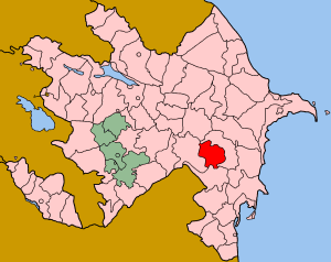
Saatly (Azerbaijani: Saatlı) is an administrative district (rayon) in Azerbaijan. It was established in 1943 and has a current population of 87,000. The district's headquarters are in the city of Saatlı.
General information
The ethnonology of “Saatly” was established in the province called Cukhur Sedd in the bank of Araz River at late 14th century. Historically Saatlis settled in the lower flow of Arpachay river. Beginning from 1430s, Saatlis began to re-settle in the neighboring areas. One part of them was settled in Kazakh region. However, some of them came to Karabakh between 1795 and 1798. The name of the tribe comes from people living in Chukhur Saad or, it is an ethnic name of Saadli Tribe who are Azerbaijani Turks historically settled in Agridag. The district is also home to a large Meskhetian Turkish minority.
Several findings relating to ancient settlements in Saatli were founded. Archeological monuments as well as pottery materials of II - III millenials B.C were excavated in villages of Azadkand, Fetelikand, Jafarkhan, Varkhankand and Alisoltanli.
Saatly region was formed during war period- 1941-1945. During those year, 1600 people were sent to the frontline. 533 people died in war. In 1949 part of the Azerbaijanis expelled from Armenian SSR residents of Jalilabad region in 1953, Akhiska Turks from Middle Asia in 1958-59 and 1989 and part of the people who became refugees as a result of Armenia's occupation policy in 1988-89 were settled in Saatly region.
In the war which began with Armenian aggression against Azerbaijan, youth from Saatly region also fought heroically. Saatly gave 116 martyrs in the fight for Azerbaijan's sovereignty.
Like other regions of Azerbaijan, the region began to revive and flourish its the social-economic and cultural-political state in every field beginning from 1970.
Saatly had 19 school buildings, central hospital for 390 people, cultural center of 450 places, 11 medical point in villages, music school, kindergarten for 450 children, two five-storey buildings with 35 apartments, two storey mall, other administrative buildings, cotton-cleaning and milk plant, bread making plant as well as other industrial, transportation and service institutions were created in the region during 1970s-80s.
Geography
The region is situated in low-land and 28 meters lower above the sea level. The region has dry summer with semi arid and dry climate. Average temperature is 1.4 °C in January and 26,2 °C in summer. The annual precipitation is 300 mm.
Saatly is mainly agricultural region. Cotton planting, farming and vegetable production are main agriculture in the region.
Gallery of Saatly
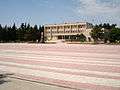 Saatly City Hall
See also
.svg.png)
Coordinates: 39°55′51″N 48°22′10″E / 39.93083°N 48.36944°E