Grundarfjörður
| Grundarfjarðarbær | |
|---|---|
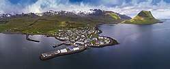 Skyline of Grundarfjarðarbær | |
 Coat of arms of Grundarfjarðarbær | |
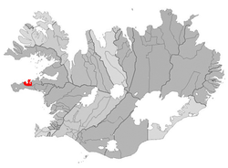 Location of Grundarfjarðarbær | |
 Grundarfjarðarbær | |
| Region | Western Region |
| Constituency | Northwest Constituency |
| Mayor | Þorsteinn Steinsson |
| Area | 148 km2 (57 sq mi) |
| Population | 872 |
| Density | 5.89/km2 (15.3/sq mi) |
| Municipal number | 3709 |
| Postal code(s) | 350 |
| Website |
grundarfjordur |
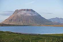
Grundarfjörður is a small town, situated in the north of the Snæfellsnes peninsula in the west of Iceland. It is situated between a mountain range and the sea. The nearby mountain Kirkjufell forms a small peninsula.
Overview
The town received the right to do commerce in 1786. Around 1800, French merchants came to Iceland and lived in Grundarfjörður, where they constructed a church and a hospital of their own. The town has become rich through the fishing industry, and this wealth shows in the style of the original, luxurious houses being built.
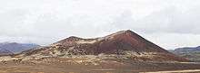
The road to nearby Stykkishólmur crosses a big lava field, called Berserkjahraun. The name of the lava field comes from the Eyrbyggja saga, according to which two Berserkers were slain here by their master, because one of them fell in love with his master's daughter.
Twin towns and cities

See also
References
External links
