Húnaþing vestra
| Húnaþing vestra | |
|---|---|
 Skyline of Húnaþing vestra | |
 Coat of arms of Húnaþing vestra | |
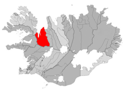 Location of Húnaþing vestra | |
 Húnaþing vestra | |
| Region | Northwestern Region |
| Constituency | Northwest Constituency |
| Manager | Guðný Hrund Karlsdóttir |
| Area | 3,019 km2 (1,166 sq mi) |
| Population | 1,173 |
| Density | 0.39/km2 (1.0/sq mi) |
| Municipal number | 5508 |
| Postal code(s) | 500, 530, 531 |
| Website |
hunathing |
Húnaþing vestra is a municipality located in northern Iceland by Húnaflói gulf. It was founded on 7 June 1998 by the merging of all 7 of the old rural municipalities of Vestur-Húnavatnssýsla. They were: Staðarhreppur, Fremri-Torfustaðahreppur, Ytri-Torfustaðahreppur, Kirkjuhvammshreppur, Hvammstangahreppur, Þverárhreppur and Þorkelshólshreppur. On the 1 January 2012 the municipality was merged with the county of Bæjarhreppur but kept the name Húnaþing vestra.
Húnaþing vestra consists of the three fjords Hrútafjörður og Miðfjörður, and Húnafjörður. Between are the peninsulas of Heggstaðanes and Vatnsnes. Its major settlement is Hvammstangi, but it also has the villages of Laugabakki, Reykir and Borðeyri.
References
External links
- Official website (in Icelandic)
This article is issued from
Wikipedia.
The text is licensed under Creative Commons - Attribution - Sharealike.
Additional terms may apply for the media files.