Húsavík
| Húsavík | |
|---|---|
| Town | |
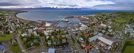 Aerial panorama of the town and the harbour | |
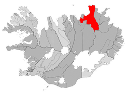 Location of the Municipality of Norðurþing | |
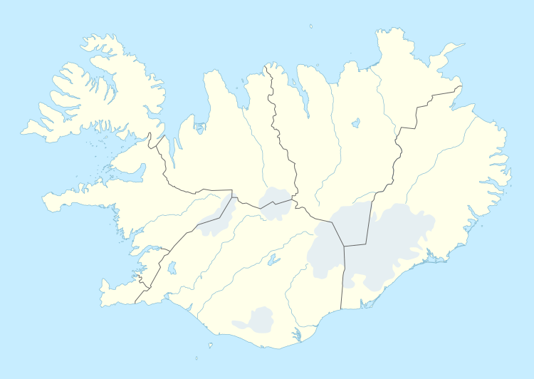 Húsavík Location in Iceland | |
| Coordinates: 66°03′N 17°19′W / 66.050°N 17.317°WCoordinates: 66°03′N 17°19′W / 66.050°N 17.317°W | |
| Country | Iceland |
| Constituency | Northeast Constituency |
| Region | Northeastern Region |
| Municipality | Norðurþing |
| Government | |
| • Mayor | Kristján Þór Magnússon |
| Population (2016) | |
| • Total | 2,182 |
| Time zone | UTC+0 (GMT) |
| Post Code | 640, 645 |
| Website | Official website |
Húsavík is a town in Norðurþing municipality on the north coast of Iceland on the shores of Skjálfandi bay with 2,182 inhabitants. The most famous landmark of the town is the wooden church Húsavíkurkirkja, built in 1907. Húsavík is served by Húsavík Airport.
Overview
Income is derived from tourism and fishing, as well as retail and small industry. Until recently, Húsavík was the export harbour for silica that was extracted from nearby lake Mývatn.
According to the Landnámabók ("Book of Settlement"), Húsavík was the first place in Iceland to be settled by a Norse man. The Swedish Viking Garðar Svavarsson stayed there for one winter around 870 A.D. When he left the island in spring of 870, after a winter's stay, he left behind a man named Nattfari and two slaves, a man and a woman, and they established a farm here.[1] The name of the town means "bay of houses", probably referring to Garðar's homestead, which may have been the only houses then in Iceland.
Tourism
Húsavík has become a centre of whale watching in Iceland due to whales of different species that frequently enter the bay. The Húsavík Whale Museum is located in the downtown by the harbour. [2]
In town there is also a civic museum about culture and biology. Among other things, it shows a stuffed polar bear (arrived in Grimsey in 1969) and ancient boats.
Húsavík is also home to The Exploration Museum, a museum about the history of human exploration. A monument honoring the Apollo astronauts that trained around Húsavík during the 1960s is located outside the museum.[3]
The region of Mývatn, with its interesting geology and diverse animal life, is nearby. Jökulsárgljúfur National Park with the horseshoe-shaped canyon Ásbyrgi and the waterfalls Dettifoss, Hafragilsfoss and Selfoss is also not far from the town.
Sports
ÍF Völsungur is the local football club. They last played in Iceland's top tier in the 1988 season.[4]
International relations
Twin towns – Sister cities
- Karlskoga, Sweden
- Fredrikstad, Norway
- Riihimäki, Finland
- Aalborg, Denmark[5]
- Qeqertarsuaq, Greenland
- Fuglafjørður, Faroe Islands
- Eastport, Maine, USA[6]
Climate
| Climate data for Húsavík (2000-2017) | |||||||||||||
|---|---|---|---|---|---|---|---|---|---|---|---|---|---|
| Month | Jan | Feb | Mar | Apr | May | Jun | Jul | Aug | Sep | Oct | Nov | Dec | Year |
| Record high °C (°F) | 15.3 (59.5) |
12.2 (54) |
17.7 (63.9) |
23.1 (73.6) |
25.3 (77.5) |
26.3 (79.3) |
28.8 (83.8) |
24.6 (76.3) |
26.2 (79.2) |
19.0 (66.2) |
15.5 (59.9) |
16.2 (61.2) |
28.8 (83.8) |
| Average high °C (°F) | 1.8 (35.2) |
1.9 (35.4) |
1.9 (35.4) |
5.7 (42.3) |
9.0 (48.2) |
12.8 (55) |
15.2 (59.4) |
13.5 (56.3) |
10.0 (50) |
6.4 (43.5) |
3.1 (37.6) |
2.0 (35.6) |
6.9 (44.5) |
| Daily mean °C (°F) | 0.9 (33.6) |
0.1 (32.2) |
0.3 (32.5) |
2.9 (37.2) |
5.1 (41.2) |
9.0 (48.2) |
12.1 (53.8) |
10.8 (51.4) |
8.7 (47.7) |
4.2 (39.6) |
3.9 (39) |
−0.4 (31.3) |
4.8 (40.6) |
| Average low °C (°F) | −4.2 (24.4) |
−3.7 (25.3) |
−4.0 (24.8) |
−1.6 (29.1) |
1.9 (35.4) |
5.4 (41.7) |
7.2 (45) |
6.9 (44.4) |
3.8 (38.8) |
1.0 (33.8) |
−2.3 (27.9) |
−4.0 (24.8) |
0.5 (32.9) |
| Record low °C (°F) | −18.0 (−0.4) |
−16.5 (2.3) |
−21.2 (−6.2) |
−17.4 (0.7) |
−9.8 (14.4) |
−3.5 (25.7) |
0.5 (32.9) |
0.3 (32.5) |
−5.8 (21.6) |
−10.2 (13.6) |
−15.0 (5) |
−17.5 (0.5) |
−21.2 (−6.2) |
| Average precipitation mm (inches) | 78.6 (3.094) |
60.2 (2.37) |
62.7 (2.469) |
50.4 (1.984) |
37.2 (1.465) |
42.0 (1.654) |
65.3 (2.571) |
69.0 (2.717) |
90.1 (3.547) |
101.4 (3.992) |
87.3 (3.437) |
77.1 (3.035) |
821.3 (32.335) |
| Source: Icelandic Met Office[7] | |||||||||||||
Daylight hours
Húsavík experiences midnight sun from 11 June until 29 June.[8]
Although Húsavík doesn't experience polar night in December solstice, the shortest daylight hours in Húsavík are 2 hours 45 minutes, from 11:45 UTC until 14:30 UTC on 21 December.[9]
Gallery
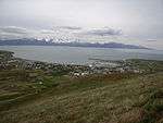 View from the mountain
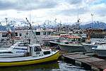 Húsavík harbor (1)
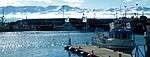 Húsavík harbor (2)
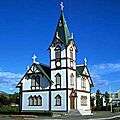 Church of Húsavík
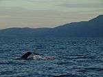 Whales in Skjalfandi near Húsavík
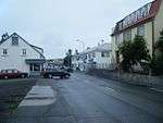 A street in Húsavík
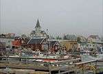 Húsavík - town, harbour and church
See also
References
- ↑ Guðni Th. Jóhannesson (9 January 2013). The History of Iceland. ABC-CLIO. pp. 6–7, 19–20. ISBN 978-0-313-37621-4.
- ↑ "Whale museum homepage". Archived from the original on 6 July 2010.
- ↑ Hnefill, Örlygur (12 August 2015). "Apollo astronauts revisit training area in Iceland and explore a new lava flow". The Exploration Museum.
- ↑ Iceland 1988 – RSSSF
- ↑ "Aalborg Twin Towns". Europeprize.net. Archived from the original on 7 September 2013. Retrieved 19 August 2013.
- ↑ "Nordurthing homepage" (in Icelandic). nordurthing.is.
- ↑ "Climatological Data for Húsavík". Icelandic Meteorological Office. Retrieved 23 September 2016.
- ↑ http://jan.moesen.nu/daylight-calculator/?location=H%C3%BAsav%C3%ADk%2C+Iceland&latitude=66.0449706&longitude=-17.338344300000017
- ↑ http://jan.moesen.nu/daylight-calculator/?location=H%C3%BAsav%C3%ADk%2C+Iceland&latitude=66.0449706&longitude=-17.338344300000017
External links
| Wikimedia Commons has media related to Húsavík. |
| Wikivoyage has a travel guide for Húsavík. |
- Official tourist information website
- Official website (in English) (in Icelandic)
- Whalewatching and information about whales
- Húsavík whale watching
