Groom Mine
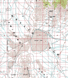 United States Geological Survey map depicting the location of Groom Mine | |
| Location | |
|---|---|
| Lincoln County, Nevada[1] | |
| Coordinates | 37°20′46″N 115°46′09″W / 37.3462°N 115.7692°WCoordinates: 37°20′46″N 115°46′09″W / 37.3462°N 115.7692°W |
| Production | |
| Products | Silver[2] |
| Type | Open-pit & underground[3] |
| Greatest depth | 210 feet[4] |
| History | |
| Opened | 1875 |
| Active | 1875–1954 |
| Closed | 2015[5] |
| Owner | |
| Company | United States Government[5] |
| Year of acquisition | 2015[5] |
Groom Mine was a mine in Lincoln County, Nevada, which first opened in the 1870s, and ceased operations in 1954.[6] During World War II the mine began to be surrounded by military activity.[7] In the 1950s the mine was exposed to fallout from nuclear testing on the Nevada Test Site.[7] It was taken by the United States Government via eminent domain via a court order in 2015.[5]
Background
Prior to European exploration of the area, the Southern Paiute lived in the region.[8] Following discovery of minerals in the Comstock Lode, prospecting of other areas in Nevada began.[9] Mining in the area began in the late 1860s, after minerals were first discovered in the Groom Range in 1864.[10] The rocks in the range date back to the Paleozoic era, and covered by Tertiary rocks on its east and north sides.[11] A mining district to organize claims, called the Groom District, was formed in 1869.[9] In 1871, the area was documented in the Wheeler Survey.[8] Most mining in the area was finished by 1874, primarily mining silver chloride ores.[10] By 1956, official recordings of products of the district shows that the largest mineral harvested was lead, as well as over 145,000 troy ounces (4,500 kg) of silver, and about 45 troy ounces (1.4 kg) of gold.[12]
History
Mining
A patent for the Groom mine was issued in 1872, and in 1885 the Sheahan family acquired the property.[10][13] The mine was three days travel from Indian Springs, and was 5,250 above sea level, making it very isolated.[8] As documented in 1998 by the Nevada Bureau of Mines and Geology, the property claim is officially named "Conception".[14] In addition to the Conception claim, other claims were made, and held by the Sheahan family, within the Groom District.[8] From 1915 until 1917, the mine was leased to Tom McCormick, who worked the mine.[8] In September 1917, a miner, who had immigrated from Austria-Hungary, of the Groom Mining Company died at the mine.[15] In the mid to late 1910s the mine produced silver worth about a quarter of a million dollars.[16] By the end of that decade, shipping the mined products became difficult, with the closing of the Las Vegas and Tonopah Railroad;[17] this caused the mine to become temporarily idle.[18] By 1922, the mine had two shafts, the longest being 200 feet in depth.[19]
Road to the mine coming from the west were closed due to military activities, leading to the Sheahan family, as well as Lincoln County, to build a road from the east.[7] In 1942, a mill began to be constructed at the mine which utilized a gravity and flotation method.[8] By 1951, four people were living at the mine, and a concentration mill had been built.[20] Ore, which lead and silver was extracted from, mined from Groom Mine was found to contain cerussite and galena.[1] During the 1950s, mining operations paused due to nearby nuclear tests.[21] In 1954, production from the mine ended.[22]
The mine product until 1956 totaled almost a million dollars in several minerals including copper, silver, and gold;[10] In 1977, the United States Bureau of Mines valued the output of Groom mine products at $3.75 million.[4] It was the most productive mine in the Groom Mining District;[10] it had been worked on by three generations of the Sheahan family.[8] Other minerals that could be within the claim area, based on panning samples near Groom Mine, include antimony, barium, lead, mercury, and zinc.[23] By 1959, the Sheahan family moved away from the mine, but visited their property regularly.[7] In 1984, the Sheahan Family who continued to own the Groom Mine, also had the legal rights to most of the 22 other patented mining claims near the Groom Mine.[24] A 1990 Bureau of Land Management stated that due to restricted access to the mine it would lead to "potential loss of income through inability to expand or further develop the claims."[25] Until Fall 2015, the Sheahan family would periodically blast for minerals at the mine;[6] by this time the Sheahan family owned the mine for 130 years.[26]
Military interaction
In 1941, the Groom Mine was visited by individuals surveying the area for a gunnery and bombing range to be used during World War II, staying at the mine with the Sheahan family during the surveying of the area.[7] The outhouse and bunkhouse at the mine were strafed during World War II by aircraft utilizing the Las Vegas Bombing and Gunnery Range.[8] Beginning in the 1950s, Groom Mine began to begin to be impacted by nuclear tests occurring in the Nevada Test Site.[7] In 1951, the Atomic Energy Commission, informed the Sheahan family of the planned detonations, setting up instrumentation at the mine.[21][27] The instrumentation was monitored by an employee of the United States Public Health Service, who at the time lived at the mine along with the Sheahan Family.[28] The first of the nuclear tests was the Operation Tumbler–Snapper Easy Test, which led to the mine being evacuated due to its proximity to the detonation.[29] It caused some structural damage, including breaking the front door of the Sheahan's home.[21] Further away, fallout impacted nearby Tempiute.[29] Returning to the mine had to be done using a different route than normal which was too radioactive to travel on.[30] The following Fox test, in late May 1952, did lead to fallout falling on the mine.[29] However, it was the view of the Atomic Energy Commission that the nuclear detonations "had not subjected Groom Mine personnel to any real danger from fallout."[31]
By May 1952, the majority of the Sheahan family evacuated the mine, moving to Las Vegas.[21] In July 1952, a member of the Sheahan family who had been directly exposed to fallout, Martha, was diagnosed as having cancer.[8] Following Operation Upshot–Knothole, the Sheahan family attempted to sell their claim to the Atomic Energy Commission, but was refused fearing it would set a precedent; instead the family received a total of $1,100 for losses and damages resulting from the Operation Tumbler-Snapper tests.[32] Following adverse environmental impact observed by the two remaining Sheahan family members at the mine caused by Upshot-Knothole Harry, the Atomic Energy Commission said that the blasts were designed to have winds from the testing to head towards Groom, rather than towards Las Vegas.[21] In 1956, the Sheahan family, as well as others filed lawsuits, due to damages caused by nuclear testing, against the Atomic Energy Commission.[33] In 1959, the lawsuit was withdrawn due to the Sheahan family running out of funds to continue the lawsuit.[34]
During 1953, the property was strafed, and during the summer a bomb destroyed the mine's mill;[35] no specific claim was made by the Sheahan family against the United States Air force for the event.[36] In 1954, the mining buildings were strafed by aircraft utilizing the Nellis Air Force Gunnery and Bombing Range.[21] The property which the mine is located on has a view of an airfield known as Area 51.[5][7] In the 1970s and 1980s armed personnel came onto the mine property when the Sheahan family came onto their property, sometimes locking them into their own buildings.[7]
In 1984 the United States Air Force seized lands around Groom Mine;[24] this had the result of restricting access to the mine for the Sheahan family.[35][37] Some of the Sheahan family were issued security clearances after 1984.[21] In 1986, the 1953 mill destruction event was entered into the record of a subcommittee of the United States House Committee on Natural Resources.[38] In 1987, the position of the United States Air Force was "We don't want to go in and tell them to get the hell out".[39] In 1989, although within the Nevada Test and Training Range, the United States Air Force was allowing access to claimants to their claims within the Groom Mining District, including Groom Mine.[40]
Government ownership
Beginning in late 2014, the United States Department of Defense attempted to purchase the property from the Sheahan family, offering $1.5 million at first.[6] By August 2015, the United States Air Force had upped the offer to $5.2 million; the offers continued to be turned down.[7][41] In August 2015, a government press released described the mine as a "safety and security risk", even though the Sheahan family had not disclosed any activities of the Groom Lake facility.[42] In September 2015, the commander of the Nevada Test and Training Range stated that the existence of the mine within the range led to "tremendous expense" due to "canceling missions when they came out"[34] (i.e. secret operations at the base could not proceed when civilians were present on the Sheahan's property, within easy view of the installation). On 16 September 2015, the property was condemned under eminent domain and given to the United States Government by a court order signed by federal Judge Miranda Du.[5]
It was not determined at the time of transfer of ownership how much the Sheahan family would receive in compensation for the government acquisition of the Groom Mine; the United States Air Force in 2015 estimated the land to be worth $1.5 million.[5] In November 2015, the Sheahan family suggested that the mine be protected as a national historic site;[43] this coincides with a suggestion in a previous 1980s reported produced by the United States Air Force that recommended that the Groom Mining District be nominated to be listed on the National Register of Historic Places.[8] By 2016, the United States Air Force only valued the Groom Mine at under a third of a million dollars;[44] the Sheahan family's legal counsel valued the property as being as high as over $100 million.[45] In 2017, the Sheahan family claimed that they were forced to leave millions of dollars worth of property at Groom Mine, when the government seized the mine;[46] part of the property which was abandoned includes an antique anvil, which was missing when personal property was reviewed in November 2015.[47]
See also
References
- 1 2 Stephen B. Castor; Gregory C. Ferdock (2004). Minerals of Nevada. University of Nevada Press. p. 139. ISBN 978-0-87417-540-0.
- ↑ Geology and Mining Series. University of Nevada. 1904. p. 161.
- ↑ Donald Zona (October 1985). Draft Environmental Impact STatement Groom Mountain Range (PDF) (Report). United States Air Force. p. 3-24. Retrieved 13 March 2018.
- 1 2 John R. Norberg (12 August 1977). Mineral Resources in the Vicinity of the Nellis Air Force Base and the Nellis Bombing and Gunnery Range, Clark, Lincoln, and Nye Counties, Nevada (PDF) (Report). United States Department of the Interior. Retrieved 13 March 2018.
- 1 2 3 4 5 6 7 Meek, Glen (16 September 2015). "Government takes family's land near Area 51". KLAS-TV. Las Vegas. Retrieved 10 March 2018.
- 1 2 3 Craft, Andrew (13 December 2016). "Family fights government in land dispute near Area 51". Fox News. New York City. Retrieved 13 March 2018.
- 1 2 3 4 5 6 7 8 9 Rogoway, Tyler (9 November 2015). "The Unlikely Struggle Of The Family Whose Neighbor Is Area 51". Foxtrot Alpha. Jalopnik. Retrieved 8 March 2018.
- 1 2 3 4 5 6 7 8 9 10 Paine, Gary (Spring 1996). "A Mine, the Military, and a Dry Lake: National Security and the Groom District, Lincoln County, Nevada" (PDF). Nevada Historical Society Quarterly. 39 (1): 20–42. Retrieved 14 March 2018.
- 1 2 OF1998-01: Mineral and energy resource assessment of the Nellis Air Force Range. NV Bureau of Mines & Geology. p. 7. GGKEY:0JR4J3LY7P1.
- 1 2 3 4 5 United States. Bureau of Land Management. Las Vegas District (1989). Draft Resource Plan and Environmental Impact Statement for the Nellis Air Force Range Planning Area. The District. p. 162.
- ↑ Nevada Bureau of Mines and Geology; J. V. Tingley (1984). OF1984-01: A Mineral Inventory of the Caliente Resource Area, Caliente District, Lincoln County, Nevada. NV Bureau of Mines & Geology. p. 28. GGKEY:7TSA0GECEY0.
- ↑ OF1998-01: Mineral and energy resource assessment of the Nellis Air Force Range. NV Bureau of Mines & Geology. p. 136. GGKEY:0JR4J3LY7P1.
- ↑ Jack G. Quade (1986). OF1986-09: Mineral Inventory and Geochemical Survey, Groom Mountain Range, Lincoln County, Nevada. NV Bureau of Mines & Geology. pp. 8–. GGKEY:XT9W6WCT82L.
- ↑ OF1998-01: Mineral and energy resource assessment of the Nellis Air Force Range. NV Bureau of Mines & Geology. p. 154. GGKEY:0JR4J3LY7P1.
- ↑ Nevada. Legislature (1919). Appendix to Journals of Senate and Assembly ... of the Legislature. pp. 35–36.
- ↑ Geology and Mining Series. University of Nevada. 1904. p. 121.
- ↑ Intermountain Industry and Engineering: Official Publication: Utah Motor Transport Ass'n. The Association. 1920. p. 39.
- ↑ Intermountain Industry and Engineering: Official Publication: Utah Motor Transport Ass'n. The Association. 1920. p. 34.
- ↑ The Mines Handbook: An Enlargement of the Copper Hand Book; a Manual of the Mining Industry of North America. Stevens Copper Handbook Company. 1922. p. 1219.
- ↑ Rebecca Solnit (6 June 2014). Savage Dreams: A Journey into the Hidden Wars of the American West. University of California Press. p. 34. ISBN 978-0-520-95792-3.
- 1 2 3 4 5 6 7 Phil Patton (31 October 2012). Dreamland: Travels Inside the Secret World of Roswell and Area 51. Random House Publishing Group. pp. 93–97. ISBN 978-0-307-82860-6.
- ↑ O'Neill, Marine (17 September 2015). "US air force threatens to destroy property next door to Area 51 after owners refuse to sell". News Corp Australia. Retrieved 13 March 2018.
- ↑ United States. Bureau of Land Management. Las Vegas District (1989). Draft Resource Plan and Environmental Impact Statement for the Nellis Air Force Range Planning Area. The District. p. 165.
- 1 2 Chrystal, Chris (6 August 1984). "Air Force: 'We had no legal authority'". United Press International. Retrieved 8 March 2018.
- ↑ Spang, Edward F. (1990). Caliente Resource Area, Nellis Air Force Range Resource Plan: Environmental Impact Statement. Bureau of Land Management. pp. H–8.
- ↑ Huff, Steve (12 September 2015). "True American Takes Stand Against Mysterious Area 51 Expansion". Maxim. New York City: Biglari Holdings. Retrieved 15 March 2018.
- ↑ Susan Wright (15 August 1998). UFO Headquarters: Investigations On Current Extraterrestrial Activity In Area 51. St. Martin's Press. p. 7. ISBN 978-0-312-20781-6.
- ↑ Sarah Alisabeth Fox (November 2014). Downwind: A People's History of the Nuclear West. U of Nebraska Press. pp. 59–60. ISBN 978-0-8032-5537-1.
- 1 2 3 Leisl Carr Childers (9 October 2015). The Size of the Risk: Histories of Multiple Use in the Great Basin. University of Oklahoma Press. pp. 79–80. ISBN 978-0-8061-5253-0.
- ↑ Philip L. Fradkin (March 2004). Fallout: An American Nuclear Tragedy. Big Earth Publishing. p. 101. ISBN 978-1-55566-331-5.
- ↑ Leisl Carr Childers (9 October 2015). The Size of the Risk: Histories of Multiple Use in the Great Basin. University of Oklahoma Press. p. 93. ISBN 978-0-8061-5253-0.
- ↑ Leisl Carr Childers (9 October 2015). The Size of the Risk: Histories of Multiple Use in the Great Basin. University of Oklahoma Press. p. 246. ISBN 978-0-8061-5253-0.
- ↑ Leisl Carr Childers (9 October 2015). The Size of the Risk: Histories of Multiple Use in the Great Basin. University of Oklahoma Press. pp. 100–101. ISBN 978-0-8061-5253-0.
- 1 2 Kravarik, Jason; Simon, Dan (12 September 2015). "A battle is on for Area 51 in Nevada, but not the kind you might think". CNN. Atlanta. Retrieved 13 March 2018.
- 1 2 Rebecca Solnit (6 June 2014). Savage Dreams: A Journey into the Hidden Wars of the American West. University of California Press. p. 35. ISBN 978-0-520-95792-3.
- ↑ Groom Mountain Range, Lincoln County, Renewed Withdrawal from Nellis Air Force Range: Environmental Impact Statement. 1986. pp. 3–13.
- ↑ Phil Patton (31 October 2012). Dreamland: Travels Inside the Secret World of Roswell and Area 51. Random House Publishing Group. p. 76. ISBN 978-0-307-82860-6.
- ↑ United States. Congress. House. Committee on Interior and Insular Affairs. Subcommittee on Public Lands and National Parks (1986). Additions to the National Wilderness Preservation System: Hearings Before the Subcommittee on Public Lands of the Committee on Interior and Insular Affairs, House of Representatives, Ninety-ninth Congress, First Session ... U.S. Government Printing Office. p. 215.
- ↑ Rothberg, Daniel (10 September 2015). "Deadline expires for private land near Area 51". Las Vegas Sun. Retrieved 13 March 2018.
- ↑ United States. Bureau of Land Management. Las Vegas District (1989). Draft Resource Plan and Environmental Impact Statement for the Nellis Air Force Range Planning Area. The District. p. 166.
- ↑ Rogers, Keith (31 August 2015). "Family rejects Air Force's $5.2 million bid for land near Area 51". Las Vegas Review Journal. Retrieved 10 March 2018.
- ↑ Ritter, Ken (7 September 2015). "Air Force wants owners to give up Nevada bombing range site". Air Force Times. Vienna, Virginia. The Associated Press. Retrieved 13 March 2018.
- ↑ Meek, Glen (10 November 2015). "Family seeks appraisal of Groom Lake property near Area 51". KLAS-TV. Las Vegas. Retrieved 13 March 2018.
- ↑ Rogers, Keith (2 May 2017). "Family accuses Air Force of lowball price estimate on land it seized near Area 51". Las Vegas Review-Journal. Retrieved 13 March 2018.
- ↑ Rogoway, Tyler (6 December 2016). "Family Says Land Overlooking Area 51 Is Worth $116M—USAF Says $330k". The War Zone. Time Inc. Retrieved 13 March 2018.
- ↑ Rogers, Keith (2 May 2017). "Family fighting land seizure accuses US of 'bullying tactics'". Las Vegas Review-Journal. Retrieved 13 March 2018.
- ↑ Rogoway, Tyler (10 May 2017). "Family Demands To Know How A 200-Pound Antique Anvil Disappeared From Area 51". The Warzone. Time Inc. Retrieved 13 March 2018.
Further reading
- Groom Mining District Records, ID: 99-19. Special Collections, University Libraries: University of Nevada, Reno.
External links
- Official website
- "Groom Mine". Western Mining History. 2017.
Municipalities and communities of Lincoln County, Nevada, United States | ||
|---|---|---|
| Cities | 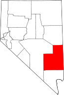 | |
| CDPs | ||
| Other unincorporated communities | ||
| Ghost towns | ||
| Footnotes | ‡This populated place also has portions in an adjacent county or counties | |