Groom Range
| Groom Range | |
|---|---|
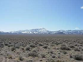 A portion of Groom Range with highest peak in the center. | |
| Highest point | |
| Elevation | 2,819 m (9,249 ft) |
| Geography | |
| Location | Part of the Nevada Test and Training Range |
| Country | United States |
| State | Nevada |
| District | Lincoln County |
| Range coordinates | 37°26′59.837″N 115°44′5.115″W / 37.44995472°N 115.73475417°WCoordinates: 37°26′59.837″N 115°44′5.115″W / 37.44995472°N 115.73475417°W |
| Topo map | USGS Groom Range |

The Groom Range is a mountain range in Lincoln County, Nevada.[1] The range was renamed from Naquinta Mountains or Tequima Range in 1864, after Bob Groom, who discovered minerals in the range.[2] It is located within the Nevada Test and Training Range, north of Groom Dry Lake. The highest point in the Groom Range is 9,249 feet. The Groom Range is situated 26.6 miles north of the dry Groom Lake.
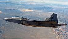
A F-22 is in the foreground, with the Groom Range in the background on the upper right.
See also
References
- 1 2 "Groom Range". Geographic Names Information System. United States Geological Survey. Retrieved 2009-05-04.
- ↑ Phil Patton (31 October 2012). Dreamland: Travels Inside the Secret World of Roswell and Area 51. Random House Publishing Group. pp. 80–81. ISBN 978-0-307-82860-6.
This article is issued from
Wikipedia.
The text is licensed under Creative Commons - Attribution - Sharealike.
Additional terms may apply for the media files.