Greig, New York
| Greig, New York Brantingham | |
|---|---|
| Town | |
 Greig, New York Location within the state of New York | |
| Coordinates: 43°41′50″N 75°18′45″W / 43.69722°N 75.31250°W | |
| Country | United States |
| State | New York |
| County | Lewis |
| Established as Brantingham | 1828 |
| Name changed to Greig | 1832 |
| Area[1] | |
| • Total | 94.36 sq mi (244.40 km2) |
| • Land | 92.99 sq mi (240.85 km2) |
| • Water | 1.37 sq mi (3.55 km2) |
| Elevation | 1,237 ft (377 m) |
| Population (2010) | |
| • Total | 1,199 |
| • Estimate (2016)[2] | 1,206 |
| • Density | 12.97/sq mi (5.01/km2) |
| Time zone | UTC-5 (Eastern (EST)) |
| • Summer (DST) | UTC-4 (EDT) |
| ZIP code | 13345 |
| Area code(s) | 315 |
| FIPS code | 36-049-30796 |
| GNIS feature ID | 979026[3] |
Greig is a town in Lewis County, New York, United States, Named after John Greig,[4] the town was founded in 1828 from land within the boundary of Watson, New York. Originally named Brantingham, the town changed to its present name, February 20, 1832. Brantingham still survives as a hamlet within the boundaries of Greig, as a postal identity and for Brantingham Lake, to the east of town. As of the 2010 Census, the population was 1,199.
Geography
According to the United States Census Bureau, the town has a total area of 94.3 square miles (244 km2), of which 92.9 square miles (241 km2) is land and 1.4 square miles (3.6 km2) (1.51%) is water.
The eastern town line is the border of Herkimer County, and the western town line is defined by the Black River.
The eastern half of the town is inside the Adirondack Park. It is the largest park in the contiguous United States (6.1 million acres), the largest National Historic Landmark, and the largest area protected by any U. S. state. The impetus to protect the land began in 1870 and by 1885, legislation had been passed to protect the land. The park was established in 1892. The park was given state constitutional protection in 1894, so that the state-owned lands within its bounds would be protected forever (forever wild). The part of the Adirondack State Park under government control is referred to as the Adirondack Forest Preserve, which became a National Historic Landmark in 1963.
Demographics
| Historical population | |||
|---|---|---|---|
| Census | Pop. | %± | |
| 1830 | 662 | — | |
| 1840 | 592 | −10.6% | |
| 1850 | 1,074 | 81.4% | |
| 1860 | 1,733 | 61.4% | |
| 1870 | 2,638 | 52.2% | |
| 1880 | 1,570 | −40.5% | |
| 1890 | 1,481 | −5.7% | |
| 1900 | 1,100 | −25.7% | |
| 1910 | 807 | −26.6% | |
| 1920 | 635 | −21.3% | |
| 1930 | 821 | 29.3% | |
| 1940 | 747 | −9.0% | |
| 1950 | 642 | −14.1% | |
| 1960 | 693 | 7.9% | |
| 1970 | 774 | 11.7% | |
| 1980 | 1,115 | 44.1% | |
| 1990 | 1,323 | 18.7% | |
| 2000 | 1,365 | 3.2% | |
| 2010 | 1,199 | −12.2% | |
| Est. 2016 | 1,206 | [2] | 0.6% |
| U.S. Decennial Census[5] | |||
As of the census[6] of 2000, there were 1,365 people, 533 households, and 386 families residing in the town. The population density was 14.7 people per square mile (5.7/km²). There were 1,260 housing units at an average density of 13.6 per square mile (5.2/km²). The racial makeup of the town was 98.90% White, 0.07% Native American, 0.37% Asian, 0.07% Pacific Islander, and 0.59% from two or more races. Hispanic or Latino of any race were 0.59% of the population.
There were 533 households out of which 30.2% had children under the age of 18 living with them, 60.6% were married couples living together, 6.8% had a female householder with no husband present, and 27.4% were non-families. 21.6% of all households were made up of individuals and 9.8% had someone living alone who was 65 years of age or older. The average household size was 2.55 and the average family size was 2.93.
In the town, the population was spread out with 24.8% under the age of 18, 6.0% from 18 to 24, 28.2% from 25 to 44, 26.4% from 45 to 64, and 14.6% who were 65 years of age or older. The median age was 40 years. For every 100 females, there were 99.9 males. For every 100 females age 18 and over, there were 97.7 males.
The median income for a household in the town was $35,179, and the median income for a family was $39,028. Males had a median income of $32,596 versus $22,857 for females. The per capita income for the town was $15,838. About 4.7% of families and 8.9% of the population were below the poverty line, including 4.7% of those under age 18 and 10.8% of those age 65 or over.
Communities and locations in Greig
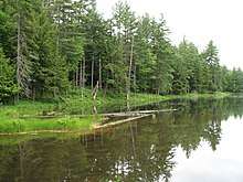
- Brantingham – A hamlet near the center of the town, located inside the Adirondack Park.
- Brantingham Lake – A lake east of Brantingham and its residences.
- Catspaw Lake – A small lake north of Brantingham and its residences.
- Little Pine Lake – A small lake located south of Pine Lake.
- East Pine Pond – A 13 acre pond located east of Pine Lake.
- Glenfield – A hamlet at the western town line, at the Black River.
- Greig – The hamlet of Greig is in the southwestern part of the town.
- Otter Creek – A hamlet in the northwestern part of the town, north of Greig village.
- Pine Lake – A lake located east of Brantingham, near the east town line.
References
- ↑ "2016 U.S. Gazetteer Files". United States Census Bureau. Retrieved Jul 5, 2017.
- 1 2 "Population and Housing Unit Estimates". Retrieved June 9, 2017.
- ↑ U.S. Geological Survey Geographic Names Information System: Greig, New York
- ↑ Gannett, Henry (1905). The Origin of Certain Place Names in the United States. Govt. Print. Off. p. 144.
- ↑ "Census of Population and Housing". Census.gov. Archived from the original on May 12, 2015. Retrieved June 4, 2015.
- ↑ "American FactFinder". United States Census Bureau. Archived from the original on 2013-09-11. Retrieved 2008-01-31.
External links
Coordinates: 43°40′53″N 75°21′17″W / 43.68139°N 75.35472°W
Municipalities and communities of Lewis County, New York, United States | ||
|---|---|---|
| Towns | 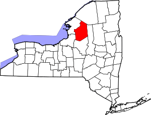 | |
| Villages | ||
| Other hamlets | ||