List of hamlets in Lewis County, New York
This is a list of the hamlets in Lewis County, New York.
References
- ↑ U.S. Geological Survey Geographic Names Information System: Alpina
- ↑ U.S. Geological Survey Geographic Names Information System: Barnes Corners
- ↑ U.S. Geological Survey Geographic Names Information System: Beaver Falls
- ↑ U.S. Geological Survey Geographic Names Information System: Belfort
- ↑ U.S. Geological Survey Geographic Names Information System: Bellwood
- ↑ U.S. Geological Survey Geographic Names Information System: Brantingham
- ↑ U.S. Geological Survey Geographic Names Information System: Briggs Corner
- ↑ U.S. Geological Survey Geographic Names Information System: Bushes Landing
- ↑ U.S. Geological Survey Geographic Names Information System: Clark Corners
- ↑ U.S. Geological Survey Geographic Names Information System: Collinsville
- ↑ U.S. Geological Survey Geographic Names Information System: Crystal Dale
- ↑ U.S. Geological Survey Geographic Names Information System: Dadville
- ↑ U.S. Geological Survey Geographic Names Information System: Deer River
- ↑ U.S. Geological Survey Geographic Names Information System: Denmark
- ↑ U.S. Geological Survey Geographic Names Information System: Diana Center
- ↑ U.S. Geological Survey Geographic Names Information System: East Martinsburg
- ↑ U.S. Geological Survey Geographic Names Information System: Fish Creek
- ↑ U.S. Geological Survey Geographic Names Information System: Forest City
- ↑ U.S. Geological Survey Geographic Names Information System: Fowlersville
- ↑ U.S. Geological Survey Geographic Names Information System: Freeman Mill
- ↑ U.S. Geological Survey Geographic Names Information System: Glendale
- ↑ U.S. Geological Survey Geographic Names Information System: Glenfield
- ↑ U.S. Geological Survey Geographic Names Information System: Goulds Mill
- ↑ U.S. Geological Survey Geographic Names Information System: Greig
- ↑ U.S. Geological Survey Geographic Names Information System: Harrisburg
- ↑ U.S. Geological Survey Geographic Names Information System: High Falls
- ↑ U.S. Geological Survey Geographic Names Information System: Hooker
- ↑ U.S. Geological Survey Geographic Names Information System: Hoseville
- ↑ U.S. Geological Survey Geographic Names Information System: Indian River
- ↑ U.S. Geological Survey Geographic Names Information System: Jerden Falls
- ↑ U.S. Geological Survey Geographic Names Information System: Kimball Mill
- ↑ U.S. Geological Survey Geographic Names Information System: Kirschnerville
- ↑ U.S. Geological Survey Geographic Names Information System: Kosterville
- ↑ U.S. Geological Survey Geographic Names Information System: Lake Bonaparte
- ↑ U.S. Geological Survey Geographic Names Information System: Leisher Mill
- ↑ U.S. Geological Survey Geographic Names Information System: Locust Grove
- ↑ U.S. Geological Survey Geographic Names Information System: Lyonsdale
- ↑ U.S. Geological Survey Geographic Names Information System: Martinsburg
- ↑ U.S. Geological Survey Geographic Names Information System: Michigan Mills
- ↑ U.S. Geological Survey Geographic Names Information System: Mohawk Hill
- ↑ U.S. Geological Survey Geographic Names Information System: Monteola
- ↑ U.S. Geological Survey Geographic Names Information System: Naumburg
- ↑ U.S. Geological Survey Geographic Names Information System: New Boston
- ↑ U.S. Geological Survey Geographic Names Information System: New Bremen
- ↑ U.S. Geological Survey Geographic Names Information System: New Campbellwood Wye
- ↑ U.S. Geological Survey Geographic Names Information System: North Croghan Crossing
- ↑ U.S. Geological Survey Geographic Names Information System: North Osceola
- ↑ U.S. Geological Survey Geographic Names Information System: Number Four
- ↑ U.S. Geological Survey Geographic Names Information System: Old Campbellwood Wye
- ↑ U.S. Geological Survey Geographic Names Information System: Osceola
- ↑ U.S. Geological Survey Geographic Names Information System: Otter Creek
- ↑ U.S. Geological Survey Geographic Names Information System: Page
- ↑ U.S. Geological Survey Geographic Names Information System: Parkers
- ↑ U.S. Geological Survey Geographic Names Information System: Parson Mill
- ↑ U.S. Geological Survey Geographic Names Information System: Petries Corners
- ↑ U.S. Geological Survey Geographic Names Information System: Pine Grove
- ↑ U.S. Geological Survey Geographic Names Information System: Rector
- ↑ U.S. Geological Survey Geographic Names Information System: Remington Corners
- ↑ U.S. Geological Survey Geographic Names Information System: Shuetown
- ↑ U.S. Geological Survey Geographic Names Information System: Soft Maple
- ↑ U.S. Geological Survey Geographic Names Information System: Sperryville
- ↑ U.S. Geological Survey Geographic Names Information System: Swancott Mill
- ↑ U.S. Geological Survey Geographic Names Information System: Talcottville
- ↑ U.S. Geological Survey Geographic Names Information System: Texas
- ↑ U.S. Geological Survey Geographic Names Information System: Watson
- ↑ U.S. Geological Survey Geographic Names Information System: Welch Hill
- ↑ U.S. Geological Survey Geographic Names Information System: West Leyden
- ↑ U.S. Geological Survey Geographic Names Information System: West Lowville
- ↑ U.S. Geological Survey Geographic Names Information System: West Martinsburg
- ↑ U.S. Geological Survey Geographic Names Information System: Wetmore
- ↑ U.S. Geological Survey Geographic Names Information System: Windecker
Municipalities and communities of Lewis County, New York, United States | ||
|---|---|---|
| Towns | 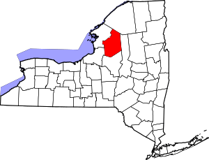 | |
| Villages | ||
| Other hamlets | ||
This article is issued from
Wikipedia.
The text is licensed under Creative Commons - Attribution - Sharealike.
Additional terms may apply for the media files.