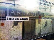
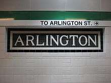
Arlington station (MBTA)
ARLINGTON | ||||||||||||||||||||||||||||||||||||
|---|---|---|---|---|---|---|---|---|---|---|---|---|---|---|---|---|---|---|---|---|---|---|---|---|---|---|---|---|---|---|---|---|---|---|---|---|
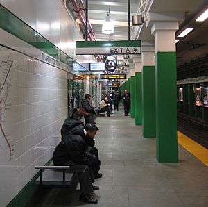 Outbound platform in December 2009 | ||||||||||||||||||||||||||||||||||||
| Location |
20 Arlington Street Boston, Massachusetts | |||||||||||||||||||||||||||||||||||
| Coordinates | 42°21′07″N 71°04′15″W / 42.35186°N 71.070728°WCoordinates: 42°21′07″N 71°04′15″W / 42.35186°N 71.070728°W | |||||||||||||||||||||||||||||||||||
| Owned by | Massachusetts Bay Transportation Authority | |||||||||||||||||||||||||||||||||||
| Line(s) |
Green Line (all branches) | |||||||||||||||||||||||||||||||||||
| Platforms | 2 side platforms | |||||||||||||||||||||||||||||||||||
| Tracks | 2 | |||||||||||||||||||||||||||||||||||
| Construction | ||||||||||||||||||||||||||||||||||||
| Disabled access | Yes | |||||||||||||||||||||||||||||||||||
| History | ||||||||||||||||||||||||||||||||||||
| Opened | November 13, 1921[1] | |||||||||||||||||||||||||||||||||||
| Rebuilt | May 31, 2009 | |||||||||||||||||||||||||||||||||||
| Traffic | ||||||||||||||||||||||||||||||||||||
| Passengers (2013) | 8,519 (weekday average boardings)[2] | |||||||||||||||||||||||||||||||||||
| Services | ||||||||||||||||||||||||||||||||||||
| ||||||||||||||||||||||||||||||||||||
Arlington is a station on the light rail MBTA Green Line. located at the southwest corner of the Boston Public Garden at the corner of Arlington and Boylston Streets. Arlington was not part of the 1914-opened Boylston Street Subway; its construction was delayed by World War I and the station opened in 1921.
Location
Arlington station is located at the eastern end of the Back Bay neighborhood, at the intersection of Arlington Street and Boylston Street, in one of the most prosperous areas of Boston.[3] The station's prime location means that it is close to many popular attractions in the Back Bay area. Arlington is the most convenient station to reach the Boston Public Garden, as it is on the southwestern corner of the park.[3] The station also serves Bay Village, one of Boston's smallest and least-known neighborhoods.
History
After the success of the original Tremont Street Subway in 1897–1898, there was a push to extend the tunnel under Boylston Street towards Kenmore Square.[4] During 1913 tunnel excavations near the present-day site of Arlington station, remains of ancient fish weirs built by Native Americans were found approximately 30 feet (9.1 m) below street level. Their age has been estimated as between 2,000 and 3,600 years.[4][5]
Businesses in the Back Bay neighborhood along Boylston Street between Clarendon and Tremont Streets became worried about loss of income due to being bypassed by an uninterrupted 4,000-foot (1,200 m) tunnel between Boylston and Copley stations, which was completed in 1914. They lobbied for an infill station near Arlington Street, but were rebuffed by the Boston Elevated Railway and the state legislature. In 1915, with the backing of Boston mayor James Michael Curley, they succeeded in getting legislative approval for a new underground station.[4]
After delays caused by World War I, Arlington station finally opened in 1921, and remained in continuous use through its first major renovation, in 1967.[6][1] The Berkeley Street entrance was closed on January 3, 1981 as part of extensive cutbacks that including closing Bowdoin and Symphony.[7]
2006–2009 renovations
In 2006, the MBTA announced that it would again renovate Arlington, Copley, and Kenmore stations, to upgrade for handicapped accessibility and general station maintenance.[8] On November 22, 2006, the main entrance to Arlington station closed for extensive construction and originally was not scheduled to re-open until March 1, 2008. Until completion, all access to Arlington station would be through long–closed alternative entrances at the corner of Boylston and Berkeley Streets.
In 2007, construction crews working on the Arlington Station project were telling people that the summer 2009 target would be difficult to achieve — that the renovations would most likely be completed closer to the summer of 2010. However, on May 31, 2009, the temporary Berkeley Street entrances were reverted to emergency-only exits, and the long-awaited renovated main entrances on Arlington Street reopened for public use.[9]
Station layout
Track Layout | ||||||||||||||||||||||||||||||||||||||||||||||||||||||||||||||||||||||
|---|---|---|---|---|---|---|---|---|---|---|---|---|---|---|---|---|---|---|---|---|---|---|---|---|---|---|---|---|---|---|---|---|---|---|---|---|---|---|---|---|---|---|---|---|---|---|---|---|---|---|---|---|---|---|---|---|---|---|---|---|---|---|---|---|---|---|---|---|---|---|
| ||||||||||||||||||||||||||||||||||||||||||||||||||||||||||||||||||||||
| Ground | Street Level | Exit/Entrance |
| Mezzanine | Concourse | Fare control, free crossover between platforms |
| Green Line platforms |
Side platform, doors will open on the right | |
| Outbound | ← Green Line toward Boston College, Cleveland Circle, Riverside, or Heath (Copley) | |
| Inbound | → Green Line toward Lechmere, North Station, Government Center, or Park Street (Boylston) → | |
| Side platform, doors will open on the right | ||
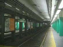
Still structured as it was when originally opened, Arlington has two tracks with two side platforms.[10] In normal service, there are three entrances and exits, all at the intersection of Arlington Street and Boylston Street on the southwestern, southeastern and northwestern corners of that intersection. All entrances serve both the inbound and outbound platforms since they connect to a common mezzanine where there is only one row of faregates.
Unlike several other underground stations on the Green Line, there is a free crossover at the station, allowing passengers to reverse direction without paying an extra fare. In particular, inbound passengers (traveling towards Lechmere) on the Green Line "E" branch must travel past Copley station into Arlington station to reverse direction or to travel outbound on any other Green Line branch.
As of December 2016, the MBTA is considering reopening the Berkeley Street entrance and adding elevators for accessibility.[11]
Artwork
In addition to standard MBTA route maps and maps of the immediate neighborhood, panels of artwork decorate the station at the platform level. Designed by Ross Miller, these panels explain and celebrate the ancient Boylston Street Fishweir that had been discovered during excavations in the vicinity.[12] Casual observers may not notice that several images of modern Native Americans have been concealed among the tangled sticks of the fish weirs pictured on the panels.[13]
References
- 1 2 Belcher, Jonathan (27 June 2015). "Changes to Transit Service in the MBTA district 1964-2015" (PDF). NETransit. Retrieved 13 December 2015.
- ↑ "Ridership and Service Statistics" (PDF) (14th ed.). Massachusetts Bay Transportation Authority. 2014.
- 1 2 Arlington station MBTA Retrieved 2008-11-29
- 1 2 3 Koebel, Romin (2005). "Boston Transit Milestones". MIT Open Courseware. Archived from the original on 2006-09-20. Retrieved 2012-08-01.
- ↑ Decima, Elena B.; Dincauze, Dena F. "The Boston Back Bay Fish Weirs" (PDF). Retrieved 2015-05-08.
- ↑ "Officials Celebrate Modernization of Arlington Station". MBTA.com. Massachusetts Bay Transportation Authority. 2009-06-01. Retrieved 2015-05-08.
- ↑ "BOWDOIN, SYMPHONY T STATIONS CLOSE TODAY". Boston Globe. January 3, 1981 – via Proquest Historical Newspapers. (Subscription required (help)).
- ↑ Transit projects: Arlington station MBTA Retrieved 2008-11-30
- ↑ Back Bay T Station Reopens with Improved Access for Disabled Riders, Boston Globe
- ↑ Green Line subway NYCSubway Retrieved 2008-11-29
- ↑ Brelsford, Laura (December 5, 2016). "MBTA System-Wide Accessibility Initiatives: December 2016 Update" (PDF). Massachusetts Bay Transportation Authority Department of System-Wide Accessibility. p. 10.
- ↑ "Ancient Fishweir Murals". Museum Without Walls. cultureNOW. Retrieved 2015-05-08.
- ↑ Annear, Steve (January 4, 2013). "Hidden Images at MBTA Green Line Station Reveal Deep History of Boston's Back Bay". BostInno. Streetwise Media. Retrieved 2015-05-08.
External links
| Wikimedia Commons has media related to Arlington (MBTA station). |