Northeastern University station
NORTHEASTERN | |||||||||||
|---|---|---|---|---|---|---|---|---|---|---|---|
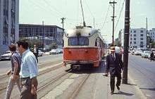
 Northeastern University station as seen from Forsyth Street. | |||||||||||
| Location |
Huntington Avenue at Opera Place Boston, Massachusetts | ||||||||||
| Coordinates | 42°20′23″N 71°05′25″W / 42.3397°N 71.0903°WCoordinates: 42°20′23″N 71°05′25″W / 42.3397°N 71.0903°W | ||||||||||
| Owned by | Massachusetts Bay Transportation Authority | ||||||||||
| Line(s) |
Green Line "E" branch | ||||||||||
| Platforms | 2 side platforms | ||||||||||
| Tracks | 2 | ||||||||||
| Connections |
| ||||||||||
| Construction | |||||||||||
| Disabled access | Yes | ||||||||||
| History | |||||||||||
| Opened | February 16, 1941 | ||||||||||
| Rebuilt | 2002–May 26, 2003[1] | ||||||||||
| Previous names | Opera Place (1941-1947) | ||||||||||
| Traffic | |||||||||||
| Passengers (2011) | 2,650[2] | ||||||||||
| Services | |||||||||||
| |||||||||||
Northeastern University (signed as Northeastern) is a surface-level trolley stop on the MBTA Green Line. It is located in a dedicated median along Huntington Avenue in Boston, between Opera Place and Forsyth Street, and is adjacent to the Krentzman Quad on the campus of Northeastern University. It is the first surface-level stop going outbound along the Green Line "E" Branch; trolleys rise from a portal located between Opera Place and Gainsborough Street and continue along the surface down Huntington Avenue towards Mission Hill.
History
The modern Green Line "E" Branch opened on February 16, 1941 with the completion of the Huntington Avenue subway from Copley to the Northeastern Incline. (Before then, trams had run on the surface from the Boylston Street portal). On May 21, 1947, the Boston Elevated Railway board voted to change the name from Opera Place to Northeastern University.[3] The stop was named on maps as early as the 1951 M.T.A. route map, while most other surface stops (save for Brigham Circle and Heath Street) did not appear separately until around 1990.[4]
Until bare asphalt platforms were installed in the 1970s, there were no real stations on much of the surface portion of the line; passengers merely waited on street corners and boarded from the street.[3] However, Northeastern University received platforms much earlier due to its high traffic. In a renovation that took place in 2002 and 2003, a new handicapped-accessible station was built between Opera Place and Forsyth Street. Temporary platforms were built northeast of Opera Place during the renovations; a station sign is still in place. The rebuilt station opened on May 26, 2003.[1]
On August 23, 2004, a Type 8 Breda low-floor trolley derailed at the station, causing scarring in the outbound platform near the pedestrian crossing on the Opera Place side of the station.[5]
Bus connections
- 39 Forest Hills Station – Back Bay Station via Huntington Avenue
References
- 1 2 "Transportation Short Notes" (PDF). TRANSreport. Boston Metropolitan Planning Organization. July 2003. p. 3. Archived from the original (PDF) on January 16, 2011.
- ↑ "Ridership and Service Statistics" (PDF) (14th ed.). Massachusetts Bay Transportation Authority. 2014.
- 1 2 Clarke, Bradley H. (2003). Streetcar Lines of the Hub - The 1940s. Boston Street Railway Association. p. 93, 98. ISBN 0938315056.
- ↑ Metropolitan Transit Authority (1951). "Metropolitan Transit Authority System Route Map 2nd Edition". Retrieved 14 December 2013.
- ↑ "Derailment disrupts Green Line E service". Boston Globe. August 23, 2014.
External links
| Wikimedia Commons has media related to Northeastern University station. |
- MBTA - Northeastern University
- Google Maps Street View: Opera Place entrance, Forsyth Street entrance