Gold Canyon, Arizona
| Gold Canyon, Arizona | |
|---|---|
| CDP | |
 Location of Gold Canyon in Pinal County, Arizona | |
 Gold Canyon, Arizona Location in the United States | |
| Coordinates: 33°21′43″N 111°27′6″W / 33.36194°N 111.45167°WCoordinates: 33°21′43″N 111°27′6″W / 33.36194°N 111.45167°W | |
| Country | United States |
| State | Arizona |
| County | Pinal |
| Area[1] | |
| • Total | 22.39 sq mi (57.99 km2) |
| • Land | 22.39 sq mi (57.99 km2) |
| • Water | 0.00 sq mi (0.00 km2) |
| Elevation | 1,982 ft (604 m) |
| Population (2010) | |
| • Total | 7,532 |
| • Estimate (2016)[2] | N/A |
| Time zone | UTC-7 (MST (no DST)) |
| Area code(s) | 480 |
| FIPS code | 04-28120 |
| GNIS feature ID | 1853159 |
| Website | http://www.goldcanyon.net/ |
Gold Canyon is a census-designated place (CDP) in Pinal County, Arizona, United States. The population was 10,159 at the 2010 census. The community is sometimes incorrectly called Gold Camp.
The town name is not recognized on weather statements issued by the National Weather Service. The closest city to Gold Canyon is Apache Junction, Arizona.
It was one of the filming locations for HBO's 1994 film Blind Justice.
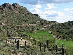
The scenery photos from the beginning of Three Amigos are from Gold Canyon, not Mexico as depicted in the film. The mountain shown is part of the Superstition Mountains, shown from a view point in Gold Canyon.
Local Media
On August 7, 2014, Gold Canyon Public Radio (KRWV-FM 99.3) "The Wave" 176 Watts/100 Watts ERP (http://www.goldcanyonpublicradio.org) was established and became the first FCC licensed radio station for Gold Canyon, Arizona serving the communities of Gold Canyon, San Tan Valley, Queen Creek, Queen Valley, Apache Junction and to the east near Superior, AZ. KRWV-FM (Gold Canyon Public Radio) is a non-profit broadcast facility. Gold Canyon Public Radio's format includes Smooth Jazz, Local News, Local Event Announcements, Health and Wellness Programming, Specialized Programming and Emergency Weather Announcements. KRWV-FM is financially supported by local businesses and listeners. Studio: 480-288-5800 Business: 602-625-3000.
Geography
Gold Canyon is located at 33°21′43″N 111°27′6″W / 33.36194°N 111.45167°W (33.361913, -111.451629).[3]
According to the United States Census Bureau, the CDP has a total area of 22.3 square miles (57.8 km²), all of it land.
Demographics
| Historical population | |||
|---|---|---|---|
| Census | Pop. | %± | |
| U.S. Decennial Census[4] | |||
As of the census[5] of 2000, there were 6,029 people, 2,785 households, and 2,211 families residing in the CDP. (In 2007, the population was recounted and was declared 10,064.) The population density was 270.0 people per square mile (104.2/km²). There were 4,139 housing units at an average density of 185.4/sq mi (71.6/km²). The racial makeup of the CDP was 96.20% White, 0.30% Black or African American, 0.66% Native American, 0.48% Asian, 0.07% Pacific Islander, 1.36% from other races, and 0.93% from two or more races. 3.53% of the population were Hispanic or Latino of any race.
There were 2,785 households out of which 13.0% had children under the age of 18 living with them, 73.8% were married couples living together, 3.5% had a female householder with no husband present, and 20.6% were non-families. 16.1% of all households were made up of individuals and 6.4% had someone living alone who was 65 years of age or older. The average household size was 2.16 and the average family size was 2.38.
In the CDP, the population was spread out with 12.4% under the age of 18, 3.0% from 18 to 24, 17.8% from 25 to 44, 37.0% from 45 to 64, and 29.8% who were 65 years of age or older. The median age was 56 years. For every 100 females, there were 95.9 males. For every 100 females age 18 and over, there were 95.5 males.
The median income for a household in the CDP was $57,705, and the median income for a family was $60,438. Males had a median income of $47,727 versus $31,583 for females. The per capita income for the CDP was $35,010. About 2.8% of families and 3.8% of the population were below the poverty line, including 10.6% of those under age 18 and 2.4% of those age 65 or over.[6]
Attractions
- Gold Canyon is the closest community to the Arizona Renaissance Festival.
- The Safeway International LPGA golf tournament is held at Superstition Mountain Golf and Country Club in Gold Canyon.
References
- ↑ "2016 U.S. Gazetteer Files". United States Census Bureau. Retrieved July 18, 2017.
- ↑ "Population and Housing Unit Estimates". Retrieved June 9, 2017.
- ↑ "US Gazetteer files: 2010, 2000, and 1990". United States Census Bureau. February 12, 2011. Retrieved April 23, 2011.
- ↑ "Census of Population and Housing". Census.gov. Retrieved June 4, 2016.
- ↑ "American FactFinder". United States Census Bureau. Archived from the original on September 11, 2013. Retrieved January 31, 2008.
- ↑ Census Bureau fact sheet for Gold Camp
