Gjoa Haven Airport
| Gjoa Haven Airport | |||||||||||
|---|---|---|---|---|---|---|---|---|---|---|---|
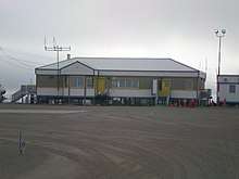 Gjoa Haven terminal from airside | |||||||||||
| Summary | |||||||||||
| Airport type | Public | ||||||||||
| Operator | Government of Nunavut | ||||||||||
| Location | Gjoa Haven, Nunavut | ||||||||||
| Time zone | MST (UTC−07:00) | ||||||||||
| • Summer (DST) | MDT (UTC−06:00) | ||||||||||
| Elevation AMSL | 154 ft / 47 m | ||||||||||
| Coordinates | 68°38′08″N 095°51′01″W / 68.63556°N 95.85028°WCoordinates: 68°38′08″N 095°51′01″W / 68.63556°N 95.85028°W | ||||||||||
| Map | |||||||||||
 CYHK Location in Nunavut | |||||||||||
| Runways | |||||||||||
| |||||||||||
| Statistics (2010) | |||||||||||
| |||||||||||
Gjoa Haven Airport (IATA: YHK, ICAO: CYHK) is located 1.5 nautical miles (2.8 km; 1.7 mi) southwest of Gjoa Haven, Nunavut, Canada, and is operated by the government of Nunavut.
The airport is a single storey building and located next to several trailers. The runway and taxiways are gravel or dirt. The runway is not marked and other than a NDB lacks navigation aids.[1]
Airlines and destinations
| Airlines | Destinations |
|---|---|
| Canadian North | Cambridge Bay, Kugaaruk, Kugluktuk, Taloyoak, Yellowknife[4] |
| First Air | Cambridge Bay, Kugaaruk, Taloyoak, Yellowknife[5] |
References
- 1 2 Canada Flight Supplement. Effective 0901Z 19 July 2018 to 0901Z 13 September 2018.
- ↑ Synoptic/Metstat Station Information Archived December 1, 2011, at the Wayback Machine.
- ↑ Total aircraft movements by class of operation
- ↑ Flight Schedule and Route Map Archived July 8, 2011, at the Wayback Machine..
- ↑ First Air interactive weather/route map Archived 2008-09-17 at the Wayback Machine.
External links
- Past three hours METARs, SPECI and current TAFs for Gjoa Haven Airport from Nav Canada as available.
| By name | |
|---|---|
| By location indicator | |
| By province/territory | |
| By area | |
| National Airports System | |
| Related | |
| |
This article is issued from
Wikipedia.
The text is licensed under Creative Commons - Attribution - Sharealike.
Additional terms may apply for the media files.