Ghoubbet-el-Kharab
| Ghoubbet-el-Kharab قبة الخراب | |
|---|---|
 | |
| Basin countries |
|
| Max. length | 13 mi (21 km) |
| Max. width | 7 mi (11 km) |
| Surface area | 158 km2 (61 sq mi) |
| Average depth | −205 m (−673 ft) |
| Salinity | 3.7–3.8% |
| Max. temperature | 32 °C (90 °F) |
| Min. temperature | 27 °C (81 °F) |
| Islands | Devil's Islands, Abou Maya Island |
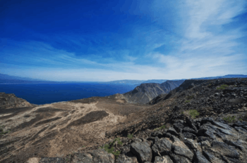
The Ghoubbet al-Kharab (قبة الخراب, "the Gulf of the Demons") is a Djiboutian cove separated from the Gulf of Tadjoura by a violent current. Ghoubbet al-Kharab is surrounded by mountains and cliffs 600 meters high, as well as by the Ardoukôba volcano which separates it from Lake Assal. It is very deep (200 meters) and hosts many fish and sharks that grow strong gulf currents. This luxuriance attracts fishermen who make the road from Djibouti City. The cove is visited by divers and scientists like Commander Cousteau.
Ghoubbet-el-Kharab
The Ghoubbet al-Kharab can be up to one meter from the sea level, because of the narrowness of the pass, but also the tides and winds. In the middle of the Ghoubbet al-Kharab are two volcanic islands: the Devil's Islands.
External links
| Authority control |
|---|
This article is issued from
Wikipedia.
The text is licensed under Creative Commons - Attribution - Sharealike.
Additional terms may apply for the media files.