U.S. Route 84 in Georgia
| |||||||
|---|---|---|---|---|---|---|---|
 | |||||||
| Route information | |||||||
| Maintained by GDOT | |||||||
| Length | 258.0 mi[1] (415.2 km) | ||||||
| Major junctions | |||||||
| West end |
| ||||||
| East end |
| ||||||
| Location | |||||||
| Counties | Early, Seminole, Decatur, Grady, Thomas, Brooks, Lowndes, Lanier, Clinch, Ware, Pierce, Wayne, Long, Liberty | ||||||
| Highway system | |||||||
| |||||||

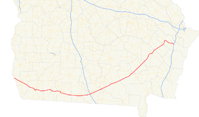
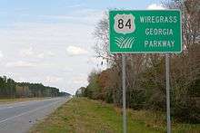
U.S. Route 84 (US 84) is a 258-mile-long (415 km) U.S. Highway in the U.S. state of Georgia, is also signed as State Route 38 for its entire length in Georgia. After entering Georgia from Alabama west-northwest of Jakin, the highway travels through the southern portion of the state, meeting its eastern terminus at Interstate 95 (I-95) east of Midway. US 84 through Georgia is also known as the Wiregrass Georgia Parkway.
Route description
After entering the state from Alabama, US 84/SR 38 travels east through Donalsonville to Bainbridge. The highways travel around the city to the south on a freeway bypass, cosigned with US 27/SR 1. The highway continues east through Cairo to Thomasville, where it bypasses downtown to the north and east, concurrent with US 319 and SR 35, then US 19/SR 3/SR 300. The highway then continues east to Quitman, where it becomes concurrent with US 221/SR 76/SR 333 to the east, past its interchange with Interstate 75 (I-75), to Valdosta. In Valdosta, US 221 departs, and US 84/SR 38 continues east-northeast to Waycross, where it is briefly concurrent with US 1, US 23, US 82, SR 4, and SR 520. US 84/SR 38 continues northeast from Waycross, traveling through Blackshear before arriving in Jesup. In Jesup, the highway becomes concurrent with US 25, US 301, and SR 23 northeast to Ludowici. In Ludowici, US 25, US 301, and SR 23 depart to the northwest, and US 84/SR 38 continues northeast to Hinesville. In Hinesville, the highway becomes concurrent with SR 196, and takes a drastic turn to the east. A short distance later, SR 196 departs, and US 84/SR 38 continues east to their eastern terminus at exit 76 on I-95 east of Midway. Here, the roadway continues as Islands Highway.
US 84 is a very significant route in southern Georgia. Almost all of the route sees an Average Annual Daily Traffic (AADT) of 5,000 vehicles or more, and the AADT exceeds 20,000 vehicles in and around Waycross and Hinesville.[2] Because of this, most of the route is a multi-lane divided highway, especially west of Valdosta.
History
Formerly, US 84 met its eastern terminus at US 17/SR 25 west of Brunswick, while US 82 followed the present alignment of US 84 to Midway. However, with the realignment of highways near Waycross, the terminus of the two highways were swapped. In addition, a segment of the highway between Boston and Quitman was relocated to a more northerly routing in 1966, with the former routing being renumbered as State Route 364. SR 364 was decommissioned in 1982.[3]
Major intersections
| County | Location | mi | km | Destinations | Notes |
|---|---|---|---|---|---|
| Early | | Western terminus of US 84/SR 38 | |||
| Saffold | |||||
| Jakin | Pearl Street | Former SR 39 Spur north | |||
| Seminole | Donalsonville | ||||
| Iron City | Southern terminus of SR 45 | ||||
| Decatur | | Eastern terminus of SR 285 | |||
| Brinson | |||||
| Bainbridge | Northern terminus of SR 253 Spur | ||||
| Interchange; western end of US 27/SR 1 concurrency; northern terminus of US 27 Bus./SR 1 Bus. | |||||
| Interchange | |||||
| Interchange; northern terminus of SR 97 Conn.; western terminus of US 84 Bus./SR 38 Bus. | |||||
| Interchange | |||||
| Interchange; eastern end of US 27/SR 1 concurrency; southern terminus of US 27 Bus./SR 1 Bus. | |||||
| Eastern terminus of US 84 Bus./SR 38 Bus. | |||||
| Climax | |||||
| Grady | Whigham | McGriff Street | Former SR 179 | ||
| Cairo | Southern terminus of SR 112 | ||||
| Eastern terminus of SR 38 Spur | |||||
| Thomas | | Cairo Road – Downtown Thomasville | |||
| | Western end of US 319/SR 35 concurrency | ||||
| | Western end of SR 3 Alt. concurrency; western terminus of US 84 Bus./SR 38 Bus. | ||||
| | Eastern end of US 319/SR 35 and SR 3 Alt. concurrencies; western end of US 19/SR 3/SR 300 concurrency | ||||
| Thomasville | Southern terminus of SR 35 Conn. | ||||
| Western terminus of SR 122 | |||||
| Interchange; eastern end of US 19/SR 3/SR 300 concurrency | |||||
| Boston | Southern terminus of SR 33 | ||||
| Brooks | Quitman | Western end of US 221 and SR 76/SR 333 concurrencies | |||
| Eastern end of SR 76/SR 333 concurrency | |||||
| Lowndes | Valdosta | I-75 exit 16; southern terminus of I-75 Bus.; southern end of I-75 Bus. concurrency | |||
| Southern terminus of SR 133 | |||||
| Eastern end of I-75 Bus. concurrency | |||||
| Eastern end of US 221 concurrency | |||||
| Naylor | |||||
| Lanier | Stockton | ||||
| Clinch | | Eastern terminus of SR 37 | |||
| Homerville | |||||
| Ware | Waycross | Western end of US 1/US 23/US 82/SR 4/SR 520 concurrency | |||
| Eastern end of US 1/US 23/US 82/SR 4/SR 520 concurrency | |||||
| Western end of US 1 Bus./US 23 Bus./SR 4 Bus. concurrency | |||||
| Eastern end of US 1 Bus./US 23 Bus./SR 4 Bus. concurrency | |||||
| Pierce | Blackshear | ||||
| Patterson | |||||
| Wayne | | Northern terminus of SR 203 | |||
| Jesup | |||||
| Interchange; western end of US 25/US 301/SR 23 concurrency | |||||
| Long | Ludowici | Eastern end of US 25/US 301/SR 23 concurrency | |||
| Liberty | Walthourville | ||||
| Hinesville | Western end of SR 196 concurrency | ||||
| General Screven Road – Fort Stewart, Pembroke | Former SR 196 west | ||||
| Eastern terminus of SR 38 Conn. | |||||
| McIntosh | Eastern end of SR 196 concurrency | ||||
| Midway | |||||
| I-95 exit 76; eastern terminus of US 84 and SR 38 | |||||
1.000 mi = 1.609 km; 1.000 km = 0.621 mi
| |||||
Special routes
SR 38 Spur (Cairo)
| |
|---|---|
| Location | Cairo, Georgia |
| Length | 0.90 mi[4] (1.4 km) |
State Route 38 Spur (SR 38 Spur) is a short west–east spur route in Cairo connecting SR 93/SR 111 in downtown with the US 84/SR 38 mainline in the eastern part of the city.
The entire route is in Cairo, Grady County.
| mi[4] | km | Destinations | Notes | ||
|---|---|---|---|---|---|
| 0.0 | 0.0 | Western terminus | |||
| 0.4 | 0.64 | ||||
| 0.9 | 1.4 | Eastern terminus | |||
| 1.000 mi = 1.609 km; 1.000 km = 0.621 mi | |||||
SR 38 Connector (Hinesville)
| |
|---|---|
| Location | Hinesville |
| Length | 1.7 mi[5] (2.7 km) |
State Route 38 Connector (SR 38 Conn.) is a short west–east connecting route of SR 38. It connects SR 119 on the Hinesville–Fort Stewart line with US 84/SR 38/SR 196 in northeast Hinesville just west of the Hinesville–Flemington line. It is known as General Stewart Way for its entire length.
The entire route is in Liberty County.
| Location | mi | km | Destinations | Notes | |
|---|---|---|---|---|---|
| Fort Stewart–Hinesville line | 0.0 | 0.0 | Western terminus of SR 38 Conn.; eastern terminus of Saunders Avenue | ||
| Hinesville | 1.7 | 2.7 | Eastern terminus | ||
| 1.000 mi = 1.609 km; 1.000 km = 0.621 mi | |||||
See also

.svg.png)
References
- ↑ Google (December 31, 2016). "Overview map of US 84" (Map). Google Maps. Google. Retrieved December 31, 2016.
- ↑ "Archived copy" (PDF). Archived from the original (PDF) on 2007-09-25. Retrieved 2010-10-23.
- ↑ http://www.geocities.com/garoadwarrior76/garoutelog361_380.html Accessed January 24, 2007
- 1 2 Google (March 3, 2017). "Overview map of SR 38 Spur" (Map). Google Maps. Google. Retrieved March 3, 2017.
- ↑ Google (March 4, 2017). "Overview map of SR 38 Conn." (Map). Google Maps. Google. Retrieved March 4, 2017.
External links
Route map:
| Previous state: Alabama |
Georgia | Next state: Terminus |